
Mount Ōdaigahara
日出ケ岳
Ōdai-chō, Mie / Kamikitayama, Nara · Elevation 1,695 m
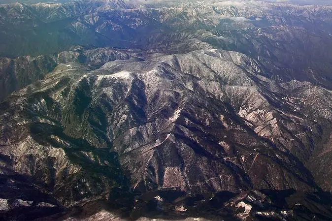
Mount Ōdaigahara (Hide-ga-take, 1,695 m) is the highest peak of the Taikō Mountains, straddling Kamikitayama Village in Nara and Ōdai Town / Kawakami Village in Mie, and the highest point in Nara Prefecture. Designated a Special Protection Zone within Yoshino-Kumano National Park, it ranks alongside Yakushima as one of Japan's wettest regions. The summit area offers views of the Kumano-nada, the Daijagura cliff lookout, and the Masakigahara plateau amid primeval forest carpeted in moss. The Ōdaigahara Driveway reaches an elevation of 1,570 m, putting a beginner-friendly loop hike on this 100 Famous Japanese Mountain within reach.
Mount Ōdaigahara at a glance
- Weather: The most settled day in the next 7 days is Mon, November 9: clear, gusts up to 6 m/s.
- Route: The shortest is East Odaigahara: Hinodegatake and Daijagura Circuit: about 4 h 13 min, 7.5 km, about 420 m of climbing.
Mount Ōdaigahara weather (hourly, 14 days)
Sunrise today 06:16, sunset 17:02
| Tue, 11/3 | Wed, 11/4 | Thu, 11/5 | Fri, 11/6 | Sat, 11/7 | Sun, 11/8 | Mon, 11/9 | Tue, 11/10 | Wed, 11/11 | Thu, 11/12 | Fri, 11/13 | Sat, 11/14 | Sun, 11/15 | Mon, 11/16 | Tue, 11/17 | |||||||||||||||||||||||||||||||||||||||||||||||||||||||||||||||||||||||
|---|---|---|---|---|---|---|---|---|---|---|---|---|---|---|---|---|---|---|---|---|---|---|---|---|---|---|---|---|---|---|---|---|---|---|---|---|---|---|---|---|---|---|---|---|---|---|---|---|---|---|---|---|---|---|---|---|---|---|---|---|---|---|---|---|---|---|---|---|---|---|---|---|---|---|---|---|---|---|---|---|---|---|---|---|---|
| Japan time | 15 | 17 | 19 | 21 | 23 | 1 | 3 | 5 | 7 | 9 | 11 | 13 | 15 | 18 | 21 | 0 | 3 | 6 | 9 | 12 | 15 | 18 | 21 | 0 | 3 | 6 | 9 | 12 | 15 | 18 | 21 | 0 | 3 | 6 | 9 | 12 | 15 | 18 | 21 | 0 | 3 | 6 | 9 | 12 | 15 | 18 | 21 | 0 | 3 | 6 | 9 | 15 | 21 | 3 | 9 | 15 | 21 | 3 | 9 | 15 | 21 | 3 | 9 | 15 | 21 | 3 | 9 | 15 | 21 | 3 | 9 | 15 | 21 | 3 | 9 | 15 | 21 | 3 | 9 | 15 | 21 | 3 | 9 | 15 | |
 |   |   | | | |   | |   | |   |   | |   | | | | | | |   | | | |   | | | | |  | | | | | | | | | | | | | | | |   | | | | | | | | | |   |   | | | | |  | | | | | | | | | | | | | | | |   | | | |  | | | ||
| Temperature | °C | 12° | 7° | 5° | 5° | 3° | 2° | 4° | 4° | 4° | 9° | 10° | 8° | 7° | 6° | 6° | 7° | 8° | 7° | 10° | 12° | 11° | 9° | 7° | 5° | 6° | 8° | 10° | 13° | 11° | 7° | 4° | 3° | 2° | 0° | 4° | 5° | 5° | 1° | -2° | -2° | -3° | -2° | 5° | 9° | 8° | 2° | 1° | 2° | 0° | 1° | 8° | 9° | 1° | -1° | 7° | 8° | 0° | 0° | 2° | 4° | -1° | -3° | 5° | 7° | -2° | -4° | 4° | 5° | -2° | -3° | 5° | 7° | 1° | 1° | 7° | 7° | 6° | 7° | 10° | 10° | 3° | -1° | 4° | 7° |
| Precipitation | mm | 0.1 | 0.3 | 2.0 | 2.1 | 2.1 | 0.8 | 0.1 | 0.6 | 0.7 | 0.2 | 0.7 | 0.4 | 0.1 | 1.6 | 7 | 15 | 0.5 | 0.3 | ||||||||||||||||||||||||||||||||||||||||||||||||||||||||||||||||||
| New snow | cm | ||||||||||||||||||||||||||||||||||||||||||||||||||||||||||||||||||||||||||||||||||||
| Snow depth | cm | 0 | 0 | 0 | 0 | 0 | 0 | 0 | 0 | 0 | 0 | 0 | 0 | 0 | 0 | 0 | 0 | 0 | 0 | 0 | 0 | 0 | 0 | 0 | 0 | 0 | 0 | 0 | 0 | 0 | 0 | 0 | 0 | 0 | 0 | 0 | 0 | 0 | 0 | 0 | 0 | 0 | 0 | 0 | 0 | 0 | 0 | 0 | 0 | 0 | 0 | 0 | 0 | 0 | 0 | 0 | 0 | 0 | 0 | 0 | 0 | 0 | 0 | 0 | 0 | 0 | 0 | 0 | 0 | 0 | 0 | 0 | 0 | 0 | 0 | 0 | 0 | 0 | 0 | 0 | 0 | 0 | 0 | 0 | 0 |
| Wind | m/s | 1 | 1 | 2 | 2 | 3 | 3 | 3 | 3 | 3 | 1 | 2 | 1 | 1 | 1 | 1 | 0 | 0 | 2 | 1 | 1 | 1 | 0 | 1 | 1 | 1 | 1 | 2 | 1 | 2 | 0 | 1 | 1 | 1 | 2 | 2 | 3 | 3 | 1 | 1 | 1 | 1 | 1 | 2 | 0 | 1 | 2 | 2 | 1 | 1 | 2 | 0 | 1 | 2 | 1 | 1 | 0 | 2 | 4 | 3 | 5 | 2 | 2 | 1 | 1 | 1 | 2 | 1 | 4 | 3 | 3 | 1 | 2 | 1 | 1 | 1 | 1 | 2 | 1 | 2 | 2 | 3 | 2 | 2 | 2 |
| Wind gusts | m/s | 6 | 5 | 6 | 6 | 7 | 7 | 8 | 8 | 8 | 7 | 7 | 7 | 5 | 6 | 6 | 6 | 5 | 4 | 5 | 5 | 5 | 4 | 5 | 6 | 8 | 8 | 8 | 7 | 8 | 9 | 7 | 8 | 9 | 10 | 10 | 11 | 12 | 10 | 7 | 7 | 7 | 7 | 7 | 8 | 6 | 5 | 6 | 5 | 4 | 6 | 6 | 6 | 6 | 6 | 5 | 8 | 7 | 16 | 19 | 17 | 14 | 8 | 7 | 6 | 6 | 6 | 8 | 13 | 12 | 9 | 6 | 7 | 6 | 4 | 6 | 7 | 9 | 11 | 8 | 10 | 12 | 12 | 9 | 8 |
| Wind dir. | ↓ | ↓ | ↓ | ↓ | ↓ | ↓ | ↓ | ↓ | ↓ | ↓ | ↓ | ↓ | ↓ | ↓ | ↓ | ↓ | ↓ | ↓ | ↓ | ↓ | ↓ | ↓ | ↓ | ↓ | ↓ | ↓ | ↓ | ↓ | ↓ | ↓ | ↓ | ↓ | ↓ | ↓ | ↓ | ↓ | ↓ | ↓ | ↓ | ↓ | ↓ | ↓ | ↓ | ↓ | ↓ | ↓ | ↓ | ↓ | ↓ | ↓ | ↓ | ↓ | ↓ | ↓ | ↓ | ↓ | ↓ | ↓ | ↓ | ↓ | ↓ | ↓ | ↓ | ↓ | ↓ | ↓ | ↓ | ↓ | ↓ | ↓ | ↓ | ↓ | ↓ | ↓ | ↓ | ↓ | ↓ | ↓ | ↓ | ↓ | ↓ | ↓ | ↓ | ↓ | |
Mount Ōdaigahara hiking routes
- East Odaigahara: Hinodegatake and Daijagura Circuit 7.5 km · Ascent 417 m Odaigahara Visitor Center, 大台ヶ原 (Bus stop) (parking)
- East Ōdaigahara Loop via Hinodegatake and Daijagura 8.1 km · Ascent 323 m Odaigahara Visitor Center, 大台ヶ原 (Bus stop) (parking)
Hiking times are estimates calculated from the terrain.
Huts, campsites and lodging near Mount Ōdaigahara
Mountain huts
Lodging
- 心・湯治館
Lists that include Mount Ōdaigahara
100 Famous Japanese Mountains · Japan 200 Famous Mountains · Japan's 300 Famous Mountains · 100 Famous Mountains of Flowers · 100 Famous Mountains with First-order Triangulation Points · New Japan 100 Famous Mountains · Highest Peaks by Prefecture · Illustrated Collection of Japan's Famous Mountains · Kansai 100 Famous Mountains · Tokai 100 Mountains · Kinki 100 Famous Mountains · Nara 100 Mountains to Explore · Elevations of 1003 Mountains of Japan · 1000 Mountains of Japan
Mount Ōdaigahara facts
- Also known as
- 日出ヶ岳
- Elevation
- 1,695 m
- Location
- Ōdai-chō, Mie / Kamikitayama, Nara
34.185203, 136.109190 - National Park
- 吉野熊野国立公園
- Website
- kinki.env.go.jp
- Trail Map
- kinki.env.go.jp
- Access Information
- www.vill.kamikitayama.nara.jp
- Wikipedia
- ja.wikipedia.org