
Mount Nokogiri
鋸山
Kyonan, Chiba · Elevation 329 m
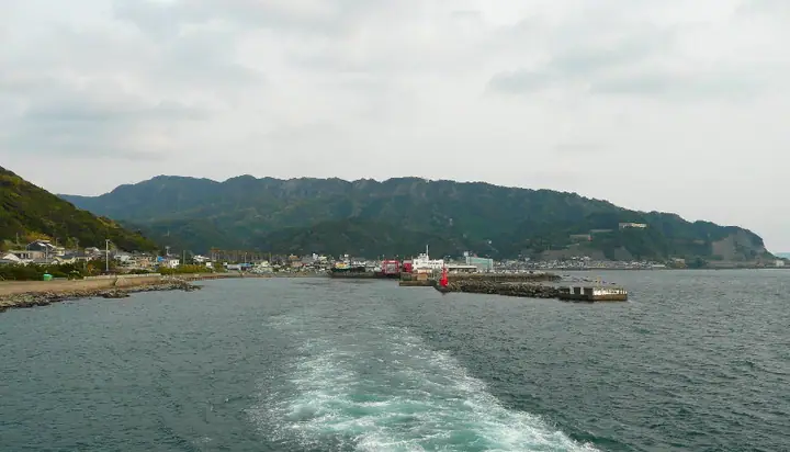
Mount Nokogiri rises 329 m on the western coast of the Boso Peninsula. Its sawtooth rock faces gave the mountain its name, and former Boshu stone quarries remain. Nihonji Temple has a large Buddha, the Hyakushaku Kannon and Jigoku Nozoki, a rocky ledge projecting over a sheer drop with views of Tokyo Bay. A ropeway also provides access to the upper mountain.
Mount Nokogiri at a glance
- Weather: The most settled day in the next 7 days is Fri, November 6: clear, gusts up to 6 m/s. Thu, Nov 5: strong wind (gusts up to 15 m/s).
- Route: The shortest is Mount Nokogiri and Jigoku-nozoki Loop from the Ropeway Summit Station: about 2 h 48 min, 4.0 km, about 510 m of climbing.
Mount Nokogiri weather (hourly, 14 days)
Sunrise today 06:03, sunset 16:46
| Tue, 11/3 | Wed, 11/4 | Thu, 11/5 | Fri, 11/6 | Sat, 11/7 | Sun, 11/8 | Mon, 11/9 | Tue, 11/10 | Wed, 11/11 | Thu, 11/12 | Fri, 11/13 | Sat, 11/14 | Sun, 11/15 | Mon, 11/16 | Tue, 11/17 | |||||||||||||||||||||||||||||||||||||||||||||||||||||||||||||||||||||||
|---|---|---|---|---|---|---|---|---|---|---|---|---|---|---|---|---|---|---|---|---|---|---|---|---|---|---|---|---|---|---|---|---|---|---|---|---|---|---|---|---|---|---|---|---|---|---|---|---|---|---|---|---|---|---|---|---|---|---|---|---|---|---|---|---|---|---|---|---|---|---|---|---|---|---|---|---|---|---|---|---|---|---|---|---|---|
| Japan time | 15 | 17 | 19 | 21 | 23 | 1 | 3 | 5 | 7 | 9 | 11 | 13 | 15 | 18 | 21 | 0 | 3 | 6 | 9 | 12 | 15 | 18 | 21 | 0 | 3 | 6 | 9 | 12 | 15 | 18 | 21 | 0 | 3 | 6 | 9 | 12 | 15 | 18 | 21 | 0 | 3 | 6 | 9 | 12 | 15 | 18 | 21 | 0 | 3 | 6 | 9 | 15 | 21 | 3 | 9 | 15 | 21 | 3 | 9 | 15 | 21 | 3 | 9 | 15 | 21 | 3 | 9 | 15 | 21 | 3 | 9 | 15 | 21 | 3 | 9 | 15 | 21 | 3 | 9 | 15 | 21 | 3 | 9 | 15 | |
  |   |   | | | |   | | |   | | | | | | | | | | |   |   |   | | | |  | | |  |   | | | | | |   | | | | | | | | | | | | | | | | | | | | | | | |   |  | | | | | | | | | | | | | | | | |   | | | | |   | ||
| Temperature | °C | 16° | 15° | 14° | 14° | 15° | 14° | 13° | 12° | 12° | 13° | 14° | 14° | 14° | 12° | 12° | 12° | 12° | 13° | 13° | 16° | 15° | 15° | 14° | 14° | 14° | 13° | 16° | 19° | 18° | 17° | 16° | 15° | 14° | 14° | 15° | 16° | 15° | 14° | 13° | 11° | 11° | 10° | 11° | 12° | 13° | 12° | 12° | 11° | 11° | 10° | 10° | 12° | 10° | 10° | 10° | 11° | 8° | 9° | 12° | 14° | 11° | 7° | 11° | 13° | 11° | 9° | 12° | 14° | 8° | 6° | 9° | 13° | 11° | 10° | 12° | 15° | 16° | 17° | 19° | 19° | 14° | 10° | 10° | 11° |
| Precipitation | mm | 0.2 | 0.2 | 0.6 | 0.1 | 0.1 | 2.0 | 3.6 | 6 | 6 | 5 | 3.5 | 0.1 | 3.7 | 9 | 4.9 | 1.0 | 0.3 | 0.4 | 0.3 | 1.7 | 2.1 | 0.5 | 0.5 | 0.1 | 2.3 | 3.7 | 27 | 10 | ||||||||||||||||||||||||||||||||||||||||||||||||||||||||
| New snow | cm | ||||||||||||||||||||||||||||||||||||||||||||||||||||||||||||||||||||||||||||||||||||
| Snow depth | cm | 0 | 0 | 0 | 0 | 0 | 0 | 0 | 0 | 0 | 0 | 0 | 0 | 0 | 0 | 0 | 0 | 0 | 0 | 0 | 0 | 0 | 0 | 0 | 0 | 0 | 0 | 0 | 0 | 0 | 0 | 0 | 0 | 0 | 0 | 0 | 0 | 0 | 0 | 0 | 0 | 0 | 0 | 0 | 0 | 0 | 0 | 0 | 0 | 0 | 0 | 0 | 0 | 0 | 0 | 0 | 0 | 0 | 0 | 0 | 0 | 0 | 0 | 0 | 0 | 0 | 0 | 0 | 0 | 0 | 0 | 0 | 0 | 0 | 0 | 0 | 0 | 0 | 0 | 0 | 0 | 0 | 0 | 0 | 0 |
| Wind | m/s | 3 | 2 | 2 | 3 | 4 | 5 | 5 | 6 | 6 | 6 | 6 | 6 | 7 | 7 | 6 | 7 | 8 | 8 | 8 | 7 | 3 | 2 | 2 | 3 | 2 | 1 | 1 | 1 | 2 | 2 | 2 | 3 | 3 | 5 | 5 | 4 | 3 | 4 | 5 | 5 | 6 | 6 | 5 | 3 | 3 | 4 | 3 | 3 | 5 | 6 | 5 | 6 | 6 | 7 | 6 | 5 | 3 | 4 | 8 | 9 | 7 | 4 | 3 | 1 | 3 | 3 | 3 | 6 | 6 | 4 | 4 | 2 | 3 | 3 | 1 | 5 | 8 | 9 | 6 | 4 | 8 | 4 | 4 | 4 |
| Wind gusts | m/s | 6 | 6 | 4 | 5 | 6 | 8 | 8 | 10 | 10 | 11 | 11 | 11 | 12 | 12 | 11 | 12 | 14 | 16 | 15 | 14 | 13 | 6 | 5 | 5 | 5 | 3 | 4 | 4 | 6 | 5 | 3 | 6 | 6 | 7 | 9 | 9 | 7 | 6 | 8 | 9 | 10 | 11 | 11 | 9 | 7 | 6 | 7 | 6 | 9 | 10 | 10 | 10 | 11 | 11 | 12 | 12 | 8 | 6 | 17 | 17 | 15 | 12 | 7 | 6 | 5 | 8 | 7 | 13 | 12 | 10 | 8 | 8 | 5 | 6 | 6 | 11 | 12 | 18 | 16 | 10 | 18 | 13 | 10 | 9 |
| Wind dir. | ↓ | ↓ | ↓ | ↓ | ↓ | ↓ | ↓ | ↓ | ↓ | ↓ | ↓ | ↓ | ↓ | ↓ | ↓ | ↓ | ↓ | ↓ | ↓ | ↓ | ↓ | ↓ | ↓ | ↓ | ↓ | ↓ | ↓ | ↓ | ↓ | ↓ | ↓ | ↓ | ↓ | ↓ | ↓ | ↓ | ↓ | ↓ | ↓ | ↓ | ↓ | ↓ | ↓ | ↓ | ↓ | ↓ | ↓ | ↓ | ↓ | ↓ | ↓ | ↓ | ↓ | ↓ | ↓ | ↓ | ↓ | ↓ | ↓ | ↓ | ↓ | ↓ | ↓ | ↓ | ↓ | ↓ | ↓ | ↓ | ↓ | ↓ | ↓ | ↓ | ↓ | ↓ | ↓ | ↓ | ↓ | ↓ | ↓ | ↓ | ↓ | ↓ | ↓ | ↓ | |
Mount Nokogiri hiking routes
- Mount Nokogiri and Jigoku-nozoki Loop from the Ropeway Summit Station 4.0 km · Ascent 511 m Sancho (Peak) Station (Aerialway station) (parking)
- Mount Nokogiri via Kangetsudai and Sharikimichi 5.6 km · Ascent 403 m Tokyo Bay Ferry (Bus stop), Kanaya Ferry Terminal (Ferry terminal), 浜金谷駅 (Station), さすけ食堂 駐車場 (parking)
Hiking times are estimates calculated from the terrain.
Huts, campsites and lodging near Mount Nokogiri
Lodging
- BAYSIDE KANAYA
- Shihedon Guesthouse
- 保田荘
- Guest House Ken-Ken
- 学びの宿
Mount Nokogiri facts
- Elevation
- 329 m
- Location
- Kyonan, Chiba
35.158569, 139.828851 - Website
- www.city.futtsu.lg.jp
- Trail Map
- www.mt-nokogiri.co.jp (PDF)
- Access Information
- www.nihonji.jp
- Wikipedia
- ja.wikipedia.org