
Mount Moriyoshi
森吉山
Kitaakita, Akita · Elevation 1,454 m
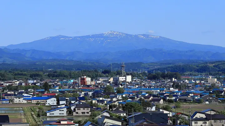
Mount Moriyoshi is a 1,454.2 m gently shaped stratovolcano in Kitaakita City, Akita Prefecture, designated as Moriyoshi-zan Prefectural Natural Park. It is included in the Nihon Nihyaku Meizan, the Ittō-Sankakuten Hyakumeizan, the Tōhoku Hyakumeizan, the Onsen Hyakumeizan, and the One Hundred Sacred Peaks of Japan. About 300 alpine plant species bloom on its slopes, and the mountain is renowned alongside Zaō and Hakkōda as one of the "Three Great Rime-Ice Mountains" (Juhyō-Sanzan). Six maintained trails reach the summit—Ani, Matsukura, Hibakura, Kometsuga, Kuroishigawa, and Komatagawa courses—and the Ani Ski Resort gondola, operated June through October, brings hikers to within an hour and forty-five minutes of the top. The summer climbing season runs May through October; the gondola also operates for winter rime-ice viewing from early January to early March.
Mount Moriyoshi at a glance
- Weather: The most settled day in the next 7 days is Wed, November 4: clear, gusts up to 12 m/s. Fri, Nov 6, Sat, Nov 7, Sun, Nov 8: strong wind (gusts up to 25 m/s).
- Route: The shortest is Mount Moriyoshi Alpine Flower Loop from the Ani Gondola Summit Station: about 3 h 13 min, 5.6 km, about 360 m of climbing.
Mount Moriyoshi weather (hourly, 14 days)
Sunrise today 06:08, sunset 16:35
| Tue, 11/3 | Wed, 11/4 | Thu, 11/5 | Fri, 11/6 | Sat, 11/7 | Sun, 11/8 | Mon, 11/9 | Tue, 11/10 | Wed, 11/11 | Thu, 11/12 | Fri, 11/13 | Sat, 11/14 | Sun, 11/15 | Mon, 11/16 | Tue, 11/17 | |||||||||||||||||||||||||||||||||||||||||||||||||||||||||||||||||||||||
|---|---|---|---|---|---|---|---|---|---|---|---|---|---|---|---|---|---|---|---|---|---|---|---|---|---|---|---|---|---|---|---|---|---|---|---|---|---|---|---|---|---|---|---|---|---|---|---|---|---|---|---|---|---|---|---|---|---|---|---|---|---|---|---|---|---|---|---|---|---|---|---|---|---|---|---|---|---|---|---|---|---|---|---|---|---|
| Japan time | 15 | 17 | 19 | 21 | 23 | 1 | 3 | 5 | 7 | 9 | 11 | 13 | 15 | 18 | 21 | 0 | 3 | 6 | 9 | 12 | 15 | 18 | 21 | 0 | 3 | 6 | 9 | 12 | 15 | 18 | 21 | 0 | 3 | 6 | 9 | 12 | 15 | 18 | 21 | 0 | 3 | 6 | 9 | 12 | 15 | 18 | 21 | 0 | 3 | 6 | 9 | 15 | 21 | 3 | 9 | 15 | 21 | 3 | 9 | 15 | 21 | 3 | 9 | 15 | 21 | 3 | 9 | 15 | 21 | 3 | 9 | 15 | 21 | 3 | 9 | 15 | 21 | 3 | 9 | 15 | 21 | 3 | 9 | 15 | |
  |   |   | |  | | | |   |  | | | | | | | |   |   |   | |   | | | | | | | | | |   | |   |   |   | |   | | | | | | |   | | | | | | |   | | | | | | | | | | | | | | | | | | | | |  | | | | | | | |   | | | | ||
| Temperature | °C | 2° | -1° | -2° | -2° | -3° | -3° | -3° | -1° | 0° | 4° | 6° | 6° | 5° | -1° | -2° | -2° | 1° | 3° | 4° | 5° | 6° | 5° | 5° | 4° | 4° | 4° | 7° | 7° | 5° | 1° | -1° | -3° | -4° | -4° | -3° | -2° | -4° | -5° | -4° | -5° | -4° | -5° | -3° | -2° | -2° | -3° | -4° | -5° | -5° | -6° | -3° | -3° | -5° | -6° | -2° | 1° | -2° | -1° | -3° | -2° | -6° | -7° | -1° | 0° | -2° | -3° | -3° | -2° | -5° | -7° | -1° | 1° | -6° | -6° | 2° | 5° | 1° | 1° | 3° | -1° | -6° | -6° | -2° | -1° |
| Precipitation | mm | 2.7 | 2.9 | 1.0 | 2.4 | 3.1 | 4.3 | 2.0 | 0.5 | 0.4 | 4.3 | 4.3 | 0.9 | 3.2 | 1.2 | 1.1 | 1.5 | 1.9 | 2.7 | 2.0 | 1.0 | 0.5 | 0.9 | 0.6 | 0.4 | 0.1 | 0.2 | 0.3 | 1.2 | 0.3 | 2.4 | 5 | 7 | 1.1 | 0.2 | 0.2 | 0.6 | 5 | 0.2 | 0.2 | 1.9 | 3.6 | 1.2 | 4.9 | 3.8 | 0.2 | |||||||||||||||||||||||||||||||||||||||
| New snow | cm | <.1 | 0.7 | 1.3 | 1.9 | 2.6 | 2.0 | 1.0 | 0.5 | 0.9 | 0.6 | 0.4 | 0.1 | 0.2 | 0.2 | 0.6 | <.1 | 1.5 | <.1 | 2.1 | 0.5 | <.1 | 0.2 | 0.1 | 0.2 | 1.5 | <.1 | ||||||||||||||||||||||||||||||||||||||||||||||||||||||||||
| Snow depth | cm | 0 | 0 | 0 | 0 | 0 | 0 | 0 | 0 | 0 | 0 | 0 | 0 | 0 | 0 | 0 | 0 | 0 | 0 | 0 | 0 | 0 | 0 | 0 | 0 | 0 | 0 | 0 | 0 | 0 | 0 | 0 | 0 | <1 | 1 | 2 | 3 | 4 | 4 | 4 | 5 | 5 | 5 | 5 | 5 | 4 | 4 | 4 | 4 | 3 | 3 | 4 | 3 | 3 | 3 | 3 | 2 | 2 | 2 | 2 | 2 | 1 | 1 | 1 | 1 | 1 | 1 | 1 | 1 | 1 | 1 | 1 | <1 | <1 | <1 | <1 | <1 | <1 | <1 | <1 | <1 | <1 | <1 | <1 | <1 |
| Wind | m/s | 5 | 2 | 2 | 1 | 1 | 1 | 1 | 3 | 2 | 4 | 3 | 3 | 2 | 1 | 2 | 2 | 3 | 4 | 5 | 3 | 1 | 1 | 0 | 1 | 2 | 1 | 2 | 4 | 5 | 4 | 5 | 4 | 4 | 4 | 6 | 8 | 5 | 5 | 5 | 5 | 5 | 5 | 6 | 7 | 6 | 4 | 3 | 2 | 2 | 1 | 2 | 3 | 1 | 1 | 1 | 3 | 6 | 1 | 3 | 3 | 1 | 1 | 3 | 3 | 1 | 1 | 4 | 5 | 2 | 1 | 2 | 2 | 1 | 2 | 2 | 2 | 3 | 2 | 1 | 4 | 4 | 2 | 2 | 2 |
| Wind gusts | m/s | 16 | 16 | 9 | 9 | 7 | 9 | 9 | 12 | 12 | 12 | 12 | 11 | 9 | 5 | 6 | 8 | 11 | 13 | 13 | 14 | 9 | 4 | 3 | 5 | 6 | 7 | 7 | 17 | 18 | 18 | 17 | 17 | 16 | 17 | 21 | 25 | 25 | 22 | 19 | 18 | 17 | 17 | 19 | 21 | 22 | 18 | 13 | 10 | 8 | 8 | 8 | 10 | 9 | 5 | 5 | 8 | 19 | 21 | 12 | 16 | 9 | 5 | 10 | 12 | 10 | 7 | 12 | 14 | 14 | 7 | 6 | 9 | 6 | 4 | 5 | 7 | 9 | 11 | 7 | 14 | 16 | 12 | 8 | 9 |
| Wind dir. | ↓ | ↓ | ↓ | ↓ | ↓ | ↓ | ↓ | ↓ | ↓ | ↓ | ↓ | ↓ | ↓ | ↓ | ↓ | ↓ | ↓ | ↓ | ↓ | ↓ | ↓ | ↓ | ↓ | ↓ | ↓ | ↓ | ↓ | ↓ | ↓ | ↓ | ↓ | ↓ | ↓ | ↓ | ↓ | ↓ | ↓ | ↓ | ↓ | ↓ | ↓ | ↓ | ↓ | ↓ | ↓ | ↓ | ↓ | ↓ | ↓ | ↓ | ↓ | ↓ | ↓ | ↓ | ↓ | ↓ | ↓ | ↓ | ↓ | ↓ | ↓ | ↓ | ↓ | ↓ | ↓ | ↓ | ↓ | ↓ | ↓ | ↓ | ↓ | ↓ | ↓ | ↓ | ↓ | ↓ | ↓ | ↓ | ↓ | ↓ | ↓ | ↓ | ↓ | ↓ | |
Mount Moriyoshi hiking routes
Hiking times are estimates calculated from the terrain.
Huts, campsites and lodging near Mount Moriyoshi
Mountain huts
- 阿仁避難小屋 unstaffed
- 森吉避難小屋
Lists that include Mount Moriyoshi
Japan 200 Famous Mountains · Japan's 300 Famous Mountains · 100 Famous Mountains with First-order Triangulation Points · 100 Famous Hot Spring Mountains · Tohoku 100 Famous Mountains · Elevations of 1003 Mountains of Japan · 1000 Mountains of Japan
Mount Moriyoshi facts
- Elevation
- 1,454 m
- Location
- Kitaakita, Akita
39.976762, 140.544180 - Website
- www.city.kitaakita.akita.jp
- Trail Map
- www.city.kitaakita.akita.jp (PDF)
- Access Information
- www.aniski.jp
- Wikipedia
- ja.wikipedia.org