
Mount Mitake
三岳山
Fukuchiyama, Kyoto · Elevation 839 m
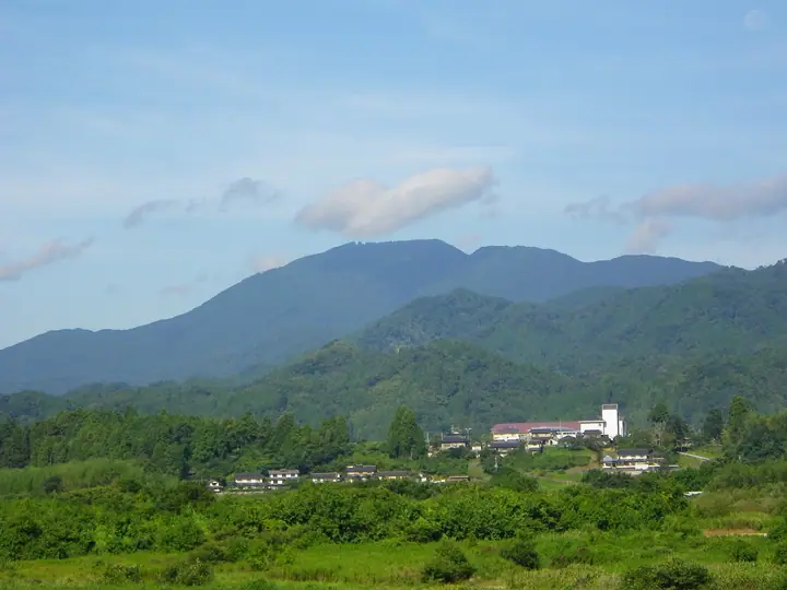
Mount Mitake is an 839.2-metre peak in northern Fukuchiyama City, Kyoto Prefecture, set in the Tango Range at the northern edge of the Tamba Highlands and the highest summit in the city. From the Heian period it was developed as a Shugendō training ground enshrining Zaō-Gongen as an outlying chapel of Enryaku-ji; Konkōji Temple at its southern foot and Mitake Shrine just below the summit still preserve that heritage, while local tradition links the mountain to Minamoto no Yorimitsu's prayers before his demon-slaying expedition to nearby Mount Ōe. It is counted among the Fukuchiyama Tourism Association's Ten Beloved Local Peaks and is listed in the Kyoto prefectural mountain guide (Bunken Tōzan Guide), Nihon no Yama 1000 and the Kyoto Prefecture 339 Mountains.
Mount Mitake at a glance
- Weather: The most settled day in the next 7 days is Wed, November 4: clear, gusts up to 9 m/s.
Mount Mitake weather (hourly, 14 days)
Sunrise today 06:22, sunset 17:04
| Tue, 11/3 | Wed, 11/4 | Thu, 11/5 | Fri, 11/6 | Sat, 11/7 | Sun, 11/8 | Mon, 11/9 | Tue, 11/10 | Wed, 11/11 | Thu, 11/12 | Fri, 11/13 | Sat, 11/14 | Sun, 11/15 | Mon, 11/16 | Tue, 11/17 | |||||||||||||||||||||||||||||||||||||||||||||||||||||||||||||||||||||||
|---|---|---|---|---|---|---|---|---|---|---|---|---|---|---|---|---|---|---|---|---|---|---|---|---|---|---|---|---|---|---|---|---|---|---|---|---|---|---|---|---|---|---|---|---|---|---|---|---|---|---|---|---|---|---|---|---|---|---|---|---|---|---|---|---|---|---|---|---|---|---|---|---|---|---|---|---|---|---|---|---|---|---|---|---|---|
| Japan time | 15 | 17 | 19 | 21 | 23 | 1 | 3 | 5 | 7 | 9 | 11 | 13 | 15 | 18 | 21 | 0 | 3 | 6 | 9 | 12 | 15 | 18 | 21 | 0 | 3 | 6 | 9 | 12 | 15 | 18 | 21 | 0 | 3 | 6 | 9 | 12 | 15 | 18 | 21 | 0 | 3 | 6 | 9 | 12 | 15 | 18 | 21 | 0 | 3 | 6 | 9 | 15 | 21 | 3 | 9 | 15 | 21 | 3 | 9 | 15 | 21 | 3 | 9 | 15 | 21 | 3 | 9 | 15 | 21 | 3 | 9 | 15 | 21 | 3 | 9 | 15 | 21 | 3 | 9 | 15 | 21 | 3 | 9 | 15 | |
  |   |   | | | | | |   |  | | | |   |   |   | | |   |   | | |   | | | | | | | | | | | | | | | | | | | | | | | | | | | | | |   | | | | | | | | | | | | | | | | |  | | | | | | | | | | | | |   | | ||
| Temperature | °C | 10° | 8° | 8° | 6° | 5° | 5° | 6° | 5° | 6° | 11° | 13° | 13° | 12° | 9° | 9° | 9° | 9° | 9° | 10° | 16° | 15° | 12° | 11° | 10° | 9° | 9° | 12° | 15° | 13° | 10° | 7° | 6° | 5° | 4° | 7° | 8° | 7° | 5° | 4° | 5° | 5° | 3° | 9° | 11° | 9° | 7° | 6° | 6° | 6° | 5° | 9° | 10° | 4° | 4° | 8° | 10° | 6° | 4° | 7° | 7° | 4° | 3° | 7° | 10° | 3° | 4° | 6° | 8° | 3° | 3° | 7° | 12° | 3° | 4° | 10° | 11° | 10° | 9° | 11° | 8° | 5° | 3° | 6° | 7° |
| Precipitation | mm | 1.1 | 0.4 | 0.8 | 0.2 | 3.4 | 1.3 | 0.8 | 0.8 | 0.5 | 3.1 | 4.5 | 0.2 | 0.2 | 0.3 | 0.2 | 1.4 | 0.2 | 0.8 | 0.1 | 0.7 | 0.5 | 0.1 | 1.5 | 0.2 | 5 | 3.5 | 0.5 | 4.5 | 1.0 | |||||||||||||||||||||||||||||||||||||||||||||||||||||||
| New snow | cm | ||||||||||||||||||||||||||||||||||||||||||||||||||||||||||||||||||||||||||||||||||||
| Snow depth | cm | 0 | 0 | 0 | 0 | 0 | 0 | 0 | 0 | 0 | 0 | 0 | 0 | 0 | 0 | 0 | 0 | 0 | 0 | 0 | 0 | 0 | 0 | 0 | 0 | 0 | 0 | 0 | 0 | 0 | 0 | 0 | 0 | 0 | 0 | 0 | 0 | 0 | 0 | 0 | 0 | 0 | 0 | 0 | 0 | 0 | 0 | 0 | 0 | 0 | 0 | 0 | 0 | 0 | 0 | 0 | 0 | 0 | 0 | 0 | 0 | 0 | 0 | 0 | 0 | 0 | 0 | 0 | 0 | 0 | 0 | 0 | 0 | 0 | 0 | 0 | 0 | 0 | 0 | 0 | 0 | 0 | 0 | 0 | 0 |
| Wind | m/s | 3 | 2 | 2 | 2 | 2 | 2 | 2 | 2 | 2 | 2 | 3 | 3 | 3 | 1 | 1 | 1 | 0 | 1 | 1 | 1 | 1 | 1 | 0 | 1 | 2 | 1 | 2 | 5 | 5 | 3 | 4 | 4 | 3 | 3 | 5 | 6 | 5 | 2 | 1 | 2 | 1 | 1 | 1 | 4 | 4 | 1 | 1 | 1 | 1 | 1 | 1 | 3 | 2 | 1 | 2 | 4 | 5 | 6 | 6 | 5 | 2 | 2 | 1 | 2 | 1 | 2 | 4 | 6 | 2 | 2 | 0 | 2 | 1 | 1 | 2 | 2 | 3 | 1 | 3 | 6 | 4 | 2 | 4 | 3 |
| Wind gusts | m/s | 7 | 6 | 4 | 4 | 4 | 4 | 4 | 5 | 5 | 6 | 8 | 9 | 9 | 7 | 2 | 3 | 4 | 2 | 3 | 4 | 4 | 2 | 2 | 4 | 6 | 5 | 7 | 11 | 13 | 12 | 8 | 9 | 8 | 8 | 12 | 14 | 14 | 12 | 4 | 4 | 4 | 3 | 4 | 10 | 11 | 9 | 3 | 3 | 3 | 3 | 4 | 10 | 9 | 4 | 5 | 12 | 11 | 16 | 16 | 15 | 12 | 4 | 4 | 6 | 6 | 5 | 10 | 13 | 13 | 5 | 5 | 5 | 5 | 4 | 5 | 10 | 9 | 8 | 8 | 13 | 13 | 9 | 9 | 9 |
| Wind dir. | ↓ | ↓ | ↓ | ↓ | ↓ | ↓ | ↓ | ↓ | ↓ | ↓ | ↓ | ↓ | ↓ | ↓ | ↓ | ↓ | ↓ | ↓ | ↓ | ↓ | ↓ | ↓ | ↓ | ↓ | ↓ | ↓ | ↓ | ↓ | ↓ | ↓ | ↓ | ↓ | ↓ | ↓ | ↓ | ↓ | ↓ | ↓ | ↓ | ↓ | ↓ | ↓ | ↓ | ↓ | ↓ | ↓ | ↓ | ↓ | ↓ | ↓ | ↓ | ↓ | ↓ | ↓ | ↓ | ↓ | ↓ | ↓ | ↓ | ↓ | ↓ | ↓ | ↓ | ↓ | ↓ | ↓ | ↓ | ↓ | ↓ | ↓ | ↓ | ↓ | ↓ | ↓ | ↓ | ↓ | ↓ | ↓ | ↓ | ↓ | ↓ | ↓ | ↓ | ↓ | |
Lists that include Mount Mitake
Mount Mitake facts
- Elevation
- 839 m
- Location
- Fukuchiyama, Kyoto
35.394114, 135.057721 - Website
- dokkoise.com
- Wikipedia
- ja.wikipedia.org