
Mount Mikagura
御神楽岳
Aga, Niigata · Elevation 1,387 m
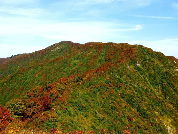
Mount Mikagura is a 1,387 m peak in the southeastern part of Aga Town in Higashi-Kanbara District, Niigata Prefecture, with its main summit on the ridge that marks the prefectural border with Fukushima within the Echigo Range. Its vertical slab walls and severe rock crests have earned it the nickname "the Tanigawa-dake of lower Echigo," and it is listed in the Nihon Nihyaku Meizan, the Tōhoku 100 Meizan, and the Echigo 100 Meizan. Three trailheads serve the peak: Muroya and Semigahira on the Niigata side, and Honna-Mikagura on the Kaneyama (Fukushima) side. The Muroya route is the gentlest, while Semigahira is a chained-rock advanced-grade traverse. The slopes carry an old-growth beech forest, and the ridge around Honna-Mikagura is designated by the Forestry Agency as part of the Mikagura-Renpo Forest Ecosystem Reserve; the climbing season generally runs from early June through November.
Mount Mikagura at a glance
- Weather: The most settled day in the next 7 days is Wed, November 4: clear, gusts up to 7 m/s. Fri, Nov 6, Sat, Nov 7, Sun, Nov 8: strong wind (gusts up to 18 m/s).
Mount Mikagura weather (hourly, 14 days)
Sunrise today 06:08, sunset 16:43
| Tue, 11/3 | Wed, 11/4 | Thu, 11/5 | Fri, 11/6 | Sat, 11/7 | Sun, 11/8 | Mon, 11/9 | Tue, 11/10 | Wed, 11/11 | Thu, 11/12 | Fri, 11/13 | Sat, 11/14 | Sun, 11/15 | Mon, 11/16 | Tue, 11/17 | |||||||||||||||||||||||||||||||||||||||||||||||||||||||||||||||||||||||
|---|---|---|---|---|---|---|---|---|---|---|---|---|---|---|---|---|---|---|---|---|---|---|---|---|---|---|---|---|---|---|---|---|---|---|---|---|---|---|---|---|---|---|---|---|---|---|---|---|---|---|---|---|---|---|---|---|---|---|---|---|---|---|---|---|---|---|---|---|---|---|---|---|---|---|---|---|---|---|---|---|---|---|---|---|---|
| Japan time | 15 | 17 | 19 | 21 | 23 | 1 | 3 | 5 | 7 | 9 | 11 | 13 | 15 | 18 | 21 | 0 | 3 | 6 | 9 | 12 | 15 | 18 | 21 | 0 | 3 | 6 | 9 | 12 | 15 | 18 | 21 | 0 | 3 | 6 | 9 | 12 | 15 | 18 | 21 | 0 | 3 | 6 | 9 | 12 | 15 | 18 | 21 | 0 | 3 | 6 | 9 | 15 | 21 | 3 | 9 | 15 | 21 | 3 | 9 | 15 | 21 | 3 | 9 | 15 | 21 | 3 | 9 | 15 | 21 | 3 | 9 | 15 | 21 | 3 | 9 | 15 | 21 | 3 | 9 | 15 | 21 | 3 | 9 | 15 | |
  |   | |  | | | | |  | | | | | |   |   |   | |   |   | | |   | | | | | |   | | | | | | |   |   | | | | | |   | | | | | | | | |   | | | | | |   | | | | | | | | | | | | | | |  | | | | | | | | | | | | ||
| Temperature | °C | 6° | 1° | -1° | -2° | -3° | -3° | -3° | -3° | -2° | 5° | 7° | 8° | 8° | 3° | 2° | 2° | 2° | 3° | 5° | 7° | 9° | 5° | 5° | 5° | 4° | 5° | 8° | 9° | 8° | 5° | 3° | 1° | 0° | -1° | -2° | -1° | -1° | -2° | -2° | -2° | -2° | -2° | 1° | 2° | 1° | -1° | -2° | -1° | -2° | -2° | 1° | 1° | -2° | -5° | 1° | 6° | 0° | -3° | 0° | 1° | -1° | -2° | 1° | 3° | -3° | -1° | 0° | 1° | -2° | -3° | 2° | 5° | -4° | -6° | 3° | 7° | 2° | 2° | 5° | 3° | -2° | -2° | 0° | 1° |
| Precipitation | mm | 6 | 12 | 2.0 | 2.5 | 0.1 | 0.1 | 0.3 | 1.0 | 0.9 | 2.2 | 0.6 | 1.8 | 1.9 | 4.1 | 4.2 | 4.6 | 3.6 | 3.0 | 2.3 | 0.7 | 0.4 | 0.9 | 1.2 | 0.7 | 0.1 | 0.5 | 0.2 | 0.1 | 0.4 | 0.7 | 0.9 | 0.1 | 1.2 | 9 | 4.2 | 4.2 | 2.0 | 0.6 | 0.1 | 0.6 | 1.9 | 6 | 0.1 | 3.8 | 6 | 1.6 | 8 | 4.8 | ||||||||||||||||||||||||||||||||||||
| New snow | cm | 0.2 | <.1 | 0.3 | 1.2 | ||||||||||||||||||||||||||||||||||||||||||||||||||||||||||||||||||||||||||||||||
| Snow depth | cm | 0 | 0 | 0 | 0 | 0 | 0 | 0 | 0 | 0 | 0 | 0 | 0 | 0 | 0 | 0 | 0 | 0 | 0 | 0 | 0 | 0 | 0 | 0 | 0 | 0 | 0 | 0 | 0 | 0 | 0 | 0 | 0 | 0 | 0 | 0 | 0 | 0 | 0 | 0 | 0 | 0 | 0 | 0 | 0 | 0 | 0 | 0 | 0 | 0 | 0 | 0 | 0 | 0 | 0 | 0 | 0 | 0 | <1 | <1 | 0 | 0 | 0 | 0 | 0 | 0 | 0 | 0 | 0 | 0 | 0 | 0 | 0 | 0 | 0 | 0 | 0 | 0 | 0 | 0 | 0 | 0 | 0 | 0 | 0 |
| Wind | m/s | 4 | 1 | 1 | 2 | 2 | 2 | 2 | 2 | 2 | 0 | 1 | 2 | 3 | 2 | 2 | 2 | 2 | 1 | 1 | 1 | 1 | 1 | 1 | 1 | 1 | 1 | 4 | 5 | 5 | 4 | 4 | 3 | 3 | 4 | 4 | 5 | 5 | 4 | 4 | 4 | 4 | 4 | 5 | 5 | 3 | 2 | 1 | 2 | 2 | 1 | 1 | 3 | 2 | 1 | 1 | 4 | 1 | 3 | 5 | 5 | 2 | 2 | 2 | 4 | 2 | 2 | 4 | 5 | 2 | 2 | 1 | 2 | 1 | 2 | 1 | 1 | 1 | 1 | 1 | 6 | 5 | 3 | 2 | 3 |
| Wind gusts | m/s | 11 | 9 | 4 | 5 | 5 | 5 | 5 | 5 | 4 | 4 | 5 | 6 | 7 | 7 | 5 | 6 | 6 | 5 | 5 | 5 | 5 | 3 | 3 | 3 | 4 | 6 | 11 | 16 | 16 | 15 | 13 | 11 | 12 | 13 | 15 | 17 | 18 | 16 | 13 | 13 | 13 | 12 | 13 | 15 | 13 | 9 | 5 | 5 | 5 | 4 | 4 | 10 | 8 | 5 | 4 | 12 | 11 | 13 | 15 | 20 | 16 | 6 | 5 | 11 | 10 | 7 | 12 | 15 | 13 | 6 | 5 | 6 | 6 | 5 | 5 | 5 | 4 | 4 | 6 | 16 | 16 | 13 | 8 | 8 |
| Wind dir. | ↓ | ↓ | ↓ | ↓ | ↓ | ↓ | ↓ | ↓ | ↓ | ↓ | ↓ | ↓ | ↓ | ↓ | ↓ | ↓ | ↓ | ↓ | ↓ | ↓ | ↓ | ↓ | ↓ | ↓ | ↓ | ↓ | ↓ | ↓ | ↓ | ↓ | ↓ | ↓ | ↓ | ↓ | ↓ | ↓ | ↓ | ↓ | ↓ | ↓ | ↓ | ↓ | ↓ | ↓ | ↓ | ↓ | ↓ | ↓ | ↓ | ↓ | ↓ | ↓ | ↓ | ↓ | ↓ | ↓ | ↓ | ↓ | ↓ | ↓ | ↓ | ↓ | ↓ | ↓ | ↓ | ↓ | ↓ | ↓ | ↓ | ↓ | ↓ | ↓ | ↓ | ↓ | ↓ | ↓ | ↓ | ↓ | ↓ | ↓ | ↓ | ↓ | ↓ | ↓ | |
Huts, campsites and lodging near Mount Mikagura
Mountain huts
Lists that include Mount Mikagura
Japan 200 Famous Mountains · Japan's 300 Famous Mountains · Tohoku 100 Famous Mountains · Koshinetsu 100 Famous Mountains · Niigata 100 Famous Mountains · Elevations of 1003 Mountains of Japan · 1000 Mountains of Japan
Mount Mikagura facts
- Elevation
- 1,387 m
- Location
- Aga, Niigata
37.521887, 139.425876 - Website
- www.town.aga.niigata.jp
- Access Information
- niigata-kankou.or.jp
- Wikipedia
- ja.wikipedia.org