
Mount Konbu
昆布岳
Niseko, Hokkaido · Elevation 1,045 m
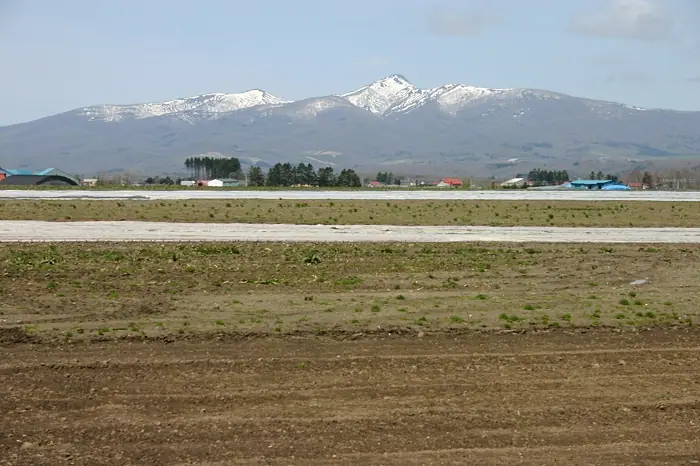
Mount Konbu is a 1,045.1 m late-Pliocene volcano on the boundary between Toyoura Town and Niseko Town in Hokkaido, distinguished by a stubby rock knob projecting from its summit. Its Ainu name 'Tokonpo-nupuri' means 'small knob mountain', and the modern kanji name evolved from an early phonetic transcription 'Konpodake' that drifted into 'Konbudake'. The one-way Toyoura trail to the summit is about 5.7 km and takes around three hours, with sweeping views from the top over Mount Usu, Lake Tōya, and Mount Yōtei. It is one of the 100 Famous Mountains of Hokkaido.
Mount Konbu at a glance
- Weather: The most settled day in the next 7 days is Thu, November 5: clear, gusts up to 5 m/s. Fri, Nov 6, Sat, Nov 7, Sun, Nov 8: strong wind (gusts up to 21 m/s).
Mount Konbu weather (hourly, 14 days)
Sunrise today 06:13, sunset 16:29
| Tue, 11/3 | Wed, 11/4 | Thu, 11/5 | Fri, 11/6 | Sat, 11/7 | Sun, 11/8 | Mon, 11/9 | Tue, 11/10 | Wed, 11/11 | Thu, 11/12 | Fri, 11/13 | Sat, 11/14 | Sun, 11/15 | Mon, 11/16 | Tue, 11/17 | |||||||||||||||||||||||||||||||||||||||||||||||||||||||||||||||||||||||
|---|---|---|---|---|---|---|---|---|---|---|---|---|---|---|---|---|---|---|---|---|---|---|---|---|---|---|---|---|---|---|---|---|---|---|---|---|---|---|---|---|---|---|---|---|---|---|---|---|---|---|---|---|---|---|---|---|---|---|---|---|---|---|---|---|---|---|---|---|---|---|---|---|---|---|---|---|---|---|---|---|---|---|---|---|---|
| Japan time | 21 | 23 | 1 | 3 | 5 | 7 | 9 | 11 | 13 | 15 | 17 | 19 | 21 | 0 | 3 | 6 | 9 | 12 | 15 | 18 | 21 | 0 | 3 | 6 | 9 | 12 | 15 | 18 | 21 | 0 | 3 | 6 | 9 | 12 | 15 | 18 | 21 | 0 | 3 | 6 | 9 | 12 | 15 | 18 | 21 | 0 | 3 | 6 | 9 | 12 | 15 | 21 | 3 | 9 | 15 | 21 | 3 | 9 | 15 | 21 | 3 | 9 | 15 | 21 | 3 | 9 | 15 | 21 | 3 | 9 | 15 | 21 | 3 | 9 | 15 | 21 | 3 | 9 | 15 | 21 | 3 | 9 | 15 | 21 | |
  |   | |   |   |   |   |  | | |  | | |   |   | | | | |   |   | | | |   |   | | |   | | | |   | | | | | | | | | | | | | | | | | |   | | |   | | | | | | | | |   | | | | | | | | | | | | | | | | | | |   | | | ||
| Temperature | °C | -4° | -5° | -6° | -4° | -4° | -3° | -1° | 0° | 1° | 0° | -4° | -5° | -5° | -7° | -6° | -6° | 2° | 5° | 6° | 2° | 1° | 2° | 2° | 2° | 5° | 8° | 4° | -1° | -4° | -6° | -7° | -7° | -6° | -5° | -6° | -5° | -6° | -6° | -6° | -7° | -6° | -5° | -5° | -6° | -8° | -8° | -8° | -9° | -7° | -6° | -7° | -11° | -9° | -6° | -5° | -11° | -9° | -5° | -2° | -9° | -9° | -4° | -3° | -8° | -9° | -7° | -6° | -8° | -10° | -4° | -2° | -8° | -5° | -1° | 1° | -1° | -1° | -3° | -4° | -8° | -9° | -3° | -3° | -6° |
| Precipitation | mm | 0.4 | 2.2 | 3.0 | 1.1 | 0.1 | 0.6 | 2.0 | 1.2 | 2.5 | 1.1 | 0.3 | 1.4 | 0.4 | 0.5 | 1.0 | 1.0 | 1.1 | 1.4 | 1.6 | 1.5 | 1.6 | 1.1 | 1.0 | 1.3 | 1.7 | 1.3 | 0.7 | 0.3 | 0.2 | 0.1 | 0.1 | 0.3 | 0.4 | 0.3 | 0.3 | 0.1 | 1.1 | 1.1 | 0.7 | 0.8 | 0.2 | 0.2 | 0.1 | 0.5 | 0.9 | 1.0 | 2.4 | 3.8 | 1.0 | |||||||||||||||||||||||||||||||||||
| New snow | cm | 0.4 | 2.0 | 2.9 | 0.1 | 0.2 | 1.0 | 1.0 | 1.1 | 1.4 | 1.6 | 1.5 | 1.6 | 1.1 | 1.0 | 1.3 | 1.7 | 1.3 | 0.7 | 0.3 | 0.2 | <.1 | <.1 | 0.1 | 0.1 | 0.3 | 0.4 | 0.1 | <.1 | 0.3 | 0.1 | 1.1 | 1.1 | 0.7 | 0.7 | 0.2 | 0.2 | <.1 | <.1 | 0.2 | <.1 | ||||||||||||||||||||||||||||||||||||||||||||
| Snow depth | cm | <1 | 1 | 3 | 3 | 3 | 3 | 3 | 2 | 2 | 1 | <1 | <1 | <1 | <1 | <1 | <1 | <1 | <1 | <1 | <1 | <1 | 0 | 0 | 0 | 0 | 0 | 0 | 0 | 0 | <1 | 1 | 2 | 3 | 4 | 5 | 6 | 6 | 7 | 7 | 8 | 8 | 9 | 10 | 10 | 10 | 10 | 10 | 10 | 10 | 10 | 9 | 9 | 9 | 10 | 9 | 9 | 10 | 11 | 10 | 10 | 10 | 10 | 10 | 10 | 10 | 10 | 10 | 10 | 10 | 10 | 9 | 9 | 9 | 8 | 5 | 5 | 4 | 3 | 3 | 3 | 3 | 3 | 3 | 3 |
| Wind | m/s | 1 | 1 | 1 | 2 | 3 | 3 | 4 | 2 | 1 | 1 | 0 | 0 | 0 | 0 | 0 | 0 | 0 | 1 | 1 | 0 | 0 | 0 | 0 | 0 | 1 | 4 | 4 | 4 | 4 | 5 | 5 | 4 | 5 | 7 | 6 | 7 | 6 | 6 | 6 | 5 | 5 | 6 | 4 | 2 | 1 | 1 | 1 | 1 | 2 | 4 | 3 | 1 | 1 | 0 | 2 | 1 | 2 | 1 | 2 | 0 | 1 | 1 | 3 | 2 | 1 | 5 | 4 | 1 | 1 | 0 | 1 | 0 | 1 | 0 | 1 | 1 | 0 | 2 | 4 | 2 | 1 | 1 | 2 | 1 |
| Wind gusts | m/s | 7 | 6 | 8 | 10 | 11 | 11 | 11 | 11 | 7 | 5 | 4 | 3 | 3 | 3 | 3 | 3 | 3 | 4 | 5 | 3 | 6 | 5 | 4 | 3 | 4 | 12 | 16 | 17 | 12 | 14 | 14 | 14 | 15 | 20 | 21 | 22 | 20 | 18 | 18 | 17 | 15 | 16 | 17 | 12 | 8 | 6 | 5 | 5 | 7 | 10 | 10 | 9 | 5 | 4 | 6 | 6 | 5 | 5 | 8 | 6 | 5 | 5 | 12 | 9 | 6 | 13 | 14 | 11 | 5 | 4 | 5 | 3 | 5 | 5 | 6 | 6 | 4 | 6 | 12 | 13 | 7 | 6 | 8 | 6 |
| Wind dir. | ↓ | ↓ | ↓ | ↓ | ↓ | ↓ | ↓ | ↓ | ↓ | ↓ | ↓ | ↓ | ↓ | ↓ | ↓ | ↓ | ↓ | ↓ | ↓ | ↓ | ↓ | ↓ | ↓ | ↓ | ↓ | ↓ | ↓ | ↓ | ↓ | ↓ | ↓ | ↓ | ↓ | ↓ | ↓ | ↓ | ↓ | ↓ | ↓ | ↓ | ↓ | ↓ | ↓ | ↓ | ↓ | ↓ | ↓ | ↓ | ↓ | ↓ | ↓ | ↓ | ↓ | ↓ | ↓ | ↓ | ↓ | ↓ | ↓ | ↓ | ↓ | ↓ | ↓ | ↓ | ↓ | ↓ | ↓ | ↓ | ↓ | ↓ | ↓ | ↓ | ↓ | ↓ | ↓ | ↓ | ↓ | ↓ | ↓ | ↓ | ↓ | ↓ | ↓ | ↓ | |
Lists that include Mount Konbu
Hokkaido 100 Famous Mountains · Elevations of 1003 Mountains of Japan
Mount Konbu facts
- Also known as
- トコンポヌプリ
- Elevation
- 1,045 m
- Location
- Niseko, Hokkaido
42.710361, 140.655481 - Website
- www.town.toyoura.hokkaido.jp
- Trail Map
- www.town.toyoura.hokkaido.jp (PDF)
- Access Information
- www.town.toyoura.hokkaido.jp (PDF)
- Wikipedia
- ja.wikipedia.org