
Mount Kasa
笠山
Ogawa, Saitama / Higashichichibu, Saitama · Elevation 837 m
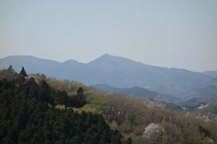
Mount Kasa (837 m) stands on the border between Ogawa Town and Higashi-Chichibu Village in Saitama Prefecture, forming one of the Hiki Three Mountains together with Mount Dōdaira and Mount Ōgiri on the main spine of the Outer Chichibu range. Its symmetrical conical profile, visible from the Kantō Plain, gives rise to the nickname Nyūbō-san ('breast mountain'); the summit is split into two small peaks, with Kasayama Shrine enshrined on the slightly higher eastern peak (842 m). Trails climb from Kaiya via Kasayama Pass and continue south to Mount Dōdaira, and the peak is a featured summit on the Outer-Chichibu Seven Peaks traverse.
Mount Kasa at a glance
- Weather: The most settled day in the next 7 days is Fri, November 6: clear, gusts up to 6 m/s.
Mount Kasa weather (hourly, 14 days)
Sunrise today 06:07, sunset 16:47
| Tue, 11/3 | Wed, 11/4 | Thu, 11/5 | Fri, 11/6 | Sat, 11/7 | Sun, 11/8 | Mon, 11/9 | Tue, 11/10 | Wed, 11/11 | Thu, 11/12 | Fri, 11/13 | Sat, 11/14 | Sun, 11/15 | Mon, 11/16 | Tue, 11/17 | |||||||||||||||||||||||||||||||||||||||||||||||||||||||||||||||||||||||
|---|---|---|---|---|---|---|---|---|---|---|---|---|---|---|---|---|---|---|---|---|---|---|---|---|---|---|---|---|---|---|---|---|---|---|---|---|---|---|---|---|---|---|---|---|---|---|---|---|---|---|---|---|---|---|---|---|---|---|---|---|---|---|---|---|---|---|---|---|---|---|---|---|---|---|---|---|---|---|---|---|---|---|---|---|---|
| Japan time | 15 | 17 | 19 | 21 | 23 | 1 | 3 | 5 | 7 | 9 | 11 | 13 | 15 | 18 | 21 | 0 | 3 | 6 | 9 | 12 | 15 | 18 | 21 | 0 | 3 | 6 | 9 | 12 | 15 | 18 | 21 | 0 | 3 | 6 | 9 | 12 | 15 | 18 | 21 | 0 | 3 | 6 | 9 | 12 | 15 | 18 | 21 | 0 | 3 | 6 | 9 | 15 | 21 | 3 | 9 | 15 | 21 | 3 | 9 | 15 | 21 | 3 | 9 | 15 | 21 | 3 | 9 | 15 | 21 | 3 | 9 | 15 | 21 | 3 | 9 | 15 | 21 | 3 | 9 | 15 | 21 | 3 | 9 | 15 | |
  |   |   | | |   | | |   | | | | | | | | | |   |   |   |   |   | | |  |  | | | | | | | | | | | | | | | | | | | | | | | | | |   | | | | | | | | |  | | | | | | | | | | | | | | | | | | | | | | | ||
| Temperature | °C | 13° | 10° | 10° | 9° | 8° | 8° | 7° | 7° | 7° | 10° | 11° | 11° | 10° | 8° | 8° | 7° | 7° | 7° | 10° | 16° | 13° | 11° | 9° | 8° | 7° | 7° | 15° | 19° | 19° | 12° | 10° | 8° | 7° | 5° | 10° | 12° | 11° | 5° | 3° | 2° | 2° | 1° | 7° | 11° | 10° | 5° | 6° | 5° | 3° | 4° | 6° | 8° | 5° | 4° | 6° | 9° | 5° | 2° | 9° | 10° | 3° | 0° | 7° | 10° | 5° | 1° | 10° | 9° | 2° | -1° | 5° | 8° | 1° | 0° | 6° | 10° | 6° | 6° | 13° | 15° | 7° | 3° | 6° | 7° |
| Precipitation | mm | 0.4 | 0.1 | 0.2 | 0.2 | 3.9 | 11 | 14 | 2.2 | 0.9 | 0.8 | 0.3 | 0.2 | 1.5 | 0.2 | 1.7 | 10 | ||||||||||||||||||||||||||||||||||||||||||||||||||||||||||||||||||||
| New snow | cm | ||||||||||||||||||||||||||||||||||||||||||||||||||||||||||||||||||||||||||||||||||||
| Snow depth | cm | 0 | 0 | 0 | 0 | 0 | 0 | 0 | 0 | 0 | 0 | 0 | 0 | 0 | 0 | 0 | 0 | 0 | 0 | 0 | 0 | 0 | 0 | 0 | 0 | 0 | 0 | 0 | 0 | 0 | 0 | 0 | 0 | 0 | 0 | 0 | 0 | 0 | 0 | 0 | 0 | 0 | 0 | 0 | 0 | 0 | 0 | 0 | 0 | 0 | 0 | 0 | 0 | 0 | 0 | 0 | 0 | 0 | 0 | 0 | 0 | 0 | 0 | 0 | 0 | 0 | 0 | 0 | 0 | 0 | 0 | 0 | 0 | 0 | 0 | 0 | 0 | 0 | 0 | 0 | 0 | 0 | 0 | 0 | 0 |
| Wind | m/s | 2 | 2 | 1 | 0 | 0 | 1 | 1 | 1 | 0 | 1 | 2 | 2 | 2 | 1 | 2 | 2 | 2 | 2 | 3 | 1 | 1 | 0 | 1 | 2 | 1 | 1 | 1 | 1 | 1 | 2 | 2 | 2 | 3 | 3 | 4 | 5 | 4 | 1 | 2 | 2 | 2 | 2 | 2 | 2 | 3 | 2 | 1 | 1 | 1 | 1 | 1 | 1 | 0 | 0 | 1 | 3 | 1 | 2 | 7 | 5 | 2 | 2 | 1 | 2 | 1 | 1 | 3 | 5 | 2 | 2 | 1 | 2 | 1 | 2 | 1 | 0 | 1 | 1 | 1 | 4 | 4 | 2 | 1 | 2 |
| Wind gusts | m/s | 7 | 5 | 4 | 3 | 1 | 2 | 2 | 2 | 1 | 4 | 6 | 7 | 7 | 5 | 3 | 4 | 4 | 5 | 5 | 6 | 4 | 3 | 3 | 4 | 4 | 3 | 4 | 5 | 6 | 4 | 6 | 6 | 8 | 8 | 9 | 12 | 12 | 9 | 4 | 4 | 6 | 6 | 7 | 7 | 8 | 8 | 4 | 3 | 3 | 3 | 3 | 6 | 4 | 3 | 4 | 7 | 7 | 4 | 18 | 18 | 13 | 6 | 5 | 7 | 6 | 3 | 8 | 13 | 11 | 6 | 5 | 7 | 6 | 4 | 4 | 5 | 4 | 4 | 5 | 13 | 13 | 10 | 5 | 7 |
| Wind dir. | ↓ | ↓ | ↓ | ↓ | ↓ | ↓ | ↓ | ↓ | ↓ | ↓ | ↓ | ↓ | ↓ | ↓ | ↓ | ↓ | ↓ | ↓ | ↓ | ↓ | ↓ | ↓ | ↓ | ↓ | ↓ | ↓ | ↓ | ↓ | ↓ | ↓ | ↓ | ↓ | ↓ | ↓ | ↓ | ↓ | ↓ | ↓ | ↓ | ↓ | ↓ | ↓ | ↓ | ↓ | ↓ | ↓ | ↓ | ↓ | ↓ | ↓ | ↓ | ↓ | ↓ | ↓ | ↓ | ↓ | ↓ | ↓ | ↓ | ↓ | ↓ | ↓ | ↓ | ↓ | ↓ | ↓ | ↓ | ↓ | ↓ | ↓ | ↓ | ↓ | ↓ | ↓ | ↓ | ↓ | ↓ | ↓ | ↓ | ↓ | ↓ | ↓ | ↓ | ↓ | |
Huts, campsites and lodging near Mount Kasa
Campsites
- 白石キャンプ村
- 堂平天文台 星と緑の創造センター
- 木のむらキャンプ場
Lodging
- 都幾川温泉 とき川
Lists that include Mount Kasa
100 Low Mountains of Japan · Kanto 100 Famous Mountains · 50 Mountains of Saitama Prefecture · Tokigawa 10 Peaks · 1000 Mountains of Japan
Mount Kasa facts
- Also known as
- 笠山東峰 · 乳房山
- Elevation
- 837 m
- Location
- Ogawa, Saitama / Higashichichibu, Saitama
36.018498, 139.189863 - Wikipedia
- ja.wikipedia.org