
Mount Bukō
武甲山
Yokoze, Saitama / Chichibu, Saitama · Elevation 1,304 m
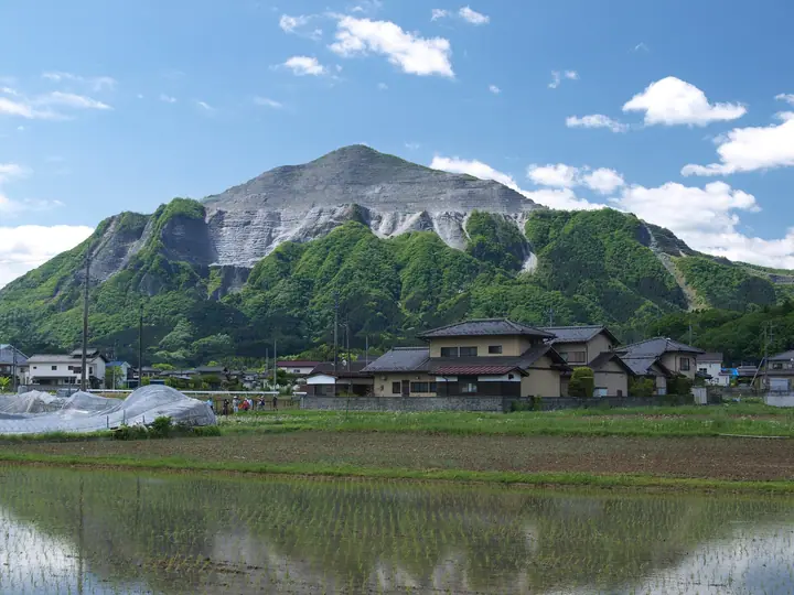
Mount Bukō is a 1,304 m limestone peak straddling Chichibu City and Yokoze Town in Saitama Prefecture, an iconic landmark rising over the Chichibu Basin. The summit is home to Bukōzan Mitake Shrine, where the annual yamabiraki opening ceremony is held on 1 May, and the mountain has long been revered in local mountain worship. Its northern face has been heavily quarried for limestone, leaving the distinctive sculpted profile visible from the basin. Listed in the Nihon Nihyaku Meizan, the Hana no Hyakumeizan, the Kantō Hyakumeizan, and the Nihon Hyaku Teizan, the mountain is known for limestone-loving wildflowers such as Setsubun-sō, Katakuri, and Chichibu-iwazakura. The standard route is the Omote-sandō from the Ichi-no-Torii (Nōkawa) trailhead on the Yokoze side via Fudō-no-Taki and Ōsugi-no-Hiroba, reaching the summit in about two hours. Yokoze's tourism association currently marks the descent via the Chōja-yashiki ridge toward Urayamaguchi Station as impassable.
Mount Bukō at a glance
- Weather: The most settled day in the next 7 days is Fri, November 6: clear, gusts up to 7 m/s.
- Route: The shortest is Mount Buko, Mount Komochi and Mount Omochi Circuit from Ichinotorii: about 4 h 4 min, 10.1 km, about 1,130 m of climbing.
Mount Bukō weather (hourly, 14 days)
Sunrise today 06:07, sunset 16:47
| Tue, 11/3 | Wed, 11/4 | Thu, 11/5 | Fri, 11/6 | Sat, 11/7 | Sun, 11/8 | Mon, 11/9 | Tue, 11/10 | Wed, 11/11 | Thu, 11/12 | Fri, 11/13 | Sat, 11/14 | Sun, 11/15 | Mon, 11/16 | Tue, 11/17 | |||||||||||||||||||||||||||||||||||||||||||||||||||||||||||||||||||||||
|---|---|---|---|---|---|---|---|---|---|---|---|---|---|---|---|---|---|---|---|---|---|---|---|---|---|---|---|---|---|---|---|---|---|---|---|---|---|---|---|---|---|---|---|---|---|---|---|---|---|---|---|---|---|---|---|---|---|---|---|---|---|---|---|---|---|---|---|---|---|---|---|---|---|---|---|---|---|---|---|---|---|---|---|---|---|
| Japan time | 15 | 17 | 19 | 21 | 23 | 1 | 3 | 5 | 7 | 9 | 11 | 13 | 15 | 18 | 21 | 0 | 3 | 6 | 9 | 12 | 15 | 18 | 21 | 0 | 3 | 6 | 9 | 12 | 15 | 18 | 21 | 0 | 3 | 6 | 9 | 12 | 15 | 18 | 21 | 0 | 3 | 6 | 9 | 12 | 15 | 18 | 21 | 0 | 3 | 6 | 9 | 15 | 21 | 3 | 9 | 15 | 21 | 3 | 9 | 15 | 21 | 3 | 9 | 15 | 21 | 3 | 9 | 15 | 21 | 3 | 9 | 15 | 21 | 3 | 9 | 15 | 21 | 3 | 9 | 15 | 21 | 3 | 9 | 15 | |
  |   | |   | | | | | | | | | | | | | | |   |   |   |   | |   |  | |  |   |   | | | | | | | | | | | | | | | | |   | | | | | | | | | | | | | | |   |  | | | | | | | | | | | | | | | | | | | | | | | ||
| Temperature | °C | 8° | 6° | 6° | 6° | 5° | 4° | 4° | 4° | 4° | 5° | 7° | 7° | 6° | 4° | 4° | 4° | 4° | 5° | 7° | 13° | 10° | 8° | 5° | 5° | 5° | 6° | 12° | 16° | 14° | 9° | 6° | 4° | 2° | 1° | 7° | 10° | 8° | 2° | 0° | -1° | -2° | -3° | 4° | 8° | 6° | 2° | 2° | 1° | 0° | 1° | 3° | 5° | 2° | 1° | 2° | 5° | 1° | -3° | 4° | 5° | -1° | -3° | 4° | 5° | 2° | -2° | 7° | 6° | -3° | -4° | 3° | 5° | -1° | -3° | 4° | 6° | 4° | 4° | 11° | 12° | 3° | 0° | 1° | 4° |
| Precipitation | mm | 0.3 | 0.6 | 0.9 | 0.2 | 0.4 | 0.5 | 5 | 12 | 13 | 1.9 | 1.0 | 0.6 | 0.5 | 0.4 | 2.1 | 0.5 | 0.2 | 3.3 | 13 | |||||||||||||||||||||||||||||||||||||||||||||||||||||||||||||||||
| New snow | cm | ||||||||||||||||||||||||||||||||||||||||||||||||||||||||||||||||||||||||||||||||||||
| Snow depth | cm | 0 | 0 | 0 | 0 | 0 | 0 | 0 | 0 | 0 | 0 | 0 | 0 | 0 | 0 | 0 | 0 | 0 | 0 | 0 | 0 | 0 | 0 | 0 | 0 | 0 | 0 | 0 | 0 | 0 | 0 | 0 | 0 | 0 | 0 | 0 | 0 | 0 | 0 | 0 | 0 | 0 | 0 | 0 | 0 | 0 | 0 | 0 | 0 | 0 | 0 | 0 | 0 | 0 | 0 | 0 | 0 | 0 | 0 | 0 | 0 | 0 | 0 | 0 | 0 | 0 | 0 | 0 | 0 | 0 | 0 | 0 | 0 | 0 | 0 | 0 | 0 | 0 | 0 | 0 | 0 | 0 | 0 | 0 | 0 |
| Wind | m/s | 1 | 0 | 0 | 0 | 1 | 1 | 0 | 0 | 1 | 1 | 2 | 2 | 2 | 1 | 0 | 1 | 1 | 1 | 2 | 1 | 2 | 0 | 1 | 1 | 1 | 1 | 0 | 2 | 2 | 0 | 1 | 1 | 1 | 1 | 2 | 3 | 3 | 0 | 0 | 0 | 1 | 0 | 1 | 2 | 2 | 0 | 0 | 0 | 0 | 0 | 2 | 1 | 1 | 2 | 2 | 3 | 1 | 2 | 7 | 6 | 1 | 1 | 1 | 1 | 1 | 2 | 4 | 4 | 1 | 1 | 1 | 2 | 1 | 1 | 1 | 2 | 0 | 0 | 1 | 5 | 3 | 0 | 1 | 2 |
| Wind gusts | m/s | 6 | 4 | 2 | 2 | 2 | 3 | 3 | 2 | 3 | 4 | 5 | 6 | 6 | 6 | 5 | 3 | 3 | 5 | 5 | 6 | 5 | 4 | 3 | 3 | 3 | 3 | 4 | 6 | 7 | 5 | 3 | 4 | 4 | 4 | 6 | 10 | 10 | 10 | 2 | 2 | 3 | 3 | 5 | 6 | 7 | 6 | 3 | 3 | 3 | 3 | 5 | 7 | 5 | 5 | 6 | 9 | 8 | 5 | 22 | 21 | 16 | 5 | 4 | 8 | 5 | 5 | 11 | 15 | 12 | 5 | 5 | 7 | 6 | 3 | 4 | 7 | 4 | 5 | 5 | 14 | 14 | 10 | 5 | 7 |
| Wind dir. | ↓ | ↓ | ↓ | ↓ | ↓ | ↓ | ↓ | ↓ | ↓ | ↓ | ↓ | ↓ | ↓ | ↓ | ↓ | ↓ | ↓ | ↓ | ↓ | ↓ | ↓ | ↓ | ↓ | ↓ | ↓ | ↓ | ↓ | ↓ | ↓ | ↓ | ↓ | ↓ | ↓ | ↓ | ↓ | ↓ | ↓ | ↓ | ↓ | ↓ | ↓ | ↓ | ↓ | ↓ | ↓ | ↓ | ↓ | ↓ | ↓ | ↓ | ↓ | ↓ | ↓ | ↓ | ↓ | ↓ | ↓ | ↓ | ↓ | ↓ | ↓ | ↓ | ↓ | ↓ | ↓ | ↓ | ↓ | ↓ | ↓ | ↓ | ↓ | ↓ | ↓ | ↓ | ↓ | ↓ | ↓ | ↓ | ↓ | ↓ | ↓ | ↓ | ↓ | ↓ | |
Mount Bukō hiking routes
- Mount Buko, Mount Komochi and Mount Omochi Circuit from Ichinotorii 10.1 km · Ascent 1,132 m parking
- Mount Buko Omotesando and Shirajikubo Loop 6.9 km · Ascent 771 m parking
- Yokoze Station to Urayamaguchi Station via Ichinotorii and Mount Buko 15.5 km · Ascent 1,065 m Yokoze (Station) (parking) → 浦山口駅 (Station), Urayamaguchi (Station)
Hiking times are estimates calculated from the terrain.
Huts, campsites and lodging near Mount Bukō
Campsites
- hashitachikawa camping ground
Lodging
- 舎場〈ヤドリバ〉シンワ
- 御宿 竹取物語
- HOTEL ROUTE-INN CHICHIBU
- 丸山鉱泉旅館
Lists that include Mount Bukō
Japan 200 Famous Mountains · Japan's 300 Famous Mountains · 100 Famous Mountains of Flowers · 100 Low Mountains of Japan · Illustrated Collection of Japan's Famous Mountains · Kanto 100 Famous Mountains · 50 Mountains of Saitama Prefecture · Elevations of 1003 Mountains of Japan · 1000 Mountains of Japan
Mount Bukō facts
- Also known as
- 秩父嶺 · 秩父嶽 · 御嵩 · 岳山 · 秩父山 · 蔵王山 · 乳首山 · 妙見山
- Elevation
- 1,304 m
- Location
- Yokoze, Saitama / Chichibu, Saitama
35.951612, 139.097777 - Season Opens
- May 1
- Website
- www.yokoze.org
- Trail Map
- www.yokoze.org
- Wikipedia
- ja.wikipedia.org