
Mount Kamui
カムイヌプリ
Teshikaga, Hokkaido · Elevation 845 m
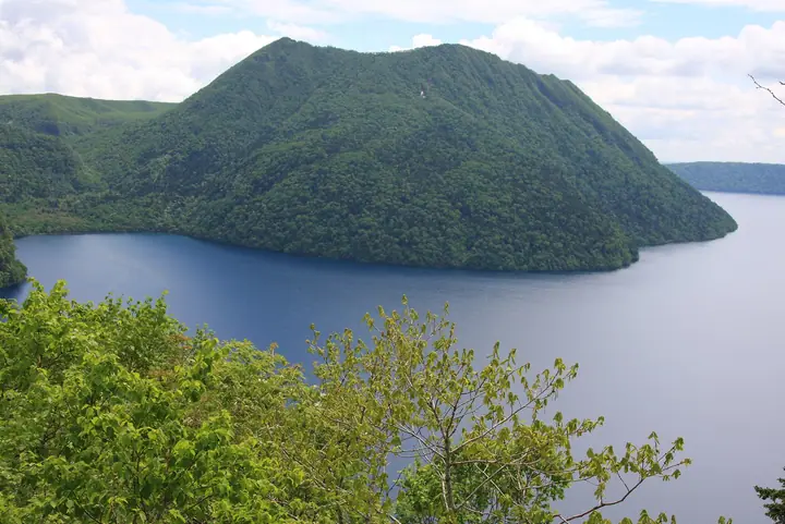
Also known as Mount Mashu, its Ainu name means mountain of the gods. This small stratovolcano stands on the southeastern wall of the Mashu caldera, with a large explosion crater formed in an eruption about 1000 years ago. The 7.2 km trail from Lake Mashu’s First Observatory follows the southern caldera rim. Alpine flower fields and summit views of the lake and crater are highlights.
Mount Kamui at a glance
- Weather: The most settled day in the next 7 days is Thu, November 5: cloudy, gusts up to 13 m/s. Wed, Nov 4, Sat, Nov 7, Sun, Nov 8: strong wind (gusts up to 22 m/s).
- Route: The shortest is Lake Mashu First Observatory–Mount Mashu Return: about 7 h 39 min, 14.0 km, about 680 m of climbing.
Mount Kamui weather (hourly, 14 days)
Sunrise today 05:59, sunset 16:12
| Tue, 11/3 | Wed, 11/4 | Thu, 11/5 | Fri, 11/6 | Sat, 11/7 | Sun, 11/8 | Mon, 11/9 | Tue, 11/10 | Wed, 11/11 | Thu, 11/12 | Fri, 11/13 | Sat, 11/14 | Sun, 11/15 | Mon, 11/16 | Tue, 11/17 | |||||||||||||||||||||||||||||||||||||||||||||||||||||||||||||||||||||||
|---|---|---|---|---|---|---|---|---|---|---|---|---|---|---|---|---|---|---|---|---|---|---|---|---|---|---|---|---|---|---|---|---|---|---|---|---|---|---|---|---|---|---|---|---|---|---|---|---|---|---|---|---|---|---|---|---|---|---|---|---|---|---|---|---|---|---|---|---|---|---|---|---|---|---|---|---|---|---|---|---|---|---|---|---|---|
| Japan time | 21 | 23 | 1 | 3 | 5 | 7 | 9 | 11 | 13 | 15 | 17 | 19 | 21 | 0 | 3 | 6 | 9 | 12 | 15 | 18 | 21 | 0 | 3 | 6 | 9 | 12 | 15 | 18 | 21 | 0 | 3 | 6 | 9 | 12 | 15 | 18 | 21 | 0 | 3 | 6 | 9 | 12 | 15 | 18 | 21 | 0 | 3 | 6 | 9 | 12 | 15 | 21 | 3 | 9 | 15 | 21 | 3 | 9 | 15 | 21 | 3 | 9 | 15 | 21 | 3 | 9 | 15 | 21 | 3 | 9 | 15 | 21 | 3 | 9 | 15 | 21 | 3 | 9 | 15 | 21 | 3 | 9 | 15 | 21 | |
 | |   | |   |  | |   |   | |  | | | | | | |   |   |   | | | | | | | | | | | | | | |   | | | | | | | | | | |   | |   | |   | |   | | | | | |   | | | | | | | | | |   | | | |  | | | | |   | | |   | | | | | ||
| Temperature | °C | -2° | -3° | -4° | -4° | -2° | -1° | 3° | 3° | 4° | 4° | 0° | -2° | -2° | -2° | -2° | -3° | 6° | 7° | 7° | 6° | 5° | 6° | 5° | 5° | 6° | 6° | 6° | 6° | 5° | 1° | 0° | -2° | 0° | 2° | 0° | -2° | -2° | -2° | -2° | -1° | 0° | 1° | 1° | -2° | -3° | -4° | -4° | -4° | -2° | -1° | -2° | -4° | -5° | -2° | -1° | -4° | -3° | -1° | 1° | -4° | -4° | 0° | 1° | -2° | -3° | -4° | -2° | -4° | -3° | -1° | -1° | -4° | -4° | 1° | 3° | 1° | 2° | 2° | -1° | -3° | -4° | -2° | -1° | -3° |
| Precipitation | mm | 0.1 | 0.7 | 0.9 | 2.0 | 1.8 | 3.7 | 2.8 | 1.9 | 0.5 | 0.1 | 1.5 | 0.4 | 0.1 | 0.2 | 0.5 | 0.2 | 1.8 | 1.3 | 1.1 | 0.8 | ||||||||||||||||||||||||||||||||||||||||||||||||||||||||||||||||
| New snow | cm | 0.1 | <.1 | <.1 | 0.4 | <.1 | 0.1 | 0.5 | <.1 | <.1 | <.1 | 0.2 | 0.8 | <.1 | |||||||||||||||||||||||||||||||||||||||||||||||||||||||||||||||||||||||
| Snow depth | cm | 0 | 0 | 0 | 0 | 0 | 0 | 0 | 0 | 0 | 0 | 0 | 0 | 0 | 0 | 0 | 0 | 0 | 0 | 0 | 0 | 0 | 0 | 0 | 0 | 0 | 0 | 0 | 0 | 0 | 0 | 0 | 0 | 0 | 0 | 0 | 0 | 0 | 0 | 0 | 0 | 0 | 0 | 0 | 0 | 0 | 0 | 0 | 0 | 0 | 0 | 0 | 0 | 0 | 0 | 0 | 0 | 0 | 0 | 0 | 0 | 0 | 0 | 0 | 0 | 0 | 0 | 0 | <1 | 0 | <1 | 0 | 0 | 0 | 0 | 0 | 0 | 0 | 0 | 0 | 0 | <1 | <1 | <1 | <1 |
| Wind | m/s | 4 | 2 | 1 | 2 | 2 | 2 | 7 | 7 | 6 | 3 | 1 | 2 | 2 | 1 | 1 | 1 | 5 | 3 | 3 | 2 | 2 | 2 | 2 | 3 | 2 | 2 | 3 | 3 | 4 | 4 | 5 | 5 | 6 | 7 | 7 | 4 | 3 | 3 | 5 | 7 | 9 | 10 | 8 | 5 | 4 | 3 | 3 | 2 | 3 | 0 | 3 | 3 | 3 | 3 | 2 | 1 | 1 | 1 | 2 | 1 | 1 | 1 | 2 | 4 | 6 | 6 | 5 | 8 | 8 | 6 | 5 | 1 | 1 | 2 | 3 | 2 | 2 | 4 | 8 | 8 | 5 | 7 | 3 | 0 |
| Wind gusts | m/s | 8 | 8 | 4 | 5 | 6 | 6 | 16 | 18 | 16 | 13 | 7 | 4 | 4 | 5 | 5 | 5 | 12 | 13 | 10 | 7 | 5 | 5 | 6 | 7 | 6 | 6 | 6 | 7 | 9 | 10 | 12 | 13 | 13 | 17 | 17 | 15 | 9 | 9 | 13 | 16 | 20 | 22 | 22 | 17 | 13 | 10 | 8 | 7 | 7 | 7 | 8 | 9 | 8 | 7 | 7 | 6 | 3 | 5 | 8 | 4 | 2 | 4 | 5 | 10 | 13 | 14 | 15 | 20 | 19 | 17 | 15 | 11 | 3 | 6 | 9 | 6 | 6 | 8 | 16 | 17 | 17 | 15 | 15 | 6 |
| Wind dir. | ↓ | ↓ | ↓ | ↓ | ↓ | ↓ | ↓ | ↓ | ↓ | ↓ | ↓ | ↓ | ↓ | ↓ | ↓ | ↓ | ↓ | ↓ | ↓ | ↓ | ↓ | ↓ | ↓ | ↓ | ↓ | ↓ | ↓ | ↓ | ↓ | ↓ | ↓ | ↓ | ↓ | ↓ | ↓ | ↓ | ↓ | ↓ | ↓ | ↓ | ↓ | ↓ | ↓ | ↓ | ↓ | ↓ | ↓ | ↓ | ↓ | ↓ | ↓ | ↓ | ↓ | ↓ | ↓ | ↓ | ↓ | ↓ | ↓ | ↓ | ↓ | ↓ | ↓ | ↓ | ↓ | ↓ | ↓ | ↓ | ↓ | ↓ | ↓ | ↓ | ↓ | ↓ | ↓ | ↓ | ↓ | ↓ | ↓ | ↓ | ↓ | ↓ | ↓ | ↓ | |
Mount Kamui hiking routes
Hiking times are estimates calculated from the terrain.
Mount Kamui facts
- Also known as
- Kamuinupuri
- Elevation
- 845 m
- Location
- Teshikaga, Hokkaido
43.574468, 144.555455 - Volcano
- Active volcano (摩周)
- Website
- www.kawayu-eco-museum.com
- Trail Map
- www.kawayu-eco-museum.com (PDF)
- Wikipedia
- ja.wikipedia.org