
Atosanupuri
アトサヌプリ
Teshikaga, Hokkaido · Elevation 508 m
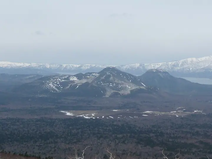
Atosanupuri is a 508 m active volcano in Teshikaga, Hokkaido, on the eastern rim of the Kussharo caldera within Akan-Mashu National Park. Its Ainu name means bare mountain. More than 1500 fumaroles continually emit sulfur-bearing steam, and the volcano supplies Kawayu Onsen. At its base, an unusually low-elevation colony of Ezo-isotsutsuji, normally found in dwarf-pine zones, blooms in early summer. A volcanic alert system operates here. Most of the mountain is legally restricted under ecotourism legislation, so visitors cannot climb freely, but can observe its volcanic terrain from the trail between Tsutsujigahara and Sulfur Mountain and on treks led by town-certified guides.
Atosanupuri at a glance
- Weather: The most settled day in the next 7 days is Mon, November 9: cloudy, gusts up to 10 m/s. Wed, Nov 4, Sat, Nov 7, Sun, Nov 8: strong wind (gusts up to 16 m/s).
Atosanupuri weather (hourly, 14 days)
Sunrise today 05:59, sunset 16:12
| Tue, 11/3 | Wed, 11/4 | Thu, 11/5 | Fri, 11/6 | Sat, 11/7 | Sun, 11/8 | Mon, 11/9 | Tue, 11/10 | Wed, 11/11 | Thu, 11/12 | Fri, 11/13 | Sat, 11/14 | Sun, 11/15 | Mon, 11/16 | Tue, 11/17 | |||||||||||||||||||||||||||||||||||||||||||||||||||||||||||||||||||||||
|---|---|---|---|---|---|---|---|---|---|---|---|---|---|---|---|---|---|---|---|---|---|---|---|---|---|---|---|---|---|---|---|---|---|---|---|---|---|---|---|---|---|---|---|---|---|---|---|---|---|---|---|---|---|---|---|---|---|---|---|---|---|---|---|---|---|---|---|---|---|---|---|---|---|---|---|---|---|---|---|---|---|---|---|---|---|
| Japan time | 15 | 17 | 19 | 21 | 23 | 1 | 3 | 5 | 7 | 9 | 11 | 13 | 15 | 18 | 21 | 0 | 3 | 6 | 9 | 12 | 15 | 18 | 21 | 0 | 3 | 6 | 9 | 12 | 15 | 18 | 21 | 0 | 3 | 6 | 9 | 12 | 15 | 18 | 21 | 0 | 3 | 6 | 9 | 12 | 15 | 18 | 21 | 0 | 3 | 6 | 9 | 15 | 21 | 3 | 9 | 15 | 21 | 3 | 9 | 15 | 21 | 3 | 9 | 15 | 21 | 3 | 9 | 15 | 21 | 3 | 9 | 15 | 21 | 3 | 9 | 15 | 21 | 3 | 9 | 15 | 21 | 3 | 9 | 15 | |
 |  | | | |   |   | | |   |   |   | |  | | | | | | | |   |   | | | |   | | | | | | | | | | | | | | | | | | | | | | | | | | |   | | | | |   | | | |   | |   | | | |   | | | |  | | | | |   | |   |   |   | | | ||
| Temperature | °C | 2° | -1° | -1° | -1° | -2° | -2° | -2° | -1° | 1° | 3° | 4° | 4° | 4° | 0° | 0° | -1° | -1° | -1° | 7° | 9° | 8° | 7° | 6° | 7° | 7° | 7° | 7° | 7° | 8° | 7° | 6° | 2° | 0° | -2° | 1° | 2° | 1° | -2° | -2° | -2° | -3° | -2° | 0° | 1° | 1° | -1° | -2° | -2° | -3° | -4° | 0° | 1° | -3° | -4° | -1° | 0° | -3° | -3° | -1° | 1° | -2° | -2° | 1° | 2° | -1° | -3° | -3° | -1° | -3° | -3° | -1° | 0° | -2° | -3° | 2° | 4° | 2° | 3° | 3° | 0° | -2° | -3° | -1° | 0° |
| Precipitation | mm | 2.4 | 2.8 | 0.7 | 1.0 | 0.1 | 1.2 | 0.3 | 0.2 | 0.4 | 0.1 | 0.3 | 0.1 | 0.2 | 0.2 | 1.0 | 0.2 | 2.2 | 3.4 | 2.0 | 1.5 | ||||||||||||||||||||||||||||||||||||||||||||||||||||||||||||||||
| New snow | cm | 0.4 | <.1 | 0.2 | 0.1 | 0.2 | 0.2 | 1.0 | <.1 | <.1 | <.1 | 0.5 | 0.8 | 1.5 | <.1 | ||||||||||||||||||||||||||||||||||||||||||||||||||||||||||||||||||||||
| Snow depth | cm | 0 | 0 | 0 | 0 | 0 | 0 | 0 | 0 | 0 | 0 | 0 | 0 | 0 | 0 | 0 | 0 | 0 | 0 | 0 | 0 | 0 | 0 | 0 | 0 | 0 | 0 | 0 | 0 | 0 | 0 | 0 | 0 | 0 | 0 | 0 | 0 | 0 | 0 | 0 | 0 | 0 | 0 | 0 | 0 | 0 | 0 | 0 | 0 | 0 | 0 | 0 | 0 | 0 | 0 | 0 | 0 | 0 | 0 | 0 | 0 | 0 | 0 | 0 | 0 | 0 | <1 | <1 | <1 | <1 | <1 | <1 | <1 | <1 | <1 | <1 | <1 | <1 | 0 | 0 | <1 | 1 | 2 | 2 | 1 |
| Wind | m/s | 4 | 3 | 2 | 3 | 1 | 1 | 2 | 3 | 2 | 7 | 7 | 5 | 3 | 1 | 2 | 2 | 2 | 2 | 3 | 4 | 4 | 3 | 2 | 2 | 3 | 3 | 3 | 3 | 3 | 3 | 2 | 4 | 3 | 3 | 4 | 7 | 4 | 3 | 1 | 2 | 1 | 3 | 6 | 6 | 5 | 5 | 4 | 3 | 1 | 1 | 4 | 3 | 2 | 2 | 2 | 2 | 1 | 1 | 1 | 2 | 1 | 0 | 1 | 2 | 3 | 4 | 5 | 5 | 6 | 6 | 5 | 4 | 0 | 1 | 3 | 3 | 3 | 2 | 3 | 5 | 6 | 5 | 6 | 2 |
| Wind gusts | m/s | 12 | 10 | 6 | 7 | 6 | 3 | 6 | 7 | 6 | 14 | 16 | 16 | 12 | 7 | 4 | 5 | 5 | 6 | 8 | 10 | 11 | 9 | 6 | 6 | 7 | 7 | 7 | 8 | 11 | 8 | 6 | 10 | 10 | 8 | 10 | 15 | 16 | 10 | 7 | 5 | 5 | 8 | 14 | 16 | 16 | 14 | 12 | 10 | 7 | 3 | 9 | 10 | 8 | 6 | 6 | 7 | 6 | 2 | 4 | 5 | 4 | 2 | 5 | 5 | 7 | 10 | 12 | 14 | 18 | 14 | 14 | 12 | 9 | 3 | 7 | 8 | 6 | 6 | 7 | 12 | 15 | 14 | 14 | 13 |
| Wind dir. | ↓ | ↓ | ↓ | ↓ | ↓ | ↓ | ↓ | ↓ | ↓ | ↓ | ↓ | ↓ | ↓ | ↓ | ↓ | ↓ | ↓ | ↓ | ↓ | ↓ | ↓ | ↓ | ↓ | ↓ | ↓ | ↓ | ↓ | ↓ | ↓ | ↓ | ↓ | ↓ | ↓ | ↓ | ↓ | ↓ | ↓ | ↓ | ↓ | ↓ | ↓ | ↓ | ↓ | ↓ | ↓ | ↓ | ↓ | ↓ | ↓ | ↓ | ↓ | ↓ | ↓ | ↓ | ↓ | ↓ | ↓ | ↓ | ↓ | ↓ | ↓ | ↓ | ↓ | ↓ | ↓ | ↓ | ↓ | ↓ | ↓ | ↓ | ↓ | ↓ | ↓ | ↓ | ↓ | ↓ | ↓ | ↓ | ↓ | ↓ | ↓ | ↓ | ↓ | ↓ | |
Atosanupuri live cameras
Huts, campsites and lodging near Atosanupuri
Lodging
- Parkway Hotel
- ホテルパークウェイ Hotel Parkway
- あさ寝坊 Asanebou
- 川湯観光ホテル
- ホテル川湯パーク
Lists that include Atosanupuri
Elevations of 1003 Mountains of Japan · 1000 Mountains of Japan
Atosanupuri facts
- Also known as
- 硫黄山 · 川湯硫黄山 · Mount Io
- Elevation
- 508 m
- Location
- Teshikaga, Hokkaido
43.610407, 144.438640 - National Park
- 阿寒摩周国立公園
- Volcano
- Active volcano (アトサヌプリ)
- Website
- www.env.go.jp
- Wikipedia
- ja.wikipedia.org