
Mount Nishibetsu
西別岳
Shibecha, Hokkaido · Elevation 800 m
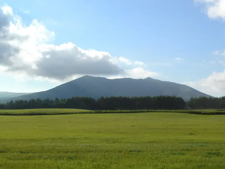
Mount Nishibetsu (800 m) rises in Shibecha Town in eastern Hokkaido, southeast of Lake Mashu within Akan-Mashu National Park. Mist drifting from the lake supports rich alpine flora at this low elevation, with flowers blooming from spring into autumn. The relatively short trail from Nishibetsu Hut includes the steep Gamanzaka slope, but remains a popular climb attempted by beginners, with sweeping views of Lake Mashu and Mount Mashu. The ascent covers 3.2 km and takes 1 hour 30 minutes.
Mount Nishibetsu at a glance
- Weather: The most settled day in the next 7 days is Thu, November 5: cloudy, gusts up to 13 m/s. Wed, Nov 4, Sat, Nov 7, Sun, Nov 8: strong wind (gusts up to 22 m/s).
- Route: The shortest is Mount Nishibetsu and Mount Risuke Out-and-Back: about 3 h 59 min, 6.5 km, about 550 m of climbing.
Mount Nishibetsu weather (hourly, 14 days)
Sunrise today 05:59, sunset 16:12
| Tue, 11/3 | Wed, 11/4 | Thu, 11/5 | Fri, 11/6 | Sat, 11/7 | Sun, 11/8 | Mon, 11/9 | Tue, 11/10 | Wed, 11/11 | Thu, 11/12 | Fri, 11/13 | Sat, 11/14 | Sun, 11/15 | Mon, 11/16 | Tue, 11/17 | |||||||||||||||||||||||||||||||||||||||||||||||||||||||||||||||||||||||
|---|---|---|---|---|---|---|---|---|---|---|---|---|---|---|---|---|---|---|---|---|---|---|---|---|---|---|---|---|---|---|---|---|---|---|---|---|---|---|---|---|---|---|---|---|---|---|---|---|---|---|---|---|---|---|---|---|---|---|---|---|---|---|---|---|---|---|---|---|---|---|---|---|---|---|---|---|---|---|---|---|---|---|---|---|---|
| Japan time | 21 | 23 | 1 | 3 | 5 | 7 | 9 | 11 | 13 | 15 | 17 | 19 | 21 | 0 | 3 | 6 | 9 | 12 | 15 | 18 | 21 | 0 | 3 | 6 | 9 | 12 | 15 | 18 | 21 | 0 | 3 | 6 | 9 | 12 | 15 | 18 | 21 | 0 | 3 | 6 | 9 | 12 | 15 | 18 | 21 | 0 | 3 | 6 | 9 | 12 | 15 | 21 | 3 | 9 | 15 | 21 | 3 | 9 | 15 | 21 | 3 | 9 | 15 | 21 | 3 | 9 | 15 | 21 | 3 | 9 | 15 | 21 | 3 | 9 | 15 | 21 | 3 | 9 | 15 | 21 | 3 | 9 | 15 | 21 | |
 | |   | |   |  | |   |   | |  | | | | | | |   |   |   | | | | | | | | | | | | | | |   | | | | | | | | | | |   | |   | |   | |   | | | | | |   | | | | | | | | | |   | | | |  | | | | |   | | |   | | | | | ||
| Temperature | °C | -1° | -2° | -4° | -4° | -2° | 0° | 3° | 4° | 4° | 4° | 0° | -2° | -2° | -2° | -2° | -2° | 6° | 8° | 7° | 6° | 6° | 6° | 6° | 6° | 6° | 6° | 7° | 6° | 6° | 2° | 0° | -2° | 0° | 2° | 0° | -2° | -2° | -2° | -1° | -1° | 1° | 2° | 1° | -1° | -2° | -3° | -4° | -4° | -1° | -1° | -2° | -3° | -4° | -2° | 0° | -4° | -3° | -1° | 1° | -3° | -4° | 0° | 1° | -1° | -3° | -3° | -2° | -3° | -3° | -1° | -1° | -3° | -4° | 1° | 3° | 2° | 2° | 3° | -1° | -2° | -3° | -2° | 0° | -3° |
| Precipitation | mm | 0.1 | 0.7 | 0.9 | 2.0 | 1.8 | 3.7 | 2.8 | 1.9 | 0.5 | 0.1 | 1.5 | 0.4 | 0.1 | 0.2 | 0.5 | 0.2 | 1.8 | 1.3 | 1.1 | 0.8 | ||||||||||||||||||||||||||||||||||||||||||||||||||||||||||||||||
| New snow | cm | 0.1 | <.1 | <.1 | 0.4 | <.1 | 0.1 | 0.5 | <.1 | <.1 | <.1 | 0.2 | 0.8 | <.1 | |||||||||||||||||||||||||||||||||||||||||||||||||||||||||||||||||||||||
| Snow depth | cm | 0 | 0 | 0 | 0 | 0 | 0 | 0 | 0 | 0 | 0 | 0 | 0 | 0 | 0 | 0 | 0 | 0 | 0 | 0 | 0 | 0 | 0 | 0 | 0 | 0 | 0 | 0 | 0 | 0 | 0 | 0 | 0 | 0 | 0 | 0 | 0 | 0 | 0 | 0 | 0 | 0 | 0 | 0 | 0 | 0 | 0 | 0 | 0 | 0 | 0 | 0 | 0 | 0 | 0 | 0 | 0 | 0 | 0 | 0 | 0 | 0 | 0 | 0 | 0 | 0 | 0 | 0 | <1 | 0 | <1 | 0 | 0 | 0 | 0 | 0 | 0 | 0 | 0 | 0 | 0 | <1 | <1 | <1 | <1 |
| Wind | m/s | 4 | 2 | 1 | 2 | 2 | 2 | 7 | 7 | 6 | 3 | 1 | 2 | 2 | 1 | 1 | 1 | 5 | 3 | 3 | 2 | 2 | 2 | 2 | 3 | 2 | 2 | 3 | 3 | 4 | 4 | 5 | 5 | 6 | 7 | 7 | 4 | 3 | 3 | 5 | 7 | 9 | 10 | 8 | 5 | 4 | 3 | 3 | 2 | 3 | 0 | 3 | 3 | 3 | 3 | 2 | 1 | 1 | 1 | 2 | 1 | 1 | 1 | 2 | 4 | 6 | 6 | 5 | 8 | 8 | 6 | 5 | 1 | 1 | 2 | 3 | 2 | 2 | 4 | 8 | 8 | 5 | 7 | 3 | 0 |
| Wind gusts | m/s | 8 | 8 | 4 | 5 | 6 | 6 | 16 | 18 | 16 | 13 | 7 | 4 | 4 | 5 | 5 | 5 | 12 | 13 | 10 | 7 | 5 | 5 | 6 | 7 | 6 | 6 | 6 | 7 | 9 | 10 | 12 | 13 | 13 | 17 | 17 | 15 | 9 | 9 | 13 | 16 | 20 | 22 | 22 | 17 | 13 | 10 | 8 | 7 | 7 | 7 | 8 | 9 | 8 | 7 | 7 | 6 | 3 | 5 | 8 | 4 | 2 | 4 | 5 | 10 | 13 | 14 | 15 | 20 | 19 | 17 | 15 | 11 | 3 | 6 | 9 | 6 | 6 | 8 | 16 | 17 | 17 | 15 | 15 | 6 |
| Wind dir. | ↓ | ↓ | ↓ | ↓ | ↓ | ↓ | ↓ | ↓ | ↓ | ↓ | ↓ | ↓ | ↓ | ↓ | ↓ | ↓ | ↓ | ↓ | ↓ | ↓ | ↓ | ↓ | ↓ | ↓ | ↓ | ↓ | ↓ | ↓ | ↓ | ↓ | ↓ | ↓ | ↓ | ↓ | ↓ | ↓ | ↓ | ↓ | ↓ | ↓ | ↓ | ↓ | ↓ | ↓ | ↓ | ↓ | ↓ | ↓ | ↓ | ↓ | ↓ | ↓ | ↓ | ↓ | ↓ | ↓ | ↓ | ↓ | ↓ | ↓ | ↓ | ↓ | ↓ | ↓ | ↓ | ↓ | ↓ | ↓ | ↓ | ↓ | ↓ | ↓ | ↓ | ↓ | ↓ | ↓ | ↓ | ↓ | ↓ | ↓ | ↓ | ↓ | ↓ | ↓ | |
Mount Nishibetsu hiking routes
Hiking times are estimates calculated from the terrain.
Huts, campsites and lodging near Mount Nishibetsu
Mountain huts
Lists that include Mount Nishibetsu
Mount Nishibetsu facts
- Elevation
- 800 m
- Location
- Shibecha, Hokkaido
43.553513, 144.581805 - National Park
- 阿寒摩周国立公園
- Website
- www.env.go.jp
- Trail Map
- hokkaido.env.go.jp (PDF)
- Wikipedia
- ja.wikipedia.org