
Mount Kakuda
角田山
Niigata, Niigata · Elevation 482 m
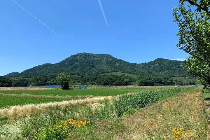
Mount Kakuda is a 482 m peak at the northern end of the Yahiko range in Nishikan Ward, Niigata City. Part of the Sado-Yahiko-Yoneyama Quasi-National Park, it is celebrated as one of Japan's premier flower mountains for its spring carpets of yukiwariso (liverleaf) and katakuri, and appears on lists such as Shin-Hana no Hyakumeizan and Echigo Hyakuzan. Seven trails reach the summit, including a dramatic route up the Sea of Japan coast past the Kakuda lighthouse.
Mount Kakuda at a glance
- Weather: The most settled day in the next 7 days is Wed, November 4: clear, gusts up to 9 m/s. Fri, Nov 6, Sat, Nov 7: strong wind (gusts up to 22 m/s).
- Route: The shortest is Mount Kakuda Return via the Tojima Trail: about 2 h 23 min, 3.4 km, about 420 m of climbing.
Mount Kakuda weather (hourly, 14 days)
Sunrise today 06:11, sunset 16:45
| Tue, 11/3 | Wed, 11/4 | Thu, 11/5 | Fri, 11/6 | Sat, 11/7 | Sun, 11/8 | Mon, 11/9 | Tue, 11/10 | Wed, 11/11 | Thu, 11/12 | Fri, 11/13 | Sat, 11/14 | Sun, 11/15 | Mon, 11/16 | Tue, 11/17 | |||||||||||||||||||||||||||||||||||||||||||||||||||||||||||||||||||||||
|---|---|---|---|---|---|---|---|---|---|---|---|---|---|---|---|---|---|---|---|---|---|---|---|---|---|---|---|---|---|---|---|---|---|---|---|---|---|---|---|---|---|---|---|---|---|---|---|---|---|---|---|---|---|---|---|---|---|---|---|---|---|---|---|---|---|---|---|---|---|---|---|---|---|---|---|---|---|---|---|---|---|---|---|---|---|
| Japan time | 15 | 17 | 19 | 21 | 23 | 1 | 3 | 5 | 7 | 9 | 11 | 13 | 15 | 18 | 21 | 0 | 3 | 6 | 9 | 12 | 15 | 18 | 21 | 0 | 3 | 6 | 9 | 12 | 15 | 18 | 21 | 0 | 3 | 6 | 9 | 12 | 15 | 18 | 21 | 0 | 3 | 6 | 9 | 12 | 15 | 18 | 21 | 0 | 3 | 6 | 9 | 15 | 21 | 3 | 9 | 15 | 21 | 3 | 9 | 15 | 21 | 3 | 9 | 15 | 21 | 3 | 9 | 15 | 21 | 3 | 9 | 15 | 21 | 3 | 9 | 15 | 21 | 3 | 9 | 15 | 21 | 3 | 9 | 15 | |
  |   | | | | | | | | | |  | | | |   |   | |   |   |   | | | | |   |   | | | |   | | | | | | | | | | |   | | |   | | | | | | | | | | | | | | | | | | | | | | | | | | | |  | | | | | | | | | | | | ||
| Temperature | °C | 12° | 10° | 8° | 8° | 7° | 7° | 6° | 6° | 6° | 11° | 13° | 14° | 14° | 12° | 11° | 11° | 10° | 10° | 11° | 12° | 15° | 13° | 13° | 12° | 13° | 14° | 14° | 16° | 14° | 12° | 10° | 8° | 8° | 7° | 8° | 8° | 8° | 8° | 7° | 7° | 7° | 8° | 9° | 8° | 9° | 7° | 6° | 7° | 6° | 6° | 7° | 7° | 6° | 3° | 7° | 13° | 10° | 7° | 8° | 9° | 8° | 7° | 8° | 10° | 7° | 9° | 8° | 8° | 7° | 6° | 8° | 10° | 5° | 3° | 9° | 14° | 8° | 9° | 12° | 10° | 7° | 6° | 6° | 8° |
| Precipitation | mm | 2.2 | 8 | 4.6 | 1.2 | 1.1 | 1.3 | 0.5 | 1.8 | 2.2 | 0.6 | 1.0 | 0.9 | 0.2 | 1.4 | 1.1 | 0.7 | 0.4 | 0.5 | 0.8 | 0.4 | 0.3 | 0.5 | 0.3 | 0.4 | 0.7 | 1.6 | 1.2 | 0.3 | 1.1 | 0.2 | 9 | 17 | 2.7 | 2.4 | 1.0 | 0.1 | 0.8 | 0.8 | 0.3 | 5 | 1.4 | 3.5 | 2.2 | 10 | 5 | 0.2 | ||||||||||||||||||||||||||||||||||||||
| New snow | cm | ||||||||||||||||||||||||||||||||||||||||||||||||||||||||||||||||||||||||||||||||||||
| Snow depth | cm | 0 | 0 | 0 | 0 | 0 | 0 | 0 | 0 | 0 | 0 | 0 | 0 | 0 | 0 | 0 | 0 | 0 | 0 | 0 | 0 | 0 | 0 | 0 | 0 | 0 | 0 | 0 | 0 | 0 | 0 | 0 | 0 | 0 | 0 | 0 | 0 | 0 | 0 | 0 | 0 | 0 | 0 | 0 | 0 | 0 | 0 | 0 | 0 | 0 | 0 | 0 | 0 | 0 | 0 | 0 | 0 | 0 | 0 | 0 | 0 | 0 | 0 | 0 | 0 | 0 | 0 | 0 | 0 | 0 | 0 | 0 | 0 | 0 | 0 | 0 | 0 | 0 | 0 | 0 | 0 | 0 | 0 | 0 | 0 |
| Wind | m/s | 2 | 2 | 1 | 1 | 2 | 2 | 2 | 2 | 3 | 3 | 2 | 4 | 5 | 5 | 3 | 5 | 3 | 3 | 2 | 2 | 1 | 0 | 2 | 2 | 3 | 6 | 7 | 9 | 10 | 8 | 5 | 6 | 7 | 8 | 11 | 11 | 10 | 10 | 9 | 8 | 8 | 7 | 6 | 5 | 4 | 2 | 1 | 1 | 2 | 2 | 2 | 5 | 2 | 2 | 4 | 5 | 7 | 9 | 9 | 9 | 5 | 2 | 2 | 5 | 5 | 6 | 7 | 5 | 3 | 1 | 3 | 2 | 2 | 1 | 2 | 1 | 4 | 2 | 2 | 10 | 7 | 3 | 1 | 3 |
| Wind gusts | m/s | 6 | 6 | 4 | 2 | 3 | 4 | 4 | 4 | 5 | 5 | 6 | 8 | 9 | 9 | 8 | 8 | 8 | 6 | 5 | 5 | 5 | 3 | 4 | 4 | 6 | 11 | 14 | 17 | 20 | 18 | 16 | 11 | 14 | 15 | 20 | 22 | 22 | 19 | 18 | 17 | 16 | 15 | 13 | 12 | 10 | 7 | 3 | 3 | 4 | 5 | 5 | 12 | 10 | 4 | 8 | 9 | 17 | 17 | 19 | 20 | 16 | 8 | 6 | 10 | 9 | 11 | 16 | 14 | 11 | 6 | 7 | 7 | 5 | 3 | 4 | 5 | 7 | 7 | 8 | 18 | 19 | 12 | 5 | 6 |
| Wind dir. | ↓ | ↓ | ↓ | ↓ | ↓ | ↓ | ↓ | ↓ | ↓ | ↓ | ↓ | ↓ | ↓ | ↓ | ↓ | ↓ | ↓ | ↓ | ↓ | ↓ | ↓ | ↓ | ↓ | ↓ | ↓ | ↓ | ↓ | ↓ | ↓ | ↓ | ↓ | ↓ | ↓ | ↓ | ↓ | ↓ | ↓ | ↓ | ↓ | ↓ | ↓ | ↓ | ↓ | ↓ | ↓ | ↓ | ↓ | ↓ | ↓ | ↓ | ↓ | ↓ | ↓ | ↓ | ↓ | ↓ | ↓ | ↓ | ↓ | ↓ | ↓ | ↓ | ↓ | ↓ | ↓ | ↓ | ↓ | ↓ | ↓ | ↓ | ↓ | ↓ | ↓ | ↓ | ↓ | ↓ | ↓ | ↓ | ↓ | ↓ | ↓ | ↓ | ↓ | ↓ | |
Mount Kakuda hiking routes
- Mount Kakuda Return via the Tojima Trail 3.4 km · Ascent 422 m 稲島登山口 (parking)
- Nishikan, Niigata, Mount Kakuda of the Snow-break Flowers, Gentlest Return by the Gokatoge Trail 6.2 km · Ascent 401 m 角田山 五ヶ峠コース駐車場
- Mount Kakuda Return via the Fukui Hotaru-no-Sato Trail 5.9 km · Ascent 545 m ほたるの里コース登山口, ほたるの里第1駐車場 (parking)
- Mount Kakuda Sakura Ridge and Lighthouse Loop 6.5 km · Ascent 603 m 此の入沢コース登山口 (parking) → parking
Hiking times are estimates calculated from the terrain.
Huts, campsites and lodging near Mount Kakuda
Campsites
- 角田浜キャンプ場
Lodging
- 民宿/海の家[福助茶屋]
- Yumotoya Onsen Ryokan
- 高島屋
- 岩室温泉富士屋
- メイワサンピア
Lists that include Mount Kakuda
New 100 Famous Flower Mountains · Niigata 100 Famous Mountains
Mount Kakuda facts
- Elevation
- 482 m
- Location
- Niigata, Niigata
37.780459, 138.836986 - National Park
- 佐渡弥彦米山国定公園
- Website
- www.city.niigata.lg.jp
- Trail Map
- www.city.niigata.lg.jp (PDF)
- Wikipedia
- ja.wikipedia.org