
Mount Ikoma
生駒山
Ikoma, Nara · Elevation 642 m
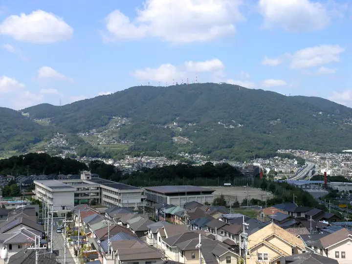
Mount Ikoma is a 642 m peak on the border between Higashiōsaka in Osaka Prefecture and Ikoma in Nara Prefecture, and is the highest of the Ikoma Range. Long a strategic divide between the Yamato and Naniwa regions, today its summit hosts the Ikoma-Sanjō Amusement Park and offers sweeping panoramic views of the Osaka plain — the night view is famously likened to a jewel box. The mountain lies within Kongō-Ikoma-Kisen Quasi-National Park (designated 1958) and appears on the Kansai Hyakumeizan and Kinki Hyakumeizan lists.
Mount Ikoma at a glance
- Weather: The most settled day in the next 7 days is Thu, November 5: cloudy, gusts up to 4 m/s.
- Route: The shortest is Crossing Ikoma from Ishikiri's Upper Shrine over the Summit to Ikoma Shoten: about 3 h 25 min, 8.4 km, about 620 m of climbing.
Mount Ikoma weather (hourly, 14 days)
Sunrise today 06:19, sunset 17:03
| Tue, 11/3 | Wed, 11/4 | Thu, 11/5 | Fri, 11/6 | Sat, 11/7 | Sun, 11/8 | Mon, 11/9 | Tue, 11/10 | Wed, 11/11 | Thu, 11/12 | Fri, 11/13 | Sat, 11/14 | Sun, 11/15 | Mon, 11/16 | Tue, 11/17 | |||||||||||||||||||||||||||||||||||||||||||||||||||||||||||||||||||||||
|---|---|---|---|---|---|---|---|---|---|---|---|---|---|---|---|---|---|---|---|---|---|---|---|---|---|---|---|---|---|---|---|---|---|---|---|---|---|---|---|---|---|---|---|---|---|---|---|---|---|---|---|---|---|---|---|---|---|---|---|---|---|---|---|---|---|---|---|---|---|---|---|---|---|---|---|---|---|---|---|---|---|---|---|---|---|
| Japan time | 21 | 23 | 1 | 3 | 5 | 7 | 9 | 11 | 13 | 15 | 17 | 19 | 21 | 0 | 3 | 6 | 9 | 12 | 15 | 18 | 21 | 0 | 3 | 6 | 9 | 12 | 15 | 18 | 21 | 0 | 3 | 6 | 9 | 12 | 15 | 18 | 21 | 0 | 3 | 6 | 9 | 12 | 15 | 18 | 21 | 0 | 3 | 6 | 9 | 12 | 15 | 21 | 3 | 9 | 15 | 21 | 3 | 9 | 15 | 21 | 3 | 9 | 15 | 21 | 3 | 9 | 15 | 21 | 3 | 9 | 15 | 21 | 3 | 9 | 15 | 21 | 3 | 9 | 15 | 21 | 3 | 9 | 15 | 21 | |
  | |  | |   |   |   | | | | |   | |   | |   |   | | |   | | | | |   | | |  | | | | | | | | | | | | | | | | | | | | | |  |   | | | | | | | | |   |  | | | | | | | | | | | | | |   | | | | | |  | | | | ||
| Temperature | °C | 11° | 10° | 8° | 7° | 7° | 8° | 11° | 13° | 15° | 16° | 14° | 13° | 14° | 13° | 13° | 12° | 13° | 16° | 17° | 15° | 14° | 14° | 14° | 12° | 15° | 16° | 17° | 13° | 10° | 9° | 8° | 7° | 10° | 11° | 11° | 8° | 6° | 5° | 5° | 5° | 8° | 11° | 11° | 8° | 8° | 7° | 6° | 7° | 8° | 12° | 12° | 9° | 6° | 9° | 14° | 9° | 6° | 8° | 10° | 6° | 3° | 7° | 11° | 6° | 4° | 9° | 11° | 6° | 3° | 6° | 13° | 7° | 5° | 10° | 15° | 11° | 11° | 13° | 15° | 9° | 5° | 7° | 12° | 6° |
| Precipitation | mm | 0.1 | 0.2 | 2.0 | 0.9 | 0.8 | 0.5 | 10 | 4.0 | 0.2 | 0.4 | 0.4 | 0.5 | 0.2 | 0.1 | 0.4 | 1.8 | 10 | 0.7 | ||||||||||||||||||||||||||||||||||||||||||||||||||||||||||||||||||
| New snow | cm | ||||||||||||||||||||||||||||||||||||||||||||||||||||||||||||||||||||||||||||||||||||
| Snow depth | cm | 0 | 0 | 0 | 0 | 0 | 0 | 0 | 0 | 0 | 0 | 0 | 0 | 0 | 0 | 0 | 0 | 0 | 0 | 0 | 0 | 0 | 0 | 0 | 0 | 0 | 0 | 0 | 0 | 0 | 0 | 0 | 0 | 0 | 0 | 0 | 0 | 0 | 0 | 0 | 0 | 0 | 0 | 0 | 0 | 0 | 0 | 0 | 0 | 0 | 0 | 0 | 0 | 0 | 0 | 0 | 0 | 0 | 0 | 0 | 0 | 0 | 0 | 0 | 0 | 0 | 0 | 0 | 0 | 0 | 0 | 0 | 0 | 0 | 0 | 0 | 0 | 0 | 0 | 0 | 0 | 0 | 0 | 0 | 0 |
| Wind | m/s | 2 | 0 | 1 | 1 | 1 | 1 | 0 | 1 | 2 | 3 | 3 | 3 | 4 | 4 | 2 | 1 | 1 | 1 | 1 | 0 | 1 | 2 | 3 | 1 | 4 | 3 | 4 | 3 | 2 | 3 | 2 | 1 | 3 | 4 | 4 | 3 | 1 | 1 | 1 | 0 | 1 | 3 | 2 | 2 | 1 | 0 | 0 | 1 | 0 | 1 | 1 | 0 | 0 | 1 | 4 | 2 | 3 | 2 | 5 | 1 | 1 | 1 | 2 | 2 | 1 | 0 | 4 | 1 | 1 | 1 | 1 | 1 | 1 | 1 | 1 | 1 | 1 | 1 | 5 | 3 | 1 | 1 | 1 | 0 |
| Wind gusts | m/s | 5 | 4 | 2 | 3 | 3 | 2 | 3 | 5 | 6 | 7 | 8 | 8 | 9 | 9 | 9 | 4 | 4 | 4 | 3 | 3 | 3 | 8 | 8 | 7 | 9 | 10 | 11 | 10 | 7 | 6 | 6 | 5 | 7 | 9 | 12 | 11 | 6 | 3 | 3 | 3 | 3 | 7 | 7 | 6 | 4 | 2 | 1 | 3 | 2 | 5 | 5 | 5 | 2 | 4 | 10 | 9 | 8 | 8 | 14 | 12 | 3 | 3 | 6 | 6 | 4 | 3 | 11 | 10 | 3 | 3 | 5 | 3 | 3 | 4 | 5 | 4 | 5 | 5 | 12 | 12 | 6 | 3 | 5 | 4 |
| Wind dir. | ↓ | ↓ | ↓ | ↓ | ↓ | ↓ | ↓ | ↓ | ↓ | ↓ | ↓ | ↓ | ↓ | ↓ | ↓ | ↓ | ↓ | ↓ | ↓ | ↓ | ↓ | ↓ | ↓ | ↓ | ↓ | ↓ | ↓ | ↓ | ↓ | ↓ | ↓ | ↓ | ↓ | ↓ | ↓ | ↓ | ↓ | ↓ | ↓ | ↓ | ↓ | ↓ | ↓ | ↓ | ↓ | ↓ | ↓ | ↓ | ↓ | ↓ | ↓ | ↓ | ↓ | ↓ | ↓ | ↓ | ↓ | ↓ | ↓ | ↓ | ↓ | ↓ | ↓ | ↓ | ↓ | ↓ | ↓ | ↓ | ↓ | ↓ | ↓ | ↓ | ↓ | ↓ | ↓ | ↓ | ↓ | ↓ | ↓ | ↓ | ↓ | ↓ | ↓ | ↓ | |
Mount Ikoma hiking routes
Hiking times are estimates calculated from the terrain.
Huts, campsites and lodging near Mount Ikoma
Campsites
- 風葉 キャンプ場
Lodging
- Okagero
- 緑風閣
- Kerinosu Gallery
- 三徳
- 城山旅館
Lists that include Mount Ikoma
Kansai 100 Famous Mountains · Kinki 100 Famous Mountains · Osaka 50 Mountains · Nara 100 Mountains to Explore · Elevations of 1003 Mountains of Japan
Mount Ikoma facts
- Also known as
- いこまさん
- Elevation
- 642 m
- Location
- Ikoma, Nara
34.678464, 135.678996 - National Park
- 金剛生駒紀泉国定公園
- Website
- www.city.higashiosaka.lg.jp
- Trail Map
- www.city.higashiosaka.lg.jp (PDF)
- Access Information
- osaka-info.jp
- Wikipedia
- ja.wikipedia.org