
Mount Aono
青ノ山
Utazu, Kagawa · Elevation 224 m
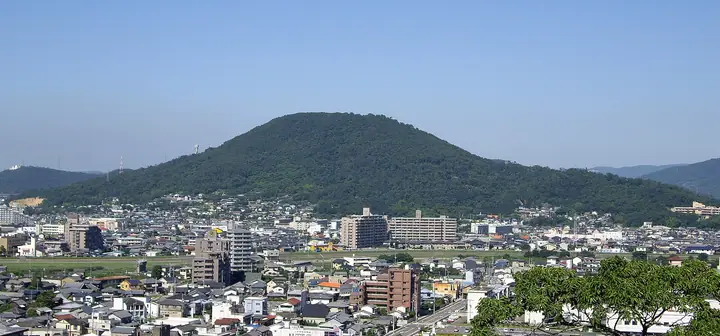
Mount Aono, also called Kawarakeyama, is a 224 m hill on the boundary of Utazu Town and Marugame, Kagawa Prefecture. Its summit lookout takes in the Great Seto Bridge, the islands of the Inland Sea and the town below, and the top has lawns, play equipment and walking paths and is known for cherry blossom. A road reaches close to the summit, making it a popular easy climb.
Mount Aono at a glance
- Weather: The most settled day in the next 7 days is Sun, November 8: clear, gusts up to 9 m/s.
Mount Aono weather (hourly, 14 days)
Sunrise today 06:26, sunset 17:11
| Tue, 11/3 | Wed, 11/4 | Thu, 11/5 | Fri, 11/6 | Sat, 11/7 | Sun, 11/8 | Mon, 11/9 | Tue, 11/10 | Wed, 11/11 | Thu, 11/12 | Fri, 11/13 | Sat, 11/14 | Sun, 11/15 | Mon, 11/16 | Tue, 11/17 | |||||||||||||||||||||||||||||||||||||||||||||||||||||||||||||||||||||||
|---|---|---|---|---|---|---|---|---|---|---|---|---|---|---|---|---|---|---|---|---|---|---|---|---|---|---|---|---|---|---|---|---|---|---|---|---|---|---|---|---|---|---|---|---|---|---|---|---|---|---|---|---|---|---|---|---|---|---|---|---|---|---|---|---|---|---|---|---|---|---|---|---|---|---|---|---|---|---|---|---|---|---|---|---|---|
| Japan time | 21 | 23 | 1 | 3 | 5 | 7 | 9 | 11 | 13 | 15 | 17 | 19 | 21 | 0 | 3 | 6 | 9 | 12 | 15 | 18 | 21 | 0 | 3 | 6 | 9 | 12 | 15 | 18 | 21 | 0 | 3 | 6 | 9 | 12 | 15 | 18 | 21 | 0 | 3 | 6 | 9 | 12 | 15 | 18 | 21 | 0 | 3 | 6 | 9 | 12 | 15 | 21 | 3 | 9 | 15 | 21 | 3 | 9 | 15 | 21 | 3 | 9 | 15 | 21 | 3 | 9 | 15 | 21 | 3 | 9 | 15 | 21 | 3 | 9 | 15 | 21 | 3 | 9 | 15 | 21 | 3 | 9 | 15 | 21 | |
  | |   | | |   |   | | | | |   | |   |   | | | |   | |   | |  | |  | | | | | | | | | | | | | | | | | | | | | | | | |   | | |   | | | | | | | |  | | | | | | | | | | | | | | | | | |   | |  | | | | ||
| Temperature | °C | 15° | 15° | 14° | 14° | 14° | 14° | 16° | 16° | 17° | 17° | 16° | 16° | 16° | 15° | 14° | 14° | 16° | 18° | 18° | 17° | 17° | 17° | 16° | 16° | 17° | 18° | 19° | 15° | 14° | 13° | 13° | 12° | 12° | 14° | 15° | 13° | 11° | 10° | 9° | 9° | 12° | 13° | 14° | 12° | 12° | 12° | 12° | 12° | 14° | 15° | 16° | 13° | 12° | 14° | 17° | 13° | 10° | 11° | 13° | 10° | 8° | 11° | 14° | 13° | 12° | 13° | 15° | 11° | 8° | 11° | 14° | 11° | 11° | 15° | 17° | 14° | 15° | 17° | 18° | 13° | 10° | 10° | 13° | 10° |
| Precipitation | mm | 0.2 | 0.8 | 0.4 | 0.4 | 0.3 | 0.7 | 0.1 | 3.7 | 0.1 | 0.1 | ||||||||||||||||||||||||||||||||||||||||||||||||||||||||||||||||||||||||||
| New snow | cm | ||||||||||||||||||||||||||||||||||||||||||||||||||||||||||||||||||||||||||||||||||||
| Snow depth | cm | 0 | 0 | 0 | 0 | 0 | 0 | 0 | 0 | 0 | 0 | 0 | 0 | 0 | 0 | 0 | 0 | 0 | 0 | 0 | 0 | 0 | 0 | 0 | 0 | 0 | 0 | 0 | 0 | 0 | 0 | 0 | 0 | 0 | 0 | 0 | 0 | 0 | 0 | 0 | 0 | 0 | 0 | 0 | 0 | 0 | 0 | 0 | 0 | 0 | 0 | 0 | 0 | 0 | 0 | 0 | 0 | 0 | 0 | 0 | 0 | 0 | 0 | 0 | 0 | 0 | 0 | 0 | 0 | 0 | 0 | 0 | 0 | 0 | 0 | 0 | 0 | 0 | 0 | 0 | 0 | 0 | 0 | 0 | 0 |
| Wind | m/s | 4 | 3 | 3 | 3 | 3 | 3 | 4 | 5 | 4 | 4 | 3 | 2 | 1 | 2 | 2 | 1 | 1 | 1 | 3 | 2 | 2 | 6 | 6 | 7 | 7 | 7 | 7 | 8 | 6 | 5 | 7 | 5 | 5 | 4 | 4 | 5 | 3 | 1 | 1 | 1 | 3 | 4 | 2 | 2 | 3 | 2 | 1 | 1 | 3 | 4 | 3 | 1 | 3 | 5 | 6 | 6 | 6 | 4 | 2 | 3 | 1 | 1 | 3 | 5 | 4 | 2 | 4 | 4 | 1 | 2 | 3 | 2 | 2 | 2 | 2 | 1 | 4 | 4 | 6 | 5 | 3 | 2 | 1 | 3 |
| Wind gusts | m/s | 8 | 7 | 6 | 6 | 6 | 5 | 8 | 10 | 10 | 9 | 8 | 5 | 4 | 5 | 4 | 3 | 4 | 4 | 6 | 6 | 4 | 9 | 13 | 13 | 15 | 14 | 14 | 15 | 15 | 12 | 12 | 12 | 11 | 10 | 10 | 9 | 9 | 6 | 2 | 3 | 7 | 9 | 8 | 5 | 5 | 5 | 4 | 3 | 6 | 8 | 8 | 8 | 6 | 10 | 13 | 14 | 11 | 11 | 9 | 7 | 5 | 3 | 8 | 9 | 9 | 7 | 9 | 10 | 7 | 4 | 7 | 7 | 4 | 4 | 5 | 4 | 7 | 10 | 11 | 12 | 10 | 5 | 5 | 6 |
| Wind dir. | ↓ | ↓ | ↓ | ↓ | ↓ | ↓ | ↓ | ↓ | ↓ | ↓ | ↓ | ↓ | ↓ | ↓ | ↓ | ↓ | ↓ | ↓ | ↓ | ↓ | ↓ | ↓ | ↓ | ↓ | ↓ | ↓ | ↓ | ↓ | ↓ | ↓ | ↓ | ↓ | ↓ | ↓ | ↓ | ↓ | ↓ | ↓ | ↓ | ↓ | ↓ | ↓ | ↓ | ↓ | ↓ | ↓ | ↓ | ↓ | ↓ | ↓ | ↓ | ↓ | ↓ | ↓ | ↓ | ↓ | ↓ | ↓ | ↓ | ↓ | ↓ | ↓ | ↓ | ↓ | ↓ | ↓ | ↓ | ↓ | ↓ | ↓ | ↓ | ↓ | ↓ | ↓ | ↓ | ↓ | ↓ | ↓ | ↓ | ↓ | ↓ | ↓ | ↓ | ↓ | |
Huts, campsites and lodging near Mount Aono
Lodging
- ホテルアネシス瀬戸大橋
- 善根宿うたんぐら
- ビジネスホテル青山
- HOTEL AZ
- 四国健康村
Mount Aono facts
- Also known as
- 土器山
- Elevation
- 224 m
- Location
- Utazu, Kagawa
34.300612, 133.822392 - Website
- sanpomichi.town.utazu.lg.jp
- Trail Map
- sanpomichi.town.utazu.lg.jp
- Wikipedia
- ja.wikipedia.org