
Mount Kiyama
城山
Sakaide, Kagawa · Elevation 462 m
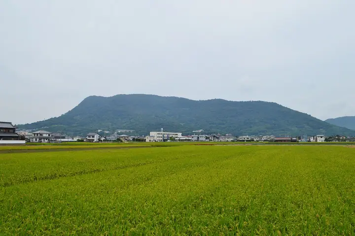
Mount Kiyama is a 462 m mountain in Sakaide, Kagawa Prefecture, the city's highest point. It holds the remains of an ancient mountain fortress designated a National Historic Site, with worked stones such as Kagami Stone, Tsubo Stone and Manaita Stone thought to be gate footings scattered across the slopes. The trekking route passes Fudo Falls and mountain streams, and the summit observation deck looks out over the city, the Shiwaku Islands in the Seto Inland Sea and the Asan mountains. From Kamogawa Station on the northeastern foot it is about 6 km, roughly 15 minutes by car or two hours on foot.
Mount Kiyama at a glance
- Weather: The most settled day in the next 7 days is Sun, November 8: clear, gusts up to 4 m/s.
Mount Kiyama weather (hourly, 14 days)
Sunrise today 06:25, sunset 17:11
| Tue, 11/3 | Wed, 11/4 | Thu, 11/5 | Fri, 11/6 | Sat, 11/7 | Sun, 11/8 | Mon, 11/9 | Tue, 11/10 | Wed, 11/11 | Thu, 11/12 | Fri, 11/13 | Sat, 11/14 | Sun, 11/15 | Mon, 11/16 | Tue, 11/17 | |||||||||||||||||||||||||||||||||||||||||||||||||||||||||||||||||||||
|---|---|---|---|---|---|---|---|---|---|---|---|---|---|---|---|---|---|---|---|---|---|---|---|---|---|---|---|---|---|---|---|---|---|---|---|---|---|---|---|---|---|---|---|---|---|---|---|---|---|---|---|---|---|---|---|---|---|---|---|---|---|---|---|---|---|---|---|---|---|---|---|---|---|---|---|---|---|---|---|---|---|---|---|
| Japan time | 21 | 23 | 1 | 3 | 5 | 7 | 9 | 11 | 13 | 15 | 17 | 19 | 21 | 0 | 3 | 6 | 9 | 12 | 15 | 18 | 21 | 0 | 3 | 6 | 9 | 12 | 15 | 18 | 21 | 0 | 3 | 6 | 9 | 12 | 15 | 18 | 21 | 0 | 3 | 6 | 9 | 12 | 15 | 18 | 21 | 0 | 3 | 6 | 9 | 15 | 21 | 3 | 9 | 15 | 21 | 3 | 9 | 15 | 21 | 3 | 9 | 15 | 21 | 3 | 9 | 15 | 21 | 3 | 9 | 15 | 21 | 3 | 9 | 15 | 21 | 3 | 9 | 15 | 21 | 3 | 9 | 15 | |
  | |   | | |   |   | | | | |   | |   |   | | | |   | | | |   |  |  | | | | | | | | | | | | | | | | | | | | | | | | | | |   | |   | | | |   | |  | | | | | | | | | | | | | | | | | | | |  | | | ||
| Temperature | °C | 12° | 11° | 11° | 11° | 11° | 11° | 14° | 15° | 15° | 15° | 13° | 13° | 13° | 12° | 11° | 11° | 14° | 18° | 18° | 16° | 15° | 15° | 14° | 13° | 15° | 17° | 17° | 13° | 11° | 10° | 10° | 8° | 10° | 12° | 13° | 9° | 8° | 7° | 5° | 4° | 10° | 12° | 12° | 9° | 10° | 10° | 9° | 9° | 12° | 15° | 10° | 8° | 12° | 14° | 10° | 7° | 9° | 11° | 7° | 4° | 9° | 12° | 9° | 8° | 11° | 13° | 7° | 4° | 10° | 13° | 8° | 7° | 13° | 15° | 12° | 13° | 15° | 17° | 10° | 7° | 8° | 11° |
| Precipitation | mm | 0.4 | 1.1 | 0.7 | 0.6 | 0.1 | 2.1 | 0.3 | 0.1 | 0.1 | 6 | 0.2 | 0.4 | ||||||||||||||||||||||||||||||||||||||||||||||||||||||||||||||||||||||
| New snow | cm | – | – | ||||||||||||||||||||||||||||||||||||||||||||||||||||||||||||||||||||||||||||||||
| Snow depth | cm | 0 | 0 | 0 | 0 | 0 | 0 | 0 | 0 | 0 | 0 | 0 | 0 | 0 | 0 | 0 | 0 | 0 | 0 | 0 | 0 | 0 | 0 | 0 | 0 | 0 | 0 | 0 | 0 | 0 | 0 | 0 | 0 | 0 | 0 | 0 | 0 | 0 | 0 | 0 | 0 | 0 | 0 | 0 | 0 | 0 | 0 | 0 | 0 | 0 | 0 | 0 | 0 | 0 | 0 | 0 | 0 | 0 | 0 | 0 | 0 | 0 | 0 | 0 | 0 | 0 | 0 | 0 | 0 | 0 | 0 | 0 | 0 | 0 | 0 | 0 | 0 | 0 | 0 | 0 | 0 | 0 | 0 |
| Wind | m/s | 2 | 2 | 2 | 2 | 2 | 3 | 4 | 5 | 4 | 3 | 2 | 2 | 1 | 2 | 2 | 1 | 1 | 1 | 2 | 2 | 2 | 3 | 4 | 3 | 5 | 6 | 5 | 6 | 5 | 5 | 6 | 4 | 5 | 4 | 3 | 2 | 2 | 0 | 1 | 2 | 0 | 1 | 1 | 1 | 1 | 1 | 0 | 1 | 2 | 2 | 1 | 2 | 4 | 5 | 4 | 4 | 3 | 2 | 2 | 2 | 1 | 2 | 2 | 2 | 1 | 4 | 2 | 1 | 2 | 3 | 2 | 2 | 2 | 2 | 2 | 4 | 4 | 4 | 4 | 2 | 1 | 1 |
| Wind gusts | m/s | 4 | 5 | 4 | 5 | 5 | 5 | 8 | 10 | 10 | 9 | 6 | 4 | 4 | 4 | 5 | 4 | 4 | 5 | 6 | 6 | 4 | 5 | 8 | 8 | 11 | 13 | 12 | 12 | 13 | 10 | 11 | 11 | 10 | 11 | 9 | 8 | 5 | 4 | 1 | 4 | 4 | 4 | 4 | 3 | 3 | 2 | 2 | 2 | 4 | 8 | 6 | 5 | 9 | 12 | 12 | 10 | 10 | 8 | 6 | 4 | 4 | 8 | 6 | 5 | 5 | 9 | 8 | 4 | 6 | 8 | 7 | 4 | 5 | 4 | 6 | 7 | 8 | 10 | 11 | 9 | 4 | 6 |
| Wind dir. | ↓ | ↓ | ↓ | ↓ | ↓ | ↓ | ↓ | ↓ | ↓ | ↓ | ↓ | ↓ | ↓ | ↓ | ↓ | ↓ | ↓ | ↓ | ↓ | ↓ | ↓ | ↓ | ↓ | ↓ | ↓ | ↓ | ↓ | ↓ | ↓ | ↓ | ↓ | ↓ | ↓ | ↓ | ↓ | ↓ | ↓ | ↓ | ↓ | ↓ | ↓ | ↓ | ↓ | ↓ | ↓ | ↓ | ↓ | ↓ | ↓ | ↓ | ↓ | ↓ | ↓ | ↓ | ↓ | ↓ | ↓ | ↓ | ↓ | ↓ | ↓ | ↓ | ↓ | ↓ | ↓ | ↓ | ↓ | ↓ | ↓ | ↓ | ↓ | ↓ | ↓ | ↓ | ↓ | ↓ | ↓ | ↓ | ↓ | ↓ | ↓ | ↓ | |
Huts, campsites and lodging near Mount Kiyama
Lodging
- ホテルニューセンチュリー坂出
Mount Kiyama facts
- Elevation
- 462 m
- Location
- Sakaide, Kagawa
34.289785, 133.889946 - Website
- www.city.sakaide.lg.jp