
Kugamiyama
国上山
Tsubame, Niigata · Elevation 313 m
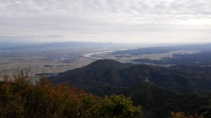
Kugamiyama is a 313-meter mountain in Tsubame City, Niigata, at the southern end of the Yahiko range and within Sado-Yahiko-Yoneyama Quasi-National Park. On its slopes stand the ancient temple Kokujo-ji and Gogo-an, the hermitage where the poet-monk Ryokan lived in the late Edo period, and its summit overlooks the Echigo Plain, the Sea of Japan, and Sado Island. It is also known for colonies of yukiwariso and katakuri wildflowers.
Kugamiyama at a glance
- Weather: The most settled day in the next 7 days is Wed, November 4: clear, gusts up to 9 m/s. Fri, Nov 6, Sat, Nov 7: strong wind (gusts up to 22 m/s).
Kugamiyama weather (hourly, 14 days)
Sunrise today 06:11, sunset 16:46
| Tue, 11/3 | Wed, 11/4 | Thu, 11/5 | Fri, 11/6 | Sat, 11/7 | Sun, 11/8 | Mon, 11/9 | Tue, 11/10 | Wed, 11/11 | Thu, 11/12 | Fri, 11/13 | Sat, 11/14 | Sun, 11/15 | Mon, 11/16 | Tue, 11/17 | |||||||||||||||||||||||||||||||||||||||||||||||||||||||||||||||||||||||
|---|---|---|---|---|---|---|---|---|---|---|---|---|---|---|---|---|---|---|---|---|---|---|---|---|---|---|---|---|---|---|---|---|---|---|---|---|---|---|---|---|---|---|---|---|---|---|---|---|---|---|---|---|---|---|---|---|---|---|---|---|---|---|---|---|---|---|---|---|---|---|---|---|---|---|---|---|---|---|---|---|---|---|---|---|---|
| Japan time | 15 | 17 | 19 | 21 | 23 | 1 | 3 | 5 | 7 | 9 | 11 | 13 | 15 | 18 | 21 | 0 | 3 | 6 | 9 | 12 | 15 | 18 | 21 | 0 | 3 | 6 | 9 | 12 | 15 | 18 | 21 | 0 | 3 | 6 | 9 | 12 | 15 | 18 | 21 | 0 | 3 | 6 | 9 | 12 | 15 | 18 | 21 | 0 | 3 | 6 | 9 | 15 | 21 | 3 | 9 | 15 | 21 | 3 | 9 | 15 | 21 | 3 | 9 | 15 | 21 | 3 | 9 | 15 | 21 | 3 | 9 | 15 | 21 | 3 | 9 | 15 | 21 | 3 | 9 | 15 | 21 | 3 | 9 | 15 | |
  |   | | | | | |   | | |  | | | | | |   | |   |   |   | | | | |   | | | | |   | | | | | | | | | | | | | |   | |   | | | | | | |   | | | | | |   | | | | | | | | | | | | |  | | | | | | | | | | | | ||
| Temperature | °C | 13° | 10° | 8° | 7° | 7° | 6° | 5° | 5° | 6° | 12° | 15° | 15° | 15° | 11° | 10° | 10° | 10° | 10° | 12° | 13° | 16° | 13° | 13° | 12° | 13° | 14° | 15° | 18° | 15° | 12° | 10° | 9° | 8° | 7° | 9° | 9° | 9° | 8° | 8° | 7° | 8° | 9° | 10° | 9° | 10° | 8° | 7° | 6° | 6° | 6° | 8° | 8° | 6° | 4° | 8° | 14° | 9° | 6° | 10° | 10° | 8° | 7° | 8° | 11° | 8° | 8° | 9° | 9° | 7° | 6° | 9° | 11° | 4° | 2° | 9° | 15° | 9° | 9° | 11° | 10° | 7° | 6° | 7° | 9° |
| Precipitation | mm | 3.1 | 9 | 4.1 | 1.5 | 1.0 | 1.4 | 0.6 | 2.9 | 3.0 | 0.9 | 1.1 | 1.8 | 0.7 | 2.7 | 3.3 | 1.2 | 0.7 | 0.8 | 1.0 | 0.5 | 0.3 | 0.4 | 0.4 | 0.2 | 0.4 | 0.8 | 1.1 | 1.2 | 0.7 | 6 | 15 | 2.8 | 1.3 | 0.8 | 0.3 | 1.3 | 0.5 | 0.2 | 4.5 | 2.1 | 3.2 | 1.8 | 9 | 6 | 0.2 | |||||||||||||||||||||||||||||||||||||||
| New snow | cm | ||||||||||||||||||||||||||||||||||||||||||||||||||||||||||||||||||||||||||||||||||||
| Snow depth | cm | 0 | 0 | 0 | 0 | 0 | 0 | 0 | 0 | 0 | 0 | 0 | 0 | 0 | 0 | 0 | 0 | 0 | 0 | 0 | 0 | 0 | 0 | 0 | 0 | 0 | 0 | 0 | 0 | 0 | 0 | 0 | 0 | 0 | 0 | 0 | 0 | 0 | 0 | 0 | 0 | 0 | 0 | 0 | 0 | 0 | 0 | 0 | 0 | 0 | 0 | 0 | 0 | 0 | 0 | 0 | 0 | 0 | 0 | 0 | 0 | 0 | 0 | 0 | 0 | 0 | 0 | 0 | 0 | 0 | 0 | 0 | 0 | 0 | 0 | 0 | 0 | 0 | 0 | 0 | 0 | 0 | 0 | 0 | 0 |
| Wind | m/s | 2 | 1 | 2 | 2 | 1 | 2 | 1 | 2 | 2 | 2 | 2 | 4 | 4 | 4 | 2 | 2 | 1 | 2 | 0 | 1 | 1 | 1 | 1 | 2 | 2 | 4 | 6 | 8 | 8 | 6 | 5 | 4 | 5 | 7 | 9 | 10 | 9 | 8 | 7 | 7 | 6 | 5 | 5 | 5 | 4 | 1 | 1 | 2 | 2 | 2 | 3 | 5 | 2 | 2 | 4 | 3 | 6 | 7 | 6 | 6 | 2 | 1 | 2 | 4 | 4 | 2 | 6 | 4 | 1 | 2 | 2 | 2 | 1 | 0 | 1 | 0 | 3 | 1 | 0 | 8 | 5 | 0 | 2 | 2 |
| Wind gusts | m/s | 8 | 6 | 4 | 4 | 3 | 3 | 3 | 3 | 3 | 4 | 6 | 8 | 9 | 9 | 8 | 4 | 6 | 4 | 3 | 4 | 4 | 3 | 2 | 3 | 4 | 8 | 11 | 16 | 18 | 17 | 14 | 10 | 12 | 14 | 18 | 22 | 22 | 19 | 16 | 14 | 13 | 11 | 12 | 12 | 10 | 8 | 3 | 3 | 4 | 4 | 6 | 11 | 10 | 3 | 8 | 9 | 15 | 16 | 17 | 17 | 14 | 6 | 5 | 10 | 9 | 9 | 13 | 13 | 8 | 5 | 6 | 6 | 5 | 2 | 4 | 5 | 5 | 5 | 6 | 15 | 15 | 10 | 5 | 6 |
| Wind dir. | ↓ | ↓ | ↓ | ↓ | ↓ | ↓ | ↓ | ↓ | ↓ | ↓ | ↓ | ↓ | ↓ | ↓ | ↓ | ↓ | ↓ | ↓ | ↓ | ↓ | ↓ | ↓ | ↓ | ↓ | ↓ | ↓ | ↓ | ↓ | ↓ | ↓ | ↓ | ↓ | ↓ | ↓ | ↓ | ↓ | ↓ | ↓ | ↓ | ↓ | ↓ | ↓ | ↓ | ↓ | ↓ | ↓ | ↓ | ↓ | ↓ | ↓ | ↓ | ↓ | ↓ | ↓ | ↓ | ↓ | ↓ | ↓ | ↓ | ↓ | ↓ | ↓ | ↓ | ↓ | ↓ | ↓ | ↓ | ↓ | ↓ | ↓ | ↓ | ↓ | ↓ | ↓ | ↓ | ↓ | ↓ | ↓ | ↓ | ↓ | ↓ | ↓ | ↓ | ↓ | |
Huts, campsites and lodging near Kugamiyama
Lodging
- 割烹の宿 山長
- 太古の湯
- 夕華
- 民宿 いしい
Kugamiyama facts
- Elevation
- 313 m
- Location
- Tsubame, Niigata
37.670412, 138.815603 - National Park
- 佐渡弥彦米山国定公園
- Website
- tsubame-kankou.jp
- Trail Map
- www.city.tsubame.niigata.jp
- Wikipedia
- ja.wikipedia.org