
Jōyama
城山
Munakata, Fukuoka · Elevation 369 m
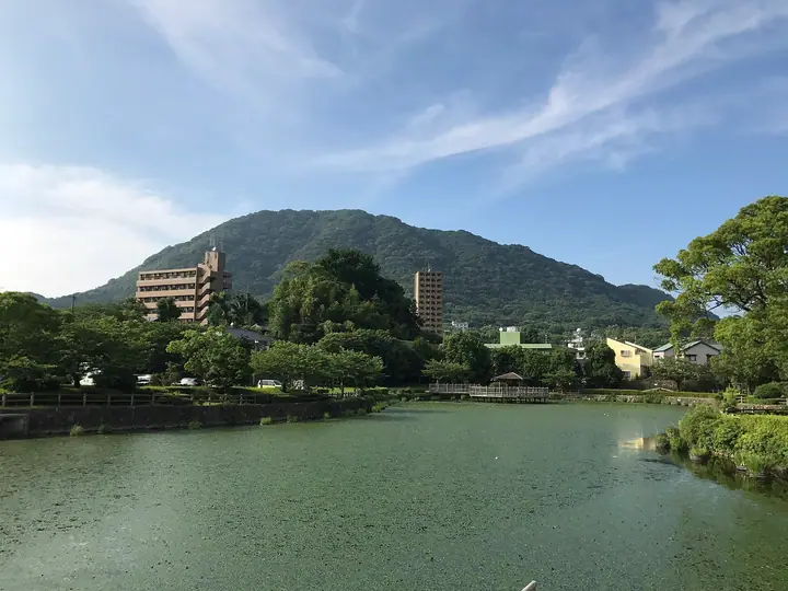
A 369.2-meter peak at Ryōgon-ji in Munakata City, Fukuoka Prefecture, easternmost of the "Four Mounds of Munakata" range together with Yugawa-yama, Kōdaiji-yama and Kanayama. Also known as Akamayama and Tsutaga-take, the summit carries the remains of Tsutaga-take Castle (the Akama Kojō ruins), the main fortress of the Munakata Daiguji during the Sengoku period. From the Akama trailhead a flight of wooden steps and steep grade leads to the top, opening onto a view across the Genkai Sea toward the sacred island of Okinoshima. Logbook entries on the summit run to more than 3,000 a month, making this one of the most-climbed satoyama in the region. Listed in the Fukuoka Ultra-Low Mountains and the Munakata Four Mounds.
Jōyama at a glance
- Weather: The most settled day in the next 7 days is Sun, November 8: clear, gusts up to 8 m/s.
Jōyama weather (hourly, 14 days)
Sunrise today 06:38, sunset 17:25
| Tue, 11/3 | Wed, 11/4 | Thu, 11/5 | Fri, 11/6 | Sat, 11/7 | Sun, 11/8 | Mon, 11/9 | Tue, 11/10 | Wed, 11/11 | Thu, 11/12 | Fri, 11/13 | Sat, 11/14 | Sun, 11/15 | Mon, 11/16 | Tue, 11/17 | |||||||||||||||||||||||||||||||||||||||||||||||||||||||||||||||||||||||
|---|---|---|---|---|---|---|---|---|---|---|---|---|---|---|---|---|---|---|---|---|---|---|---|---|---|---|---|---|---|---|---|---|---|---|---|---|---|---|---|---|---|---|---|---|---|---|---|---|---|---|---|---|---|---|---|---|---|---|---|---|---|---|---|---|---|---|---|---|---|---|---|---|---|---|---|---|---|---|---|---|---|---|---|---|---|
| Japan time | 15 | 17 | 19 | 21 | 23 | 1 | 3 | 5 | 7 | 9 | 11 | 13 | 15 | 18 | 21 | 0 | 3 | 6 | 9 | 12 | 15 | 18 | 21 | 0 | 3 | 6 | 9 | 12 | 15 | 18 | 21 | 0 | 3 | 6 | 9 | 12 | 15 | 18 | 21 | 0 | 3 | 6 | 9 | 12 | 15 | 18 | 21 | 0 | 3 | 6 | 9 | 15 | 21 | 3 | 9 | 15 | 21 | 3 | 9 | 15 | 21 | 3 | 9 | 15 | 21 | 3 | 9 | 15 | 21 | 3 | 9 | 15 | 21 | 3 | 9 | 15 | 21 | 3 | 9 | 15 | 21 | 3 | 9 | 15 | |
  | |   | |   | | | |   | | | |   | |   | | | | |   |   | |   | |  | | |  | | | | | | | | | | | | | | | | | | | | | | | |   | |   | | | | | | | | | | |   | | | | | | | | | | | | | | | | | | | | ||
| Temperature | °C | 16° | 16° | 15° | 15° | 15° | 15° | 14° | 13° | 12° | 14° | 15° | 17° | 17° | 15° | 15° | 14° | 14° | 14° | 17° | 17° | 19° | 18° | 17° | 17° | 16° | 16° | 16° | 15° | 14° | 13° | 12° | 10° | 10° | 9° | 10° | 11° | 11° | 10° | 9° | 8° | 8° | 8° | 11° | 13° | 14° | 12° | 12° | 12° | 12° | 12° | 14° | 14° | 11° | 11° | 12° | 13° | 13° | 10° | 11° | 12° | 9° | 7° | 11° | 13° | 12° | 10° | 14° | 15° | 11° | 10° | 12° | 17° | 13° | 12° | 13° | 14° | 16° | 15° | 16° | 15° | 13° | 12° | 12° | 14° |
| Precipitation | mm | 0.2 | 3.4 | 3.1 | 0.2 | 0.6 | 0.4 | 0.4 | 0.2 | 0.3 | 1.5 | 1.2 | 1.3 | 0.5 | 0.2 | 0.2 | 0.2 | 6 | 18 | 4.8 | 0.4 | 0.4 | 0.2 | 1.0 | |||||||||||||||||||||||||||||||||||||||||||||||||||||||||||||
| New snow | cm | ||||||||||||||||||||||||||||||||||||||||||||||||||||||||||||||||||||||||||||||||||||
| Snow depth | cm | 0 | 0 | 0 | 0 | 0 | 0 | 0 | 0 | 0 | 0 | 0 | 0 | 0 | 0 | 0 | 0 | 0 | 0 | 0 | 0 | 0 | 0 | 0 | 0 | 0 | 0 | 0 | 0 | 0 | 0 | 0 | 0 | 0 | 0 | 0 | 0 | 0 | 0 | 0 | 0 | 0 | 0 | 0 | 0 | 0 | 0 | 0 | 0 | 0 | 0 | 0 | 0 | 0 | 0 | 0 | 0 | 0 | 0 | 0 | 0 | 0 | 0 | 0 | 0 | 0 | 0 | 0 | 0 | 0 | 0 | 0 | 0 | 0 | 0 | 0 | 0 | 0 | 0 | 0 | 0 | 0 | 0 | 0 | 0 |
| Wind | m/s | 5 | 4 | 4 | 5 | 4 | 4 | 4 | 5 | 4 | 4 | 4 | 4 | 4 | 4 | 4 | 2 | 3 | 2 | 4 | 4 | 5 | 6 | 5 | 6 | 6 | 6 | 7 | 7 | 7 | 8 | 8 | 8 | 8 | 7 | 6 | 5 | 3 | 2 | 2 | 2 | 3 | 3 | 3 | 3 | 4 | 2 | 2 | 1 | 1 | 4 | 4 | 4 | 3 | 3 | 4 | 6 | 6 | 7 | 5 | 4 | 1 | 3 | 3 | 3 | 2 | 2 | 3 | 5 | 4 | 4 | 4 | 0 | 4 | 3 | 3 | 4 | 4 | 5 | 5 | 6 | 8 | 5 | 4 | 4 |
| Wind gusts | m/s | 11 | 10 | 8 | 8 | 8 | 8 | 8 | 8 | 8 | 8 | 9 | 9 | 8 | 7 | 9 | 7 | 5 | 6 | 8 | 9 | 11 | 11 | 14 | 11 | 11 | 11 | 14 | 14 | 15 | 14 | 15 | 15 | 15 | 14 | 13 | 13 | 10 | 7 | 4 | 4 | 6 | 7 | 6 | 6 | 8 | 7 | 4 | 3 | 4 | 6 | 8 | 11 | 8 | 6 | 9 | 12 | 13 | 14 | 13 | 11 | 8 | 6 | 7 | 8 | 7 | 6 | 6 | 10 | 10 | 8 | 8 | 9 | 8 | 7 | 8 | 8 | 9 | 10 | 11 | 13 | 15 | 15 | 8 | 9 |
| Wind dir. | ↓ | ↓ | ↓ | ↓ | ↓ | ↓ | ↓ | ↓ | ↓ | ↓ | ↓ | ↓ | ↓ | ↓ | ↓ | ↓ | ↓ | ↓ | ↓ | ↓ | ↓ | ↓ | ↓ | ↓ | ↓ | ↓ | ↓ | ↓ | ↓ | ↓ | ↓ | ↓ | ↓ | ↓ | ↓ | ↓ | ↓ | ↓ | ↓ | ↓ | ↓ | ↓ | ↓ | ↓ | ↓ | ↓ | ↓ | ↓ | ↓ | ↓ | ↓ | ↓ | ↓ | ↓ | ↓ | ↓ | ↓ | ↓ | ↓ | ↓ | ↓ | ↓ | ↓ | ↓ | ↓ | ↓ | ↓ | ↓ | ↓ | ↓ | ↓ | ↓ | ↓ | ↓ | ↓ | ↓ | ↓ | ↓ | ↓ | ↓ | ↓ | ↓ | ↓ | ↓ | |
Jōyama facts
- Also known as
- 赤馬山 · 蔦ヶ嶽
- Elevation
- 369 m
- Location
- Munakata, Fukuoka
33.818652, 130.590684 - Website
- www.city.munakata.lg.jp
- Trail Map
- www.city.munakata.lg.jp (PDF)