
Ushioku-no-Gangaharasuri-yama
牛奥ノ雁ヶ腹摺山
Koshu, Yamanashi / Ōtsuki-shi, Yamanashi · Elevation 1,990 m
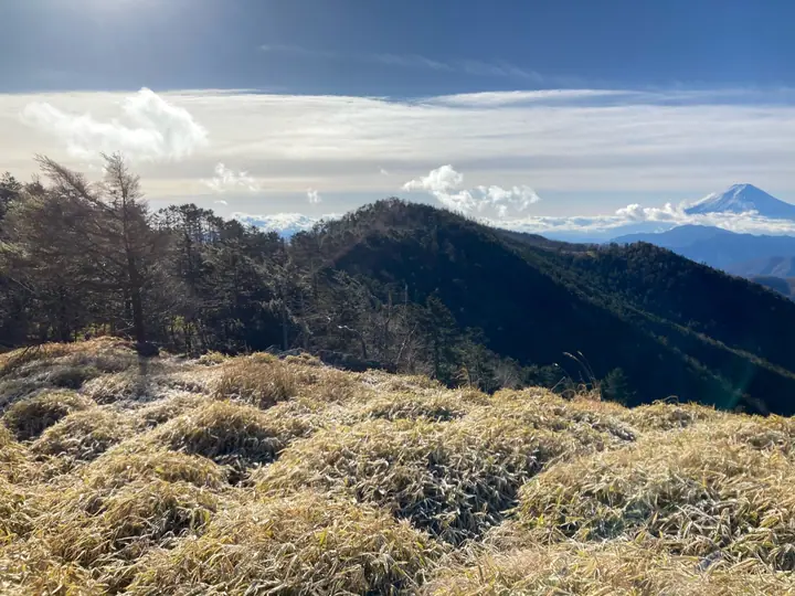
Ushioku-no-Gangaharasuri-yama (1,990 m) lies on the border between Ōtsuki City and Kōshū City in Yamanashi Prefecture, at the southern end of the Daibosatsu Range. With nine hiragana characters in its name, it is reputedly the longest mountain name in Japan. Designated the Second Summit of Ōtsuki's 'Twelve Splendid Views of Fuji' in 1992, its open ridge crown offers a sweeping panorama of Mount Fuji together with the Southern Alps and Oku-Chichibu peaks, complementing neighbouring Mount Koganesawa to the north.
Ushioku-no-Gangaharasuri-yama at a glance
- Weather: The most settled day in the next 7 days is Sun, November 8: clear, gusts up to 8 m/s.
Ushioku-no-Gangaharasuri-yama weather (hourly, 14 days)
Sunrise today 06:08, sunset 16:49
| Tue, 11/3 | Wed, 11/4 | Thu, 11/5 | Fri, 11/6 | Sat, 11/7 | Sun, 11/8 | Mon, 11/9 | Tue, 11/10 | Wed, 11/11 | Thu, 11/12 | Fri, 11/13 | Sat, 11/14 | Sun, 11/15 | Mon, 11/16 | Tue, 11/17 | |||||||||||||||||||||||||||||||||||||||||||||||||||||||||||||||||||||||
|---|---|---|---|---|---|---|---|---|---|---|---|---|---|---|---|---|---|---|---|---|---|---|---|---|---|---|---|---|---|---|---|---|---|---|---|---|---|---|---|---|---|---|---|---|---|---|---|---|---|---|---|---|---|---|---|---|---|---|---|---|---|---|---|---|---|---|---|---|---|---|---|---|---|---|---|---|---|---|---|---|---|---|---|---|---|
| Japan time | 15 | 17 | 19 | 21 | 23 | 1 | 3 | 5 | 7 | 9 | 11 | 13 | 15 | 18 | 21 | 0 | 3 | 6 | 9 | 12 | 15 | 18 | 21 | 0 | 3 | 6 | 9 | 12 | 15 | 18 | 21 | 0 | 3 | 6 | 9 | 12 | 15 | 18 | 21 | 0 | 3 | 6 | 9 | 12 | 15 | 18 | 21 | 0 | 3 | 6 | 9 | 15 | 21 | 3 | 9 | 15 | 21 | 3 | 9 | 15 | 21 | 3 | 9 | 15 | 21 | 3 | 9 | 15 | 21 | 3 | 9 | 15 | 21 | 3 | 9 | 15 | 21 | 3 | 9 | 15 | 21 | 3 | 9 | 15 | |
  |   | | | | |   | |   | | | |   | | | | | | |   | | |   |  | | |  | | | |   | | | | | | | | | | | |   | | | | |   | | | | | |   | | | | | | |   |  | | | | | | | | | | | | | | | |   | | | | | | | ||
| Temperature | °C | 6° | 4° | 4° | 3° | 3° | 3° | 3° | 2° | 2° | 3° | 6° | 5° | 4° | 3° | 3° | 3° | 3° | 4° | 7° | 12° | 9° | 6° | 5° | 4° | 5° | 5° | 10° | 14° | 13° | 6° | 3° | 2° | 0° | -2° | 4° | 7° | 7° | 0° | -1° | 0° | 0° | -1° | 5° | 8° | 6° | 1° | 2° | 1° | 1° | 1° | 3° | 4° | 0° | -1° | 0° | 3° | 0° | -3° | 1° | 3° | -5° | -4° | 2° | 5° | 0° | -3° | 5° | 7° | -2° | -2° | 3° | 4° | -1° | -2° | 4° | 6° | 4° | 4° | 10° | 13° | 0° | 2° | 1° | 2° |
| Precipitation | mm | 0.4 | 0.5 | 1.1 | 1.4 | 2.3 | 0.7 | 0.2 | 1.4 | 0.3 | 7 | 13 | 12 | 1.6 | 1.3 | 0.5 | 0.2 | 1.9 | 1.1 | 0.1 | 0.1 | 8 | 19 | ||||||||||||||||||||||||||||||||||||||||||||||||||||||||||||||
| New snow | cm | <.1 | <.1 | ||||||||||||||||||||||||||||||||||||||||||||||||||||||||||||||||||||||||||||||||||
| Snow depth | cm | 0 | 0 | 0 | 0 | 0 | 0 | 0 | 0 | 0 | 0 | 0 | 0 | 0 | 0 | 0 | 0 | 0 | 0 | 0 | 0 | 0 | 0 | 0 | 0 | 0 | 0 | 0 | 0 | 0 | 0 | 0 | 0 | 0 | 0 | 0 | 0 | 0 | 0 | 0 | 0 | 0 | 0 | 0 | 0 | 0 | 0 | 0 | 0 | 0 | 0 | 0 | 0 | 0 | <1 | <1 | 0 | 0 | 0 | 0 | 0 | 0 | 0 | 0 | 0 | 0 | 0 | 0 | 0 | 0 | 0 | 0 | 0 | 0 | 0 | 0 | 0 | 0 | 0 | 0 | 0 | 0 | 0 | 0 | 0 |
| Wind | m/s | 1 | 1 | 1 | 1 | 1 | 1 | 1 | 1 | 1 | 1 | 1 | 2 | 1 | 1 | 2 | 2 | 2 | 3 | 2 | 1 | 2 | 0 | 0 | 1 | 1 | 0 | 1 | 2 | 2 | 1 | 1 | 0 | 0 | 0 | 1 | 4 | 1 | 0 | 1 | 1 | 0 | 0 | 1 | 2 | 2 | 1 | 1 | 0 | 0 | 0 | 1 | 1 | 2 | 1 | 0 | 2 | 1 | 1 | 3 | 2 | 0 | 1 | 2 | 3 | 1 | 0 | 1 | 1 | 0 | 0 | 1 | 2 | 1 | 1 | 2 | 2 | 1 | 2 | 1 | 1 | 2 | 1 | 1 | 2 |
| Wind gusts | m/s | 4 | 3 | 2 | 3 | 3 | 3 | 3 | 4 | 4 | 4 | 5 | 6 | 6 | 5 | 6 | 7 | 9 | 9 | 9 | 6 | 7 | 7 | 4 | 5 | 5 | 5 | 6 | 8 | 9 | 6 | 4 | 4 | 5 | 6 | 9 | 13 | 14 | 8 | 5 | 5 | 5 | 4 | 5 | 8 | 8 | 6 | 5 | 5 | 5 | 5 | 5 | 7 | 5 | 5 | 4 | 8 | 7 | 7 | 14 | 15 | 10 | 4 | 7 | 10 | 9 | 4 | 5 | 7 | 5 | 3 | 5 | 8 | 7 | 5 | 8 | 11 | 9 | 11 | 10 | 9 | 13 | 6 | 5 | 8 |
| Wind dir. | ↓ | ↓ | ↓ | ↓ | ↓ | ↓ | ↓ | ↓ | ↓ | ↓ | ↓ | ↓ | ↓ | ↓ | ↓ | ↓ | ↓ | ↓ | ↓ | ↓ | ↓ | ↓ | ↓ | ↓ | ↓ | ↓ | ↓ | ↓ | ↓ | ↓ | ↓ | ↓ | ↓ | ↓ | ↓ | ↓ | ↓ | ↓ | ↓ | ↓ | ↓ | ↓ | ↓ | ↓ | ↓ | ↓ | ↓ | ↓ | ↓ | ↓ | ↓ | ↓ | ↓ | ↓ | ↓ | ↓ | ↓ | ↓ | ↓ | ↓ | ↓ | ↓ | ↓ | ↓ | ↓ | ↓ | ↓ | ↓ | ↓ | ↓ | ↓ | ↓ | ↓ | ↓ | ↓ | ↓ | ↓ | ↓ | ↓ | ↓ | ↓ | ↓ | ↓ | ↓ | |
Huts, campsites and lodging near Ushioku-no-Gangaharasuri-yama
Mountain huts
- 湯ノ沢峠避難小屋
- Kaizanso 2025: open all year · reservation required · sleeps 26
- Lodge Chobei 2026: open all year · reservation required · sleeps 23
- 勝縁荘
- Fukuchanso reservation required · sleeps 50
Campsites
- 大菩薩 キャンプ
- 福ちゃん荘キャンプ場
Lodging
- Sagashiokan
Lists that include Ushioku-no-Gangaharasuri-yama
12 Beautiful Views of Mount Fuji in Otsuki City (Yamanashi Prefecture)
Ushioku-no-Gangaharasuri-yama facts
- Also known as
- ガンノハラスリ・オッタテ
- Elevation
- 1,990 m
- Location
- Koshu, Yamanashi / Ōtsuki-shi, Yamanashi
35.705937, 138.856673 - Website
- www.city.otsuki.yamanashi.jp
- Trail Map
- www.city.otsuki.yamanashi.jp (PDF)
- Wikipedia
- ja.wikipedia.org
Mountains near Ushioku-no-Gangaharasuri-yama
- Mt. Kumazawayama 1,978 m
- Mt. Oyashirazunoatama 1,951 m
- Myokennoatama 1,980 m
- Mount Daibosatsu 2,056.9 m
- Mount Tengudana 1,957 m
- Mt. Koganezawa 2,014 m
- Mount Tenjin 589 m
- Mount Takigoyama 1,615 m
- Mt. Kurodake 1,987.5 m
- Mt. Shirayanomaru 1,920 m
- Kawakurumisawanoatama 1,940 m
- Mt. Okura-Takamaru 1,781 m