
Mt. Toyoukeyama
豊受山
Shikokuchūō-shi, Ehime · Elevation 1,247 m
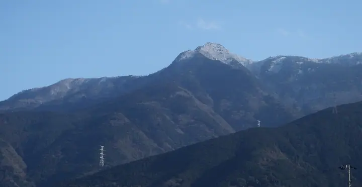
Mt. Toyoukeyama is a 1,247 m peak in the eastern Hōō Range in Shikokuchūō City, Ehime Prefecture. Rising east of Mount Akaboshi, it is crowned by Toyouke Shrine, dedicated to the deity Toyoukehime-no-Mikoto; a nearby "wind hole" is held to be the source of the fierce local Yamaji wind, and the shrine holds an annual wind-calming rite. Known affectionately as "Otoiko-san," it is noted for its rhododendron and dogtooth-violet colonies and is one of the 100 Famous Mountains of Shikoku.
Mt. Toyoukeyama at a glance
- Weather: The most settled day in the next 7 days is Sun, November 8: clear, gusts up to 7 m/s.
- Route: The shortest is Mount Akaboshi and Mount Toyouke from Noda Trailhead: about 7 h 10 min, 10.1 km, about 1,280 m of climbing.
Mt. Toyoukeyama weather (hourly, 14 days)
Sunrise today 06:27, sunset 17:13
| Tue, 11/3 | Wed, 11/4 | Thu, 11/5 | Fri, 11/6 | Sat, 11/7 | Sun, 11/8 | Mon, 11/9 | Tue, 11/10 | Wed, 11/11 | Thu, 11/12 | Fri, 11/13 | Sat, 11/14 | Sun, 11/15 | Mon, 11/16 | Tue, 11/17 | |||||||||||||||||||||||||||||||||||||||||||||||||||||||||||||||||||||||
|---|---|---|---|---|---|---|---|---|---|---|---|---|---|---|---|---|---|---|---|---|---|---|---|---|---|---|---|---|---|---|---|---|---|---|---|---|---|---|---|---|---|---|---|---|---|---|---|---|---|---|---|---|---|---|---|---|---|---|---|---|---|---|---|---|---|---|---|---|---|---|---|---|---|---|---|---|---|---|---|---|---|---|---|---|---|
| Japan time | 21 | 23 | 1 | 3 | 5 | 7 | 9 | 11 | 13 | 15 | 17 | 19 | 21 | 0 | 3 | 6 | 9 | 12 | 15 | 18 | 21 | 0 | 3 | 6 | 9 | 12 | 15 | 18 | 21 | 0 | 3 | 6 | 9 | 12 | 15 | 18 | 21 | 0 | 3 | 6 | 9 | 12 | 15 | 18 | 21 | 0 | 3 | 6 | 9 | 12 | 15 | 21 | 3 | 9 | 15 | 21 | 3 | 9 | 15 | 21 | 3 | 9 | 15 | 21 | 3 | 9 | 15 | 21 | 3 | 9 | 15 | 21 | 3 | 9 | 15 | 21 | 3 | 9 | 15 | 21 | 3 | 9 | 15 | 21 | |
  | | |   |   |   |   | | | | | | |   | | |   |   | | | | |   |   | | |  |  | | | | | | | | | | | | | | | | | | | | | | |   | | | | | | | | | | | | | | |   | |  | | | | | | | | | | | | | | | |  | ||
| Temperature | °C | 7° | 6° | 6° | 6° | 6° | 6° | 8° | 9° | 10° | 10° | 9° | 8° | 8° | 8° | 8° | 8° | 10° | 12° | 12° | 11° | 10° | 10° | 9° | 8° | 9° | 11° | 11° | 8° | 6° | 5° | 5° | 4° | 4° | 6° | 6° | 5° | 3° | 2° | 2° | 2° | 5° | 7° | 6° | 4° | 4° | 5° | 5° | 5° | 7° | 8° | 7° | 4° | 2° | 6° | 8° | 5° | 2° | 3° | 5° | 4° | 3° | 4° | 6° | 5° | 3° | 5° | 7° | 2° | 0° | 5° | 8° | 4° | 4° | 9° | 11° | 8° | 9° | 9° | 11° | 5° | 2° | 3° | 5° | 2° |
| Precipitation | mm | 0.2 | 1.7 | 1.6 | 0.2 | 1.2 | 1.3 | 1.7 | 1.9 | 1.1 | 0.6 | 0.3 | 0.1 | 0.9 | 0.2 | 0.8 | 0.9 | 0.2 | 0.3 | 0.2 | 0.6 | 1.1 | 0.5 | 3.4 | 0.1 | 1.3 | 1.3 | 3.0 | 0.2 | ||||||||||||||||||||||||||||||||||||||||||||||||||||||||
| New snow | cm | ||||||||||||||||||||||||||||||||||||||||||||||||||||||||||||||||||||||||||||||||||||
| Snow depth | cm | 0 | 0 | 0 | 0 | 0 | 0 | 0 | 0 | 0 | 0 | 0 | 0 | 0 | 0 | 0 | 0 | 0 | 0 | 0 | 0 | 0 | 0 | 0 | 0 | 0 | 0 | 0 | 0 | 0 | 0 | 0 | 0 | 0 | 0 | 0 | 0 | 0 | 0 | 0 | 0 | 0 | 0 | 0 | 0 | 0 | 0 | 0 | 0 | 0 | 0 | 0 | 0 | 0 | 0 | 0 | 0 | 0 | 0 | 0 | 0 | 0 | 0 | 0 | 0 | 0 | 0 | 0 | 0 | 0 | 0 | 0 | 0 | 0 | 0 | 0 | 0 | 0 | 0 | 0 | 0 | 0 | 0 | 0 | 0 |
| Wind | m/s | 2 | 1 | 1 | 1 | 2 | 1 | 2 | 2 | 2 | 2 | 1 | 1 | 0 | 2 | 1 | 1 | 1 | 2 | 1 | 1 | 1 | 3 | 4 | 4 | 5 | 6 | 6 | 6 | 5 | 5 | 5 | 5 | 5 | 4 | 3 | 3 | 2 | 1 | 1 | 2 | 3 | 3 | 3 | 2 | 1 | 1 | 1 | 1 | 1 | 3 | 1 | 1 | 3 | 3 | 4 | 5 | 5 | 3 | 1 | 2 | 1 | 2 | 1 | 2 | 2 | 2 | 3 | 2 | 1 | 1 | 2 | 2 | 2 | 1 | 1 | 1 | 2 | 4 | 3 | 4 | 2 | 2 | 2 | 1 |
| Wind gusts | m/s | 5 | 5 | 3 | 4 | 4 | 5 | 5 | 7 | 5 | 5 | 4 | 3 | 3 | 4 | 4 | 3 | 4 | 5 | 5 | 6 | 7 | 8 | 14 | 11 | 13 | 13 | 14 | 14 | 14 | 13 | 13 | 12 | 13 | 13 | 11 | 9 | 8 | 6 | 4 | 5 | 7 | 7 | 7 | 7 | 5 | 4 | 4 | 5 | 5 | 7 | 7 | 7 | 6 | 7 | 11 | 12 | 13 | 12 | 9 | 6 | 4 | 5 | 6 | 5 | 7 | 7 | 9 | 9 | 6 | 5 | 6 | 5 | 6 | 7 | 9 | 8 | 6 | 10 | 10 | 11 | 9 | 5 | 6 | 5 |
| Wind dir. | ↓ | ↓ | ↓ | ↓ | ↓ | ↓ | ↓ | ↓ | ↓ | ↓ | ↓ | ↓ | ↓ | ↓ | ↓ | ↓ | ↓ | ↓ | ↓ | ↓ | ↓ | ↓ | ↓ | ↓ | ↓ | ↓ | ↓ | ↓ | ↓ | ↓ | ↓ | ↓ | ↓ | ↓ | ↓ | ↓ | ↓ | ↓ | ↓ | ↓ | ↓ | ↓ | ↓ | ↓ | ↓ | ↓ | ↓ | ↓ | ↓ | ↓ | ↓ | ↓ | ↓ | ↓ | ↓ | ↓ | ↓ | ↓ | ↓ | ↓ | ↓ | ↓ | ↓ | ↓ | ↓ | ↓ | ↓ | ↓ | ↓ | ↓ | ↓ | ↓ | ↓ | ↓ | ↓ | ↓ | ↓ | ↓ | ↓ | ↓ | ↓ | ↓ | ↓ | ↓ | |
Mt. Toyoukeyama hiking routes
Hiking times are estimates calculated from the terrain.
Huts, campsites and lodging near Mt. Toyoukeyama
Campsites
- きんこん館
- 富郷キャンプ場
Lodging
- HOTEL AZ 愛媛土居インター店
Lists that include Mt. Toyoukeyama
Mt. Toyoukeyama facts
- Elevation
- 1,247 m
- Location
- Shikokuchūō-shi, Ehime
33.929198, 133.478935 - Website
- www.cosmos-network.jp
- Wikipedia
- ja.wikipedia.org