
Mount Akaboshi
赤星山
Shikokuchūō-shi, Ehime · Elevation 1,453 m
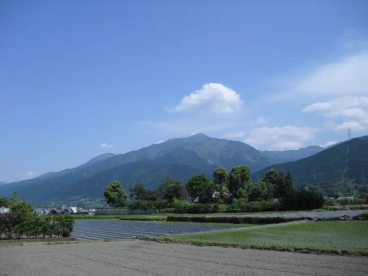
Mount Akaboshi is a 1,453.2 m peak in Shikokuchūō City, Ehime Prefecture, the principal summit of the Hōō Range that branches northeast from the Ishizuchi Mountains. Together with Mount Toyouke and Mount Futatsu it is one of the "Three Mountains of Doi." Its symmetrical cone has earned it the nickname Iyo-Kofuji (Little Fuji of Iyo); the Ōji Gorge route on the north flank passes a series of waterfalls including Senjō-no-taki, while the broad grassy summit looks out over the Niihama and Doi townscapes and the Seto Inland Sea. The mountain is included in the One Hundred Famous Mountains of Shikoku.
Mount Akaboshi at a glance
- Weather: The most settled day in the next 7 days is Sun, November 8: clear, gusts up to 7 m/s.
- Route: The shortest is Mount Akaboshi, the Iyo Kofuji, Oji Gorge Route Return: about 5 h 51 min, 7.9 km, about 1,140 m of climbing.
Mount Akaboshi weather (hourly, 14 days)
Sunrise today 06:28, sunset 17:12
| Tue, 11/3 | Wed, 11/4 | Thu, 11/5 | Fri, 11/6 | Sat, 11/7 | Sun, 11/8 | Mon, 11/9 | Tue, 11/10 | Wed, 11/11 | Thu, 11/12 | Fri, 11/13 | Sat, 11/14 | Sun, 11/15 | Mon, 11/16 | Tue, 11/17 | |||||||||||||||||||||||||||||||||||||||||||||||||||||||||||||||||||||||
|---|---|---|---|---|---|---|---|---|---|---|---|---|---|---|---|---|---|---|---|---|---|---|---|---|---|---|---|---|---|---|---|---|---|---|---|---|---|---|---|---|---|---|---|---|---|---|---|---|---|---|---|---|---|---|---|---|---|---|---|---|---|---|---|---|---|---|---|---|---|---|---|---|---|---|---|---|---|---|---|---|---|---|---|---|---|
| Japan time | 21 | 23 | 1 | 3 | 5 | 7 | 9 | 11 | 13 | 15 | 17 | 19 | 21 | 0 | 3 | 6 | 9 | 12 | 15 | 18 | 21 | 0 | 3 | 6 | 9 | 12 | 15 | 18 | 21 | 0 | 3 | 6 | 9 | 12 | 15 | 18 | 21 | 0 | 3 | 6 | 9 | 12 | 15 | 18 | 21 | 0 | 3 | 6 | 9 | 12 | 15 | 21 | 3 | 9 | 15 | 21 | 3 | 9 | 15 | 21 | 3 | 9 | 15 | 21 | 3 | 9 | 15 | 21 | 3 | 9 | 15 | 21 | 3 | 9 | 15 | 21 | 3 | 9 | 15 | 21 | 3 | 9 | 15 | 21 | |
  | | |   |   |   |   | | | | | | |   | | |   |   | | | | |   |   | | |  |  | | | | | | | | | | | | | | | | | | | | | | |   | | | | | | | | | | | | | | |   | |  | | | | | | | | | | | | | | | |  | ||
| Temperature | °C | 5° | 5° | 5° | 5° | 5° | 5° | 6° | 7° | 8° | 8° | 7° | 7° | 6° | 7° | 6° | 6° | 9° | 11° | 11° | 9° | 9° | 9° | 7° | 6° | 8° | 9° | 9° | 7° | 4° | 4° | 3° | 3° | 3° | 5° | 5° | 3° | 2° | 1° | 1° | 1° | 3° | 5° | 5° | 3° | 3° | 3° | 3° | 4° | 6° | 7° | 6° | 3° | 1° | 5° | 6° | 3° | 1° | 2° | 4° | 2° | 1° | 3° | 5° | 3° | 2° | 3° | 6° | 1° | -1° | 4° | 7° | 3° | 3° | 8° | 9° | 7° | 8° | 7° | 9° | 4° | 1° | 1° | 4° | 1° |
| Precipitation | mm | 0.2 | 1.7 | 1.6 | 0.2 | 1.2 | 1.3 | 1.7 | 1.9 | 1.1 | 0.6 | 0.3 | 0.1 | 0.9 | 0.2 | 0.8 | 0.9 | 0.2 | 0.3 | 0.2 | 0.6 | 1.1 | 0.5 | 3.4 | 0.1 | 1.3 | 1.3 | 3.0 | 0.2 | ||||||||||||||||||||||||||||||||||||||||||||||||||||||||
| New snow | cm | ||||||||||||||||||||||||||||||||||||||||||||||||||||||||||||||||||||||||||||||||||||
| Snow depth | cm | 0 | 0 | 0 | 0 | 0 | 0 | 0 | 0 | 0 | 0 | 0 | 0 | 0 | 0 | 0 | 0 | 0 | 0 | 0 | 0 | 0 | 0 | 0 | 0 | 0 | 0 | 0 | 0 | 0 | 0 | 0 | 0 | 0 | 0 | 0 | 0 | 0 | 0 | 0 | 0 | 0 | 0 | 0 | 0 | 0 | 0 | 0 | 0 | 0 | 0 | 0 | 0 | 0 | 0 | 0 | 0 | 0 | 0 | 0 | 0 | 0 | 0 | 0 | 0 | 0 | 0 | 0 | 0 | 0 | 0 | 0 | 0 | 0 | 0 | 0 | 0 | 0 | 0 | 0 | 0 | 0 | 0 | 0 | 0 |
| Wind | m/s | 2 | 1 | 1 | 1 | 2 | 1 | 2 | 2 | 2 | 2 | 1 | 1 | 0 | 2 | 1 | 1 | 1 | 2 | 1 | 1 | 1 | 3 | 4 | 4 | 5 | 6 | 6 | 6 | 5 | 5 | 5 | 5 | 5 | 4 | 3 | 3 | 2 | 1 | 1 | 2 | 3 | 3 | 3 | 2 | 1 | 1 | 1 | 1 | 1 | 3 | 1 | 1 | 3 | 3 | 4 | 5 | 5 | 3 | 1 | 2 | 1 | 2 | 1 | 2 | 2 | 2 | 3 | 2 | 1 | 1 | 2 | 2 | 2 | 1 | 1 | 1 | 2 | 4 | 3 | 4 | 2 | 2 | 2 | 1 |
| Wind gusts | m/s | 5 | 5 | 3 | 4 | 4 | 5 | 5 | 7 | 5 | 5 | 4 | 3 | 3 | 4 | 4 | 3 | 4 | 5 | 5 | 6 | 7 | 8 | 14 | 11 | 13 | 13 | 14 | 14 | 14 | 13 | 13 | 12 | 13 | 13 | 11 | 9 | 8 | 6 | 4 | 5 | 7 | 7 | 7 | 7 | 5 | 4 | 4 | 5 | 5 | 7 | 7 | 7 | 6 | 7 | 11 | 12 | 13 | 12 | 9 | 6 | 4 | 5 | 6 | 5 | 7 | 7 | 9 | 9 | 6 | 5 | 6 | 5 | 6 | 7 | 9 | 8 | 6 | 10 | 10 | 11 | 9 | 5 | 6 | 5 |
| Wind dir. | ↓ | ↓ | ↓ | ↓ | ↓ | ↓ | ↓ | ↓ | ↓ | ↓ | ↓ | ↓ | ↓ | ↓ | ↓ | ↓ | ↓ | ↓ | ↓ | ↓ | ↓ | ↓ | ↓ | ↓ | ↓ | ↓ | ↓ | ↓ | ↓ | ↓ | ↓ | ↓ | ↓ | ↓ | ↓ | ↓ | ↓ | ↓ | ↓ | ↓ | ↓ | ↓ | ↓ | ↓ | ↓ | ↓ | ↓ | ↓ | ↓ | ↓ | ↓ | ↓ | ↓ | ↓ | ↓ | ↓ | ↓ | ↓ | ↓ | ↓ | ↓ | ↓ | ↓ | ↓ | ↓ | ↓ | ↓ | ↓ | ↓ | ↓ | ↓ | ↓ | ↓ | ↓ | ↓ | ↓ | ↓ | ↓ | ↓ | ↓ | ↓ | ↓ | ↓ | ↓ | |
Mount Akaboshi hiking routes
- Mount Akaboshi, the Iyo Kofuji, Oji Gorge Route Return 7.9 km · Ascent 1,138 m 野田登山口 (parking)
- Mount Akaboshi and Mount Toyouke from Noda Trailhead 10.1 km · Ascent 1,278 m 野田登山口 (parking)
Hiking times are estimates calculated from the terrain.
Huts, campsites and lodging near Mount Akaboshi
Campsites
- 富郷キャンプ場
- きんこん館
Lists that include Mount Akaboshi
100 Fujis of Japan · Shikoku 100 Famous Mountains · Elevations of 1003 Mountains of Japan · 1000 Mountains of Japan
Mount Akaboshi facts
- Also known as
- 伊予小富士
- Elevation
- 1,453 m
- Location
- Shikokuchūō-shi, Ehime
33.919374, 133.457955 - Website
- www.cosmos-network.jp
- Wikipedia
- ja.wikipedia.org