
Mt. Takegawadake
武川岳
Yokoze, Saitama / Hannō, Saitama · Elevation 1,052 m
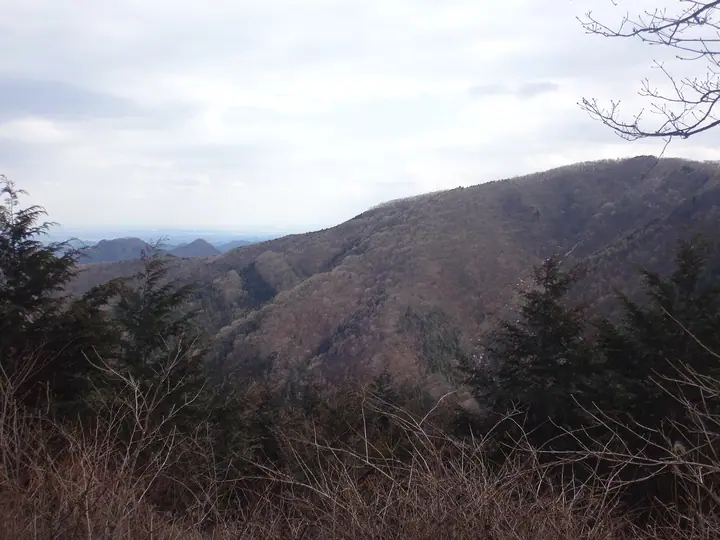
Takegawadake is a 1,051.7-meter peak in the Oku-Musashi range, on the border of Hanno City and Yokoze Town, Chichibu District, Saitama Prefecture, and is the source of the Yokoze River. Despite its 'dake' suffix the peak has a gentle profile, with a broad summit clearing equipped with benches and views south toward the Naguri and Okutama regions. A katakuri (dogtooth violet) colony grows in a grove just west of the summit near Tsumasaka Pass. Two main routes are popular: from Nago in Hanno via Mae-Takegawa, or a long traverse from Ashigakubo Station via Mount Futago, Yakeyama, and Tsutaiwayama. The peak is included in many major Kanto-area lists, including 'Kanto Hyakumeizan' and 'Nihon no Yama 1000'.
Mt. Takegawadake at a glance
- Weather: The most settled day in the next 7 days is Fri, November 6: clear, gusts up to 6 m/s.
Mt. Takegawadake weather (hourly, 14 days)
Sunrise today 06:07, sunset 16:47
| Tue, 11/3 | Wed, 11/4 | Thu, 11/5 | Fri, 11/6 | Sat, 11/7 | Sun, 11/8 | Mon, 11/9 | Tue, 11/10 | Wed, 11/11 | Thu, 11/12 | Fri, 11/13 | Sat, 11/14 | Sun, 11/15 | Mon, 11/16 | Tue, 11/17 | |||||||||||||||||||||||||||||||||||||||||||||||||||||||||||||||||||||||
|---|---|---|---|---|---|---|---|---|---|---|---|---|---|---|---|---|---|---|---|---|---|---|---|---|---|---|---|---|---|---|---|---|---|---|---|---|---|---|---|---|---|---|---|---|---|---|---|---|---|---|---|---|---|---|---|---|---|---|---|---|---|---|---|---|---|---|---|---|---|---|---|---|---|---|---|---|---|---|---|---|---|---|---|---|---|
| Japan time | 15 | 17 | 19 | 21 | 23 | 1 | 3 | 5 | 7 | 9 | 11 | 13 | 15 | 18 | 21 | 0 | 3 | 6 | 9 | 12 | 15 | 18 | 21 | 0 | 3 | 6 | 9 | 12 | 15 | 18 | 21 | 0 | 3 | 6 | 9 | 12 | 15 | 18 | 21 | 0 | 3 | 6 | 9 | 12 | 15 | 18 | 21 | 0 | 3 | 6 | 9 | 15 | 21 | 3 | 9 | 15 | 21 | 3 | 9 | 15 | 21 | 3 | 9 | 15 | 21 | 3 | 9 | 15 | 21 | 3 | 9 | 15 | 21 | 3 | 9 | 15 | 21 | 3 | 9 | 15 | 21 | 3 | 9 | 15 | |
  |   | |   | | | | | | | | | | | | | | |   |   |   |   |   |   |  | |  | |   | | | | | | | | | | | | | | |   | | | | | | | | | | | | | | | | |   |  | | | | | | | | | | | | | | | |   | | | | | | | ||
| Temperature | °C | 12° | 9° | 8° | 8° | 7° | 7° | 7° | 6° | 7° | 8° | 9° | 9° | 8° | 7° | 7° | 6° | 7° | 7° | 10° | 15° | 12° | 10° | 8° | 8° | 8° | 8° | 15° | 18° | 17° | 12° | 9° | 7° | 5° | 4° | 9° | 11° | 10° | 4° | 2° | 1° | 0° | 0° | 6° | 10° | 8° | 4° | 5° | 4° | 2° | 2° | 5° | 7° | 5° | 3° | 5° | 7° | 4° | 0° | 7° | 8° | 2° | -1° | 7° | 8° | 5° | 1° | 9° | 8° | 0° | -2° | 5° | 8° | 1° | 0° | 6° | 9° | 6° | 6° | 13° | 14° | 6° | 3° | 4° | 6° |
| Precipitation | mm | 0.2 | 0.7 | 1.0 | 0.2 | 0.3 | 0.6 | 5 | 13 | 14 | 2.8 | 0.6 | 1.1 | 0.2 | 0.2 | 0.2 | 1.3 | 0.2 | 2.7 | 14 | |||||||||||||||||||||||||||||||||||||||||||||||||||||||||||||||||
| New snow | cm | ||||||||||||||||||||||||||||||||||||||||||||||||||||||||||||||||||||||||||||||||||||
| Snow depth | cm | 0 | 0 | 0 | 0 | 0 | 0 | 0 | 0 | 0 | 0 | 0 | 0 | 0 | 0 | 0 | 0 | 0 | 0 | 0 | 0 | 0 | 0 | 0 | 0 | 0 | 0 | 0 | 0 | 0 | 0 | 0 | 0 | 0 | 0 | 0 | 0 | 0 | 0 | 0 | 0 | 0 | 0 | 0 | 0 | 0 | 0 | 0 | 0 | 0 | 0 | 0 | 0 | 0 | 0 | 0 | 0 | 0 | 0 | 0 | 0 | 0 | 0 | 0 | 0 | 0 | 0 | 0 | 0 | 0 | 0 | 0 | 0 | 0 | 0 | 0 | 0 | 0 | 0 | 0 | 0 | 0 | 0 | 0 | 0 |
| Wind | m/s | 2 | 1 | 1 | 1 | 0 | 1 | 1 | 1 | 1 | 1 | 2 | 2 | 2 | 1 | 1 | 1 | 2 | 2 | 2 | 1 | 2 | 0 | 1 | 1 | 1 | 1 | 1 | 1 | 1 | 1 | 1 | 1 | 1 | 1 | 2 | 4 | 3 | 0 | 1 | 1 | 1 | 1 | 2 | 1 | 2 | 1 | 0 | 1 | 1 | 1 | 1 | 1 | 1 | 1 | 1 | 3 | 0 | 2 | 7 | 6 | 2 | 1 | 0 | 1 | 1 | 2 | 3 | 5 | 1 | 1 | 1 | 2 | 1 | 2 | 1 | 1 | 0 | 1 | 1 | 5 | 4 | 1 | 1 | 2 |
| Wind gusts | m/s | 7 | 4 | 3 | 2 | 2 | 3 | 3 | 3 | 2 | 4 | 5 | 6 | 6 | 5 | 3 | 3 | 5 | 5 | 6 | 7 | 5 | 3 | 3 | 3 | 3 | 3 | 4 | 6 | 5 | 4 | 4 | 5 | 5 | 5 | 6 | 10 | 11 | 9 | 3 | 4 | 5 | 5 | 5 | 6 | 7 | 6 | 3 | 2 | 3 | 3 | 4 | 7 | 4 | 4 | 4 | 8 | 8 | 4 | 21 | 22 | 16 | 5 | 4 | 7 | 4 | 5 | 9 | 14 | 13 | 5 | 5 | 7 | 5 | 4 | 4 | 6 | 3 | 6 | 5 | 14 | 13 | 12 | 4 | 7 |
| Wind dir. | ↓ | ↓ | ↓ | ↓ | ↓ | ↓ | ↓ | ↓ | ↓ | ↓ | ↓ | ↓ | ↓ | ↓ | ↓ | ↓ | ↓ | ↓ | ↓ | ↓ | ↓ | ↓ | ↓ | ↓ | ↓ | ↓ | ↓ | ↓ | ↓ | ↓ | ↓ | ↓ | ↓ | ↓ | ↓ | ↓ | ↓ | ↓ | ↓ | ↓ | ↓ | ↓ | ↓ | ↓ | ↓ | ↓ | ↓ | ↓ | ↓ | ↓ | ↓ | ↓ | ↓ | ↓ | ↓ | ↓ | ↓ | ↓ | ↓ | ↓ | ↓ | ↓ | ↓ | ↓ | ↓ | ↓ | ↓ | ↓ | ↓ | ↓ | ↓ | ↓ | ↓ | ↓ | ↓ | ↓ | ↓ | ↓ | ↓ | ↓ | ↓ | ↓ | ↓ | ↓ | |
Huts, campsites and lodging near Mt. Takegawadake
Mountain huts
- Naguri Genki Plaza Emergency Shelter
Campsites
- Naguri Genki Plaza
- Shiraiwa Mountain Stream Camping Ground
Lodging
- やしき荘
Lists that include Mt. Takegawadake
Kanto 100 Famous Mountains · 50 Mountains of Saitama Prefecture · 1000 Mountains of Japan
Mt. Takegawadake facts
- Also known as
- 箒平 · ホーキ平 · ホウキ平
- Elevation
- 1,052 m
- Location
- Yokoze, Saitama / Hannō, Saitama
35.936942, 139.130323 - Website
- www.yokoze.org
- Trail Map
- www.yokoze.org (PDF)
- Wikipedia
- ja.wikipedia.org