
Mt. Migitagadake
右田ヶ岳
Hōfu-shi, Yamaguchi · Elevation 426 m
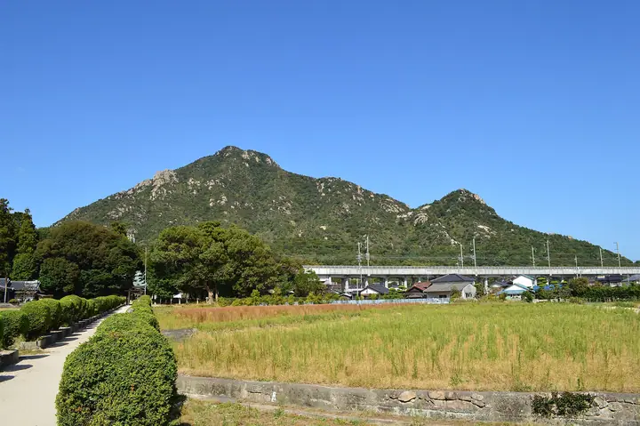
Migitagadake is a 426 m peak in Hōfu City, Yamaguchi Prefecture. Despite its modest height it is celebrated for the wild granite outcrops that scar its flanks—a profile clearly visible from the Sanyō Shinkansen passing below. A late-Kamakura mountain castle of the Migita branch of the Ōuchi clan once stood on its southern peak, and a series of thirty-three Kannon statues carved on natural rock leads from Tentokuji at the foot up to the Maedake summit. Trails climb from the Tsukahara, Tentokuji and Katsusaka trailheads, and the peak ranked second among the most-climbed mountains in the Chūgoku region in 2022 and 2023. It is included in the Chūgoku Hyakumeizan, the Yamaguchi Hyakumeizan and the Bōchō Hyakuzan.
Mt. Migitagadake at a glance
- Weather: The most settled day in the next 7 days is Sun, November 8: clear, gusts up to 6 m/s.
- Route: The shortest is Migitagadake via the Tentokuji and Tsukahara Routes: about 2 h 27 min, 3.9 km, about 440 m of climbing.
Mt. Migitagadake weather (hourly, 14 days)
Sunrise today 06:34, sunset 17:20
| Tue, 11/3 | Wed, 11/4 | Thu, 11/5 | Fri, 11/6 | Sat, 11/7 | Sun, 11/8 | Mon, 11/9 | Tue, 11/10 | Wed, 11/11 | Thu, 11/12 | Fri, 11/13 | Sat, 11/14 | Sun, 11/15 | Mon, 11/16 | Tue, 11/17 | |||||||||||||||||||||||||||||||||||||||||||||||||||||||||||||||||||||||
|---|---|---|---|---|---|---|---|---|---|---|---|---|---|---|---|---|---|---|---|---|---|---|---|---|---|---|---|---|---|---|---|---|---|---|---|---|---|---|---|---|---|---|---|---|---|---|---|---|---|---|---|---|---|---|---|---|---|---|---|---|---|---|---|---|---|---|---|---|---|---|---|---|---|---|---|---|---|---|---|---|---|---|---|---|---|
| Japan time | 15 | 17 | 19 | 21 | 23 | 1 | 3 | 5 | 7 | 9 | 11 | 13 | 15 | 18 | 21 | 0 | 3 | 6 | 9 | 12 | 15 | 18 | 21 | 0 | 3 | 6 | 9 | 12 | 15 | 18 | 21 | 0 | 3 | 6 | 9 | 12 | 15 | 18 | 21 | 0 | 3 | 6 | 9 | 12 | 15 | 18 | 21 | 0 | 3 | 6 | 9 | 15 | 21 | 3 | 9 | 15 | 21 | 3 | 9 | 15 | 21 | 3 | 9 | 15 | 21 | 3 | 9 | 15 | 21 | 3 | 9 | 15 | 21 | 3 | 9 | 15 | 21 | 3 | 9 | 15 | 21 | 3 | 9 | 15 | |
  |   |   | | | |   | | | | | | | |   | | | | |   | |   | | |  | |  | | | | | | | | | | | | | | | | | | | | | | | | |   |   | | | | | |   | | |  | | | | | | | | | | | |   |   | | | | | | | | | | ||
| Temperature | °C | 17° | 14° | 13° | 12° | 12° | 11° | 10° | 11° | 10° | 13° | 16° | 16° | 17° | 14° | 14° | 13° | 13° | 13° | 15° | 16° | 16° | 16° | 16° | 14° | 13° | 12° | 16° | 16° | 14° | 11° | 10° | 9° | 8° | 7° | 10° | 12° | 12° | 9° | 6° | 5° | 5° | 5° | 10° | 13° | 13° | 12° | 11° | 10° | 10° | 10° | 12° | 14° | 9° | 7° | 12° | 13° | 11° | 8° | 10° | 12° | 7° | 4° | 10° | 14° | 8° | 6° | 12° | 14° | 9° | 7° | 10° | 14° | 11° | 13° | 13° | 15° | 15° | 13° | 15° | 16° | 10° | 9° | 10° | 13° |
| Precipitation | mm | 0.3 | 0.2 | 1.5 | 0.3 | 3.2 | 0.2 | 0.3 | 1.0 | 27 | 12 | ||||||||||||||||||||||||||||||||||||||||||||||||||||||||||||||||||||||||||
| New snow | cm | ||||||||||||||||||||||||||||||||||||||||||||||||||||||||||||||||||||||||||||||||||||
| Snow depth | cm | 0 | 0 | 0 | 0 | 0 | 0 | 0 | 0 | 0 | 0 | 0 | 0 | 0 | 0 | 0 | 0 | 0 | 0 | 0 | 0 | 0 | 0 | 0 | 0 | 0 | 0 | 0 | 0 | 0 | 0 | 0 | 0 | 0 | 0 | 0 | 0 | 0 | 0 | 0 | 0 | 0 | 0 | 0 | 0 | 0 | 0 | 0 | 0 | 0 | 0 | 0 | 0 | 0 | 0 | 0 | 0 | 0 | 0 | 0 | 0 | 0 | 0 | 0 | 0 | 0 | 0 | 0 | 0 | 0 | 0 | 0 | 0 | 0 | 0 | 0 | 0 | 0 | 0 | 0 | 0 | 0 | 0 | 0 | 0 |
| Wind | m/s | 4 | 4 | 5 | 4 | 4 | 4 | 3 | 2 | 2 | 3 | 4 | 4 | 2 | 2 | 3 | 1 | 3 | 2 | 2 | 2 | 5 | 3 | 4 | 5 | 5 | 4 | 6 | 7 | 7 | 5 | 5 | 5 | 4 | 4 | 4 | 4 | 4 | 3 | 3 | 3 | 3 | 2 | 2 | 1 | 2 | 0 | 1 | 2 | 2 | 3 | 2 | 4 | 2 | 2 | 3 | 6 | 3 | 5 | 3 | 4 | 2 | 1 | 1 | 4 | 2 | 1 | 1 | 1 | 3 | 3 | 3 | 3 | 3 | 5 | 6 | 5 | 2 | 4 | 4 | 5 | 4 | 2 | 1 | 2 |
| Wind gusts | m/s | 10 | 9 | 9 | 9 | 8 | 7 | 7 | 5 | 5 | 6 | 9 | 9 | 7 | 5 | 7 | 6 | 5 | 5 | 6 | 6 | 11 | 11 | 7 | 9 | 10 | 9 | 12 | 14 | 14 | 13 | 9 | 10 | 10 | 9 | 9 | 10 | 10 | 8 | 5 | 6 | 5 | 5 | 5 | 4 | 6 | 6 | 3 | 4 | 5 | 5 | 5 | 9 | 9 | 5 | 6 | 12 | 12 | 10 | 10 | 9 | 9 | 4 | 3 | 8 | 8 | 3 | 4 | 6 | 8 | 7 | 6 | 6 | 6 | 9 | 12 | 13 | 10 | 7 | 9 | 12 | 9 | 8 | 5 | 5 |
| Wind dir. | ↓ | ↓ | ↓ | ↓ | ↓ | ↓ | ↓ | ↓ | ↓ | ↓ | ↓ | ↓ | ↓ | ↓ | ↓ | ↓ | ↓ | ↓ | ↓ | ↓ | ↓ | ↓ | ↓ | ↓ | ↓ | ↓ | ↓ | ↓ | ↓ | ↓ | ↓ | ↓ | ↓ | ↓ | ↓ | ↓ | ↓ | ↓ | ↓ | ↓ | ↓ | ↓ | ↓ | ↓ | ↓ | ↓ | ↓ | ↓ | ↓ | ↓ | ↓ | ↓ | ↓ | ↓ | ↓ | ↓ | ↓ | ↓ | ↓ | ↓ | ↓ | ↓ | ↓ | ↓ | ↓ | ↓ | ↓ | ↓ | ↓ | ↓ | ↓ | ↓ | ↓ | ↓ | ↓ | ↓ | ↓ | ↓ | ↓ | ↓ | ↓ | ↓ | ↓ | ↓ | |
Mt. Migitagadake hiking routes
- Migitagadake via the Tentokuji and Tsukahara Routes 3.9 km · Ascent 436 m 天徳寺 (parking)
- Mount Migita in Hofu, Loop from Tentokuji past the Rock-Carved Kannon to Tonooka 5.0 km · Ascent 490 m 天徳寺 (parking)
Hiking times are estimates calculated from the terrain.
Huts, campsites and lodging near Mt. Migitagadake
Lodging
- 防府市サイクリングターミナル
- アパホテル
- α-1
- サン防府
- Hofu Junction : Rest
Lists that include Mt. Migitagadake
Chugoku 100 Famous Mountains · Yamaguchi Prefecture 100 Famous Mountains
Mt. Migitagadake facts
- Elevation
- 426 m
- Location
- Hōfu-shi, Yamaguchi
34.086547, 131.556961 - Website
- yamaguchi-tourism.jp
- Trail Map
- tentokuji.or.jp
- Access Information
- tentokuji.or.jp
- Wikipedia
- ja.wikipedia.org