
Mt. Kinpouzan
金峯山
Minamisatsuma, Kagoshima · Elevation 636 m
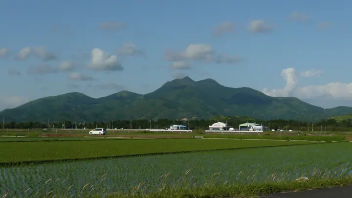
Kinpōzan is a 636 m mountain in Minamisatsuma City, Kagoshima Prefecture, made up of three peaks — Hongatake, Higashidake and Kitadake. A long-revered mountain of Shugendō asceticism, its Kinpō Shrine near the summit enshrines Zaō-Gongen. Together with Mt. Kaimon and Mt. Noma it is counted among the "Three Famous Mountains of the Satsuma Peninsula" and is listed in the Kyushu Hyakumeizan. Locally nicknamed Bijin-dake ("Beauty Peak") for its reclining-figure profile, its summit gives sweeping views from Fukiagehama beach to Sakurajima.
Mt. Kinpouzan at a glance
- Weather: The most settled day in the next 7 days is Sun, November 8: clear, gusts up to 9 m/s. Fri, Nov 6: strong wind (gusts up to 16 m/s).
- Route: The shortest is Mount Kinpo in Minamisatsuma, Three-Summit Round of the Main, East and North Peaks from the Upper Car Park: about 1 h 11 min, 1.7 km, about 210 m of climbing.
Mt. Kinpouzan weather (hourly, 14 days)
Sunrise today 06:35, sunset 17:29
| Tue, 11/3 | Wed, 11/4 | Thu, 11/5 | Fri, 11/6 | Sat, 11/7 | Sun, 11/8 | Mon, 11/9 | Tue, 11/10 | Wed, 11/11 | Thu, 11/12 | Fri, 11/13 | Sat, 11/14 | Sun, 11/15 | Mon, 11/16 | Tue, 11/17 | |||||||||||||||||||||||||||||||||||||||||||||||||||||||||||||||||||||||
|---|---|---|---|---|---|---|---|---|---|---|---|---|---|---|---|---|---|---|---|---|---|---|---|---|---|---|---|---|---|---|---|---|---|---|---|---|---|---|---|---|---|---|---|---|---|---|---|---|---|---|---|---|---|---|---|---|---|---|---|---|---|---|---|---|---|---|---|---|---|---|---|---|---|---|---|---|---|---|---|---|---|---|---|---|---|
| Japan time | 21 | 23 | 1 | 3 | 5 | 7 | 9 | 11 | 13 | 15 | 17 | 19 | 21 | 0 | 3 | 6 | 9 | 12 | 15 | 18 | 21 | 0 | 3 | 6 | 9 | 12 | 15 | 18 | 21 | 0 | 3 | 6 | 9 | 12 | 15 | 18 | 21 | 0 | 3 | 6 | 9 | 12 | 15 | 18 | 21 | 0 | 3 | 6 | 9 | 12 | 15 | 21 | 3 | 9 | 15 | 21 | 3 | 9 | 15 | 21 | 3 | 9 | 15 | 21 | 3 | 9 | 15 | 21 | 3 | 9 | 15 | 21 | 3 | 9 | 15 | 21 | 3 | 9 | 15 | 21 | 3 | 9 | 15 | 21 | |
  |   | | |   |   |   |   | |   | |   | | | | |   |   | |   | | | | |  | | | | | | |  | | | | | | | | | | | | | | |   | | | | | |   | | | | | | | | | | | |  | | | | | | | | | | | | | | |  | | | | | ||
| Temperature | °C | 12° | 12° | 12° | 13° | 12° | 12° | 14° | 17° | 18° | 19° | 17° | 15° | 15° | 15° | 15° | 14° | 16° | 20° | 18° | 17° | 16° | 15° | 14° | 14° | 15° | 17° | 16° | 14° | 13° | 11° | 9° | 7° | 9° | 12° | 12° | 9° | 6° | 6° | 6° | 7° | 12° | 15° | 14° | 13° | 12° | 11° | 12° | 11° | 14° | 16° | 14° | 12° | 8° | 11° | 13° | 9° | 7° | 10° | 12° | 7° | 5° | 9° | 13° | 8° | 5° | 10° | 15° | 9° | 8° | 13° | 17° | 14° | 14° | 14° | 16° | 15° | 14° | 14° | 16° | 11° | 9° | 13° | 15° | 11° |
| Precipitation | mm | 0.7 | 0.3 | 1.2 | 0.6 | 0.2 | 2.2 | 0.6 | 0.2 | 0.2 | 0.1 | 0.3 | 2.2 | 11 | 23 | 0.5 | |||||||||||||||||||||||||||||||||||||||||||||||||||||||||||||||||||||
| New snow | cm | ||||||||||||||||||||||||||||||||||||||||||||||||||||||||||||||||||||||||||||||||||||
| Snow depth | cm | 0 | 0 | 0 | 0 | 0 | 0 | 0 | 0 | 0 | 0 | 0 | 0 | 0 | 0 | 0 | 0 | 0 | 0 | 0 | 0 | 0 | 0 | 0 | 0 | 0 | 0 | 0 | 0 | 0 | 0 | 0 | 0 | 0 | 0 | 0 | 0 | 0 | 0 | 0 | 0 | 0 | 0 | 0 | 0 | 0 | 0 | 0 | 0 | 0 | 0 | 0 | 0 | 0 | 0 | 0 | 0 | 0 | 0 | 0 | 0 | 0 | 0 | 0 | 0 | 0 | 0 | 0 | 0 | 0 | 0 | 0 | 0 | 0 | 0 | 0 | 0 | 0 | 0 | 0 | 0 | 0 | 0 | 0 | 0 |
| Wind | m/s | 1 | 1 | 2 | 3 | 3 | 3 | 3 | 3 | 4 | 4 | 2 | 2 | 4 | 3 | 3 | 3 | 2 | 5 | 5 | 5 | 6 | 5 | 5 | 5 | 5 | 7 | 7 | 6 | 5 | 5 | 4 | 4 | 5 | 5 | 5 | 3 | 1 | 1 | 3 | 3 | 4 | 4 | 3 | 2 | 2 | 2 | 2 | 2 | 2 | 2 | 4 | 3 | 3 | 5 | 6 | 5 | 3 | 4 | 4 | 2 | 0 | 1 | 3 | 2 | 1 | 1 | 2 | 1 | 3 | 3 | 4 | 5 | 4 | 4 | 4 | 3 | 4 | 3 | 5 | 3 | 0 | 0 | 2 | 1 |
| Wind gusts | m/s | 5 | 3 | 3 | 6 | 7 | 7 | 7 | 8 | 9 | 9 | 9 | 5 | 7 | 7 | 7 | 6 | 5 | 10 | 12 | 13 | 12 | 12 | 12 | 12 | 12 | 15 | 16 | 16 | 13 | 11 | 9 | 9 | 11 | 12 | 12 | 10 | 6 | 3 | 5 | 7 | 9 | 9 | 9 | 6 | 5 | 5 | 5 | 4 | 5 | 6 | 8 | 8 | 8 | 12 | 13 | 13 | 10 | 10 | 11 | 10 | 3 | 3 | 8 | 8 | 4 | 4 | 7 | 6 | 5 | 7 | 10 | 9 | 9 | 9 | 10 | 13 | 10 | 9 | 12 | 12 | 5 | 3 | 6 | 6 |
| Wind dir. | ↓ | ↓ | ↓ | ↓ | ↓ | ↓ | ↓ | ↓ | ↓ | ↓ | ↓ | ↓ | ↓ | ↓ | ↓ | ↓ | ↓ | ↓ | ↓ | ↓ | ↓ | ↓ | ↓ | ↓ | ↓ | ↓ | ↓ | ↓ | ↓ | ↓ | ↓ | ↓ | ↓ | ↓ | ↓ | ↓ | ↓ | ↓ | ↓ | ↓ | ↓ | ↓ | ↓ | ↓ | ↓ | ↓ | ↓ | ↓ | ↓ | ↓ | ↓ | ↓ | ↓ | ↓ | ↓ | ↓ | ↓ | ↓ | ↓ | ↓ | ↓ | ↓ | ↓ | ↓ | ↓ | ↓ | ↓ | ↓ | ↓ | ↓ | ↓ | ↓ | ↓ | ↓ | ↓ | ↓ | ↓ | ↓ | ↓ | ↓ | ↓ | ↓ | ↓ | ↓ | |
Mt. Kinpouzan hiking routes
Hiking times are estimates calculated from the terrain.
Lists that include Mt. Kinpouzan
Kyushu 100 Famous Mountains · Elevations of 1003 Mountains of Japan · 1000 Mountains of Japan
Mt. Kinpouzan facts
- Also known as
- 美人岳
- Elevation
- 636 m
- Location
- Minamisatsuma, Kagoshima
31.467778, 130.383044 - Website
- kanko-minamisatsuma.jp
- Wikipedia
- ja.wikipedia.org