
Mt. Kasagata
笠形山
Kamikawa, Hyogo · Elevation 939 m
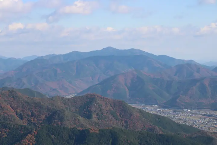
A 939.2 m peak straddling the boundary between Taka Town and Kamikawa Town, with its southern slopes spilling into Ichikawa Town, in Hyogo Prefecture. Its tidy conical shape has earned it the nickname 'Harima Fuji', and it ranks as the second-highest summit in eastern Harima. Five named waterfalls—Hebazura, Nijūga, Shōbu, Aka, and Ryūga—line the climb, alongside Amanjaku-themed legends preserved in springs and grindstone rocks. The whole massif lies within Kasagatayama-Sengamine Prefectural Natural Park, and the peak appears in numerous selections including the Kansai 100, Kinki 100, Furusato Hyogo 100 and Nihon Hyaku-Fuji.
Mt. Kasagata at a glance
- Weather: The most settled day in the next 7 days is Fri, November 6: clear, gusts up to 10 m/s.
- Route: The shortest is Mount Kasagata, the Banshu Fuji, via Henmyo Falls from Green Echo Kasagata: about 4 h 14 min, 6.6 km, about 640 m of climbing.
Mt. Kasagata weather (hourly, 14 days)
Sunrise today 06:23, sunset 17:06
| Tue, 11/3 | Wed, 11/4 | Thu, 11/5 | Fri, 11/6 | Sat, 11/7 | Sun, 11/8 | Mon, 11/9 | Tue, 11/10 | Wed, 11/11 | Thu, 11/12 | Fri, 11/13 | Sat, 11/14 | Sun, 11/15 | Mon, 11/16 | Tue, 11/17 | |||||||||||||||||||||||||||||||||||||||||||||||||||||||||||||||||||||||
|---|---|---|---|---|---|---|---|---|---|---|---|---|---|---|---|---|---|---|---|---|---|---|---|---|---|---|---|---|---|---|---|---|---|---|---|---|---|---|---|---|---|---|---|---|---|---|---|---|---|---|---|---|---|---|---|---|---|---|---|---|---|---|---|---|---|---|---|---|---|---|---|---|---|---|---|---|---|---|---|---|---|---|---|---|---|
| Japan time | 15 | 17 | 19 | 21 | 23 | 1 | 3 | 5 | 7 | 9 | 11 | 13 | 15 | 18 | 21 | 0 | 3 | 6 | 9 | 12 | 15 | 18 | 21 | 0 | 3 | 6 | 9 | 12 | 15 | 18 | 21 | 0 | 3 | 6 | 9 | 12 | 15 | 18 | 21 | 0 | 3 | 6 | 9 | 12 | 15 | 18 | 21 | 0 | 3 | 6 | 9 | 15 | 21 | 3 | 9 | 15 | 21 | 3 | 9 | 15 | 21 | 3 | 9 | 15 | 21 | 3 | 9 | 15 | 21 | 3 | 9 | 15 | 21 | 3 | 9 | 15 | 21 | 3 | 9 | 15 | 21 | 3 | 9 | 15 | |
  | |   | | | | | |  | | |   | | |   |   | | |   |   | | |   | |   |   | | | | |  | | | | | | | | | | | | | |   | | | | | | | | |   | | | | | | | |  | | | | |   | | | | | | | | | | | | | | | | | | ||
| Temperature | °C | 12° | 9° | 8° | 8° | 7° | 7° | 7° | 7° | 7° | 10° | 13° | 14° | 12° | 10° | 10° | 9° | 10° | 9° | 10° | 15° | 15° | 12° | 12° | 11° | 10° | 9° | 11° | 15° | 14° | 8° | 6° | 4° | 3° | 3° | 8° | 9° | 8° | 5° | 2° | 2° | 2° | 2° | 8° | 10° | 10° | 7° | 6° | 6° | 6° | 6° | 9° | 11° | 4° | 3° | 7° | 11° | 4° | 3° | 6° | 7° | 2° | 1° | 7° | 10° | 4° | 3° | 7° | 7° | 2° | 3° | 7° | 11° | 5° | 6° | 10° | 11° | 10° | 10° | 12° | 10° | 5° | 2° | 6° | 7° |
| Precipitation | mm | 1.0 | 0.1 | 4.1 | 0.4 | 0.4 | 0.2 | 0.2 | 0.7 | 0.8 | 0.2 | 1.0 | 0.2 | 0.1 | 0.1 | 0.1 | 0.2 | 0.4 | 7 | 2.7 | 0.3 | 0.5 | |||||||||||||||||||||||||||||||||||||||||||||||||||||||||||||||
| New snow | cm | ||||||||||||||||||||||||||||||||||||||||||||||||||||||||||||||||||||||||||||||||||||
| Snow depth | cm | 0 | 0 | 0 | 0 | 0 | 0 | 0 | 0 | 0 | 0 | 0 | 0 | 0 | 0 | 0 | 0 | 0 | 0 | 0 | 0 | 0 | 0 | 0 | 0 | 0 | 0 | 0 | 0 | 0 | 0 | 0 | 0 | 0 | 0 | 0 | 0 | 0 | 0 | 0 | 0 | 0 | 0 | 0 | 0 | 0 | 0 | 0 | 0 | 0 | 0 | 0 | 0 | 0 | 0 | 0 | 0 | 0 | 0 | 0 | 0 | 0 | 0 | 0 | 0 | 0 | 0 | 0 | 0 | 0 | 0 | 0 | 0 | 0 | 0 | 0 | 0 | 0 | 0 | 0 | 0 | 0 | 0 | 0 | 0 |
| Wind | m/s | 4 | 4 | 4 | 4 | 4 | 4 | 4 | 5 | 5 | 5 | 4 | 4 | 4 | 3 | 3 | 2 | 2 | 2 | 3 | 1 | 0 | 2 | 0 | 1 | 2 | 1 | 1 | 3 | 4 | 2 | 2 | 2 | 1 | 2 | 4 | 5 | 5 | 2 | 1 | 1 | 2 | 1 | 1 | 4 | 4 | 3 | 2 | 2 | 1 | 1 | 0 | 2 | 1 | 1 | 2 | 4 | 2 | 4 | 6 | 5 | 2 | 1 | 0 | 2 | 1 | 1 | 5 | 5 | 3 | 3 | 2 | 2 | 1 | 0 | 1 | 3 | 1 | 1 | 3 | 7 | 6 | 2 | 4 | 3 |
| Wind gusts | m/s | 10 | 10 | 10 | 10 | 9 | 9 | 10 | 11 | 11 | 12 | 12 | 10 | 9 | 8 | 7 | 6 | 5 | 5 | 7 | 6 | 4 | 3 | 4 | 4 | 5 | 4 | 5 | 8 | 10 | 10 | 6 | 5 | 5 | 5 | 9 | 12 | 12 | 11 | 4 | 4 | 4 | 4 | 4 | 10 | 10 | 10 | 6 | 4 | 3 | 3 | 3 | 6 | 5 | 3 | 7 | 11 | 9 | 9 | 15 | 15 | 11 | 5 | 4 | 7 | 6 | 4 | 11 | 14 | 12 | 8 | 9 | 6 | 5 | 3 | 4 | 9 | 8 | 8 | 8 | 17 | 17 | 15 | 10 | 11 |
| Wind dir. | ↓ | ↓ | ↓ | ↓ | ↓ | ↓ | ↓ | ↓ | ↓ | ↓ | ↓ | ↓ | ↓ | ↓ | ↓ | ↓ | ↓ | ↓ | ↓ | ↓ | ↓ | ↓ | ↓ | ↓ | ↓ | ↓ | ↓ | ↓ | ↓ | ↓ | ↓ | ↓ | ↓ | ↓ | ↓ | ↓ | ↓ | ↓ | ↓ | ↓ | ↓ | ↓ | ↓ | ↓ | ↓ | ↓ | ↓ | ↓ | ↓ | ↓ | ↓ | ↓ | ↓ | ↓ | ↓ | ↓ | ↓ | ↓ | ↓ | ↓ | ↓ | ↓ | ↓ | ↓ | ↓ | ↓ | ↓ | ↓ | ↓ | ↓ | ↓ | ↓ | ↓ | ↓ | ↓ | ↓ | ↓ | ↓ | ↓ | ↓ | ↓ | ↓ | ↓ | ↓ | |
Mt. Kasagata hiking routes
Hiking times are estimates calculated from the terrain.
Huts, campsites and lodging near Mt. Kasagata
Mountain huts
- 竜が滝展望台
- 船坂峠
Lodging
- Refresh Park Ichikawa
- かさがた温泉
Lists that include Mt. Kasagata
100 Fujis of Japan · Kansai 100 Famous Mountains · Kinki 100 Famous Mountains · 100 Mountains of Our Home Hyogo · Let’s Climb in Kita-Harima · Elevations of 1003 Mountains of Japan · 1000 Mountains of Japan
Mt. Kasagata facts
- Also known as
- 播磨富士
- Elevation
- 939 m
- Location
- Kamikawa, Hyogo
35.064147, 134.834588 - Website
- kanko.takacho.net
- Trail Map
- kanko.takacho.net
- Wikipedia
- ja.wikipedia.org