
Mount Sengamine
千ヶ峰
Taka, Hyogo / Kamikawa, Hyogo · Elevation 1,005 m
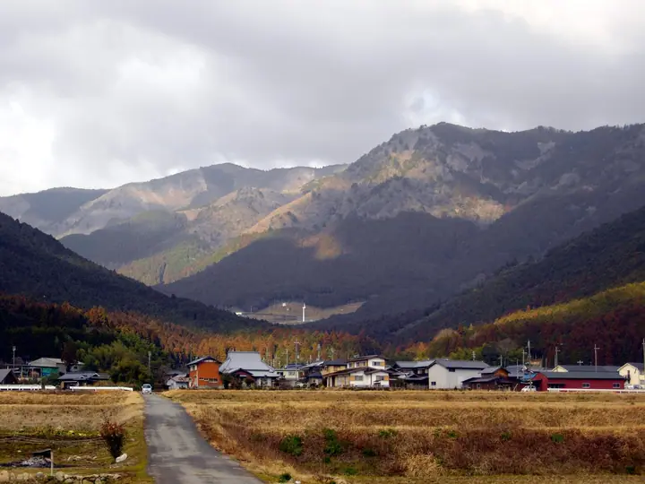
Mount Sengamine is a 1,005.2 m peak on the border between Taka Town in Taka District and Kamikawa Town in Kanzaki District of Hyogo Prefecture, the easternmost 1,000 m summit of the Chugoku Mountains and the highest peak of Kita-Harima. It forms the watershed between the Kako and Ichi River systems, and from its open summit a 360-degree panorama reaches as far as the Akashi-Kaikyo Bridge on clear days. The peak is climbed via the Mitani, Ichihara and Iwazarikami trailheads, and is selected for the 100 Famous Mountains of Kansai, the Furusato Hyogo 100 and the Taka Three Mountains, among other lists.
Mount Sengamine at a glance
- Weather: The most settled day in the next 7 days is Mon, November 9: clear, gusts up to 9 m/s.
- Route: The shortest is Mount Sengamine Return via Mitani Course: about 2 h 10 min, 3.6 km, about 610 m of climbing.
Mount Sengamine weather (hourly, 14 days)
Sunrise today 06:23, sunset 17:05
| Tue, 11/3 | Wed, 11/4 | Thu, 11/5 | Fri, 11/6 | Sat, 11/7 | Sun, 11/8 | Mon, 11/9 | Tue, 11/10 | Wed, 11/11 | Thu, 11/12 | Fri, 11/13 | Sat, 11/14 | Sun, 11/15 | Mon, 11/16 | Tue, 11/17 | |||||||||||||||||||||||||||||||||||||||||||||||||||||||||||||||||||||||
|---|---|---|---|---|---|---|---|---|---|---|---|---|---|---|---|---|---|---|---|---|---|---|---|---|---|---|---|---|---|---|---|---|---|---|---|---|---|---|---|---|---|---|---|---|---|---|---|---|---|---|---|---|---|---|---|---|---|---|---|---|---|---|---|---|---|---|---|---|---|---|---|---|---|---|---|---|---|---|---|---|---|---|---|---|---|
| Japan time | 15 | 17 | 19 | 21 | 23 | 1 | 3 | 5 | 7 | 9 | 11 | 13 | 15 | 18 | 21 | 0 | 3 | 6 | 9 | 12 | 15 | 18 | 21 | 0 | 3 | 6 | 9 | 12 | 15 | 18 | 21 | 0 | 3 | 6 | 9 | 12 | 15 | 18 | 21 | 0 | 3 | 6 | 9 | 12 | 15 | 18 | 21 | 0 | 3 | 6 | 9 | 15 | 21 | 3 | 9 | 15 | 21 | 3 | 9 | 15 | 21 | 3 | 9 | 15 | 21 | 3 | 9 | 15 | 21 | 3 | 9 | 15 | 21 | 3 | 9 | 15 | 21 | 3 | 9 | 15 | 21 | 3 | 9 | 15 | |
  |   |   | | | | | | | |  |   | |   |   |   | | | |   |   | | |   | | | | | | |  | | | | |   | | | | | | | | | | | | | | | | |   | | | | |   | | | |  | | | | | | | | | | | | | | | | | | | | | | | ||
| Temperature | °C | 11° | 9° | 7° | 7° | 6° | 6° | 7° | 6° | 7° | 10° | 12° | 13° | 12° | 9° | 9° | 9° | 10° | 9° | 10° | 16° | 15° | 12° | 11° | 11° | 10° | 10° | 12° | 15° | 13° | 8° | 6° | 5° | 4° | 3° | 7° | 8° | 7° | 4° | 3° | 3° | 3° | 3° | 8° | 10° | 9° | 6° | 6° | 6° | 6° | 6° | 9° | 10° | 4° | 2° | 8° | 11° | 4° | 2° | 5° | 6° | 3° | 2° | 7° | 10° | 4° | 3° | 5° | 7° | 3° | 2° | 7° | 11° | 5° | 6° | 10° | 11° | 11° | 11° | 11° | 9° | 4° | 2° | 5° | 6° |
| Precipitation | mm | 0.2 | 0.8 | 0.1 | 3.4 | 0.5 | 0.2 | 1.3 | 0.8 | 0.7 | 1.2 | 0.6 | 0.2 | 0.5 | 0.3 | 0.4 | 0.8 | 2.9 | 11 | 2.1 | 0.3 | 1.4 | 1.9 | ||||||||||||||||||||||||||||||||||||||||||||||||||||||||||||||
| New snow | cm | ||||||||||||||||||||||||||||||||||||||||||||||||||||||||||||||||||||||||||||||||||||
| Snow depth | cm | 0 | 0 | 0 | 0 | 0 | 0 | 0 | 0 | 0 | 0 | 0 | 0 | 0 | 0 | 0 | 0 | 0 | 0 | 0 | 0 | 0 | 0 | 0 | 0 | 0 | 0 | 0 | 0 | 0 | 0 | 0 | 0 | 0 | 0 | 0 | 0 | 0 | 0 | 0 | 0 | 0 | 0 | 0 | 0 | 0 | 0 | 0 | 0 | 0 | 0 | 0 | 0 | 0 | 0 | 0 | 0 | 0 | 0 | 0 | 0 | 0 | 0 | 0 | 0 | 0 | 0 | 0 | 0 | 0 | 0 | 0 | 0 | 0 | 0 | 0 | 0 | 0 | 0 | 0 | 0 | 0 | 0 | 0 | 0 |
| Wind | m/s | 4 | 3 | 3 | 3 | 3 | 3 | 4 | 4 | 4 | 4 | 4 | 3 | 3 | 2 | 1 | 1 | 0 | 1 | 2 | 1 | 1 | 1 | 1 | 1 | 2 | 1 | 2 | 4 | 4 | 2 | 3 | 3 | 3 | 2 | 5 | 5 | 5 | 2 | 1 | 2 | 1 | 1 | 3 | 4 | 5 | 2 | 1 | 1 | 1 | 1 | 1 | 3 | 1 | 1 | 2 | 4 | 3 | 6 | 7 | 5 | 2 | 1 | 1 | 1 | 1 | 1 | 5 | 6 | 3 | 3 | 2 | 3 | 2 | 2 | 3 | 4 | 3 | 2 | 4 | 6 | 6 | 4 | 5 | 3 |
| Wind gusts | m/s | 10 | 9 | 8 | 8 | 7 | 8 | 9 | 9 | 9 | 11 | 11 | 10 | 9 | 7 | 4 | 4 | 4 | 4 | 5 | 6 | 4 | 3 | 3 | 7 | 5 | 6 | 6 | 10 | 11 | 11 | 7 | 9 | 8 | 8 | 12 | 14 | 14 | 13 | 7 | 6 | 6 | 5 | 7 | 11 | 12 | 12 | 6 | 3 | 3 | 3 | 4 | 9 | 8 | 4 | 6 | 11 | 10 | 14 | 16 | 16 | 13 | 6 | 4 | 5 | 5 | 4 | 12 | 15 | 14 | 9 | 9 | 7 | 7 | 6 | 8 | 11 | 13 | 13 | 11 | 16 | 16 | 15 | 12 | 12 |
| Wind dir. | ↓ | ↓ | ↓ | ↓ | ↓ | ↓ | ↓ | ↓ | ↓ | ↓ | ↓ | ↓ | ↓ | ↓ | ↓ | ↓ | ↓ | ↓ | ↓ | ↓ | ↓ | ↓ | ↓ | ↓ | ↓ | ↓ | ↓ | ↓ | ↓ | ↓ | ↓ | ↓ | ↓ | ↓ | ↓ | ↓ | ↓ | ↓ | ↓ | ↓ | ↓ | ↓ | ↓ | ↓ | ↓ | ↓ | ↓ | ↓ | ↓ | ↓ | ↓ | ↓ | ↓ | ↓ | ↓ | ↓ | ↓ | ↓ | ↓ | ↓ | ↓ | ↓ | ↓ | ↓ | ↓ | ↓ | ↓ | ↓ | ↓ | ↓ | ↓ | ↓ | ↓ | ↓ | ↓ | ↓ | ↓ | ↓ | ↓ | ↓ | ↓ | ↓ | ↓ | ↓ | |
Mount Sengamine hiking routes
- Mount Sengamine Return via Mitani Course 3.6 km · Ascent 615 m 三谷登山口 (parking)
- Mount Sengamine Return from Ichihara Pass 4.0 km · Ascent 335 m 千ヶ峰市原ルート登山口駐車場
Hiking times are estimates calculated from the terrain.
Lists that include Mount Sengamine
Kansai 100 Famous Mountains · Kinki 100 Famous Mountains · 100 Mountains of Our Home Hyogo · Let’s Climb in Kita-Harima · Elevations of 1003 Mountains of Japan · 1000 Mountains of Japan
Mount Sengamine facts
- Elevation
- 1,005 m
- Location
- Taka, Hyogo / Kamikawa, Hyogo
35.144735, 134.883909 - Website
- kanko.takacho.net
- Wikipedia
- ja.wikipedia.org