
Mt. Igiyama
伊木山
Kakamigahara, Gifu · Elevation 173 m
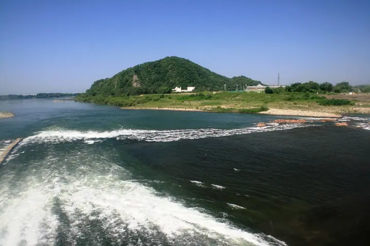
Mt. Igiyama is a 173-meter standalone peak on the right bank of the Kiso River in southeastern Unuma, Kakamigahara City, Gifu Prefecture — nicknamed Yūgure-Fuji ("Sunset Fuji") for its conical form from the east and Neshakayama ("Reclining Buddha") for its profile from another angle. Its summit hosts the ruins of Igiyama Castle, a Sengoku-period stronghold, and the city maintains the Igi-no-Mori satoyama park here with two trekking courses — the ~2 km Zekkei (Scenic) course and ~3 km Onei (Ridge) course. It is also included in the Kakamigahara Tourist Association's Kakamigahara Alps traverse map and is featured in the Furusato Fuji 100 list.
Mt. Igiyama at a glance
- Weather: The most settled day in the next 7 days is Wed, November 4: clear, gusts up to 5 m/s.
Mt. Igiyama weather (hourly, 14 days)
Sunrise today 06:15, sunset 16:57
| Tue, 11/3 | Wed, 11/4 | Thu, 11/5 | Fri, 11/6 | Sat, 11/7 | Sun, 11/8 | Mon, 11/9 | Tue, 11/10 | Wed, 11/11 | Thu, 11/12 | Fri, 11/13 | Sat, 11/14 | Sun, 11/15 | Mon, 11/16 | Tue, 11/17 | |||||||||||||||||||||||||||||||||||||||||||||||||||||||||||||||||||||||
|---|---|---|---|---|---|---|---|---|---|---|---|---|---|---|---|---|---|---|---|---|---|---|---|---|---|---|---|---|---|---|---|---|---|---|---|---|---|---|---|---|---|---|---|---|---|---|---|---|---|---|---|---|---|---|---|---|---|---|---|---|---|---|---|---|---|---|---|---|---|---|---|---|---|---|---|---|---|---|---|---|---|---|---|---|---|
| Japan time | 15 | 17 | 19 | 21 | 23 | 1 | 3 | 5 | 7 | 9 | 11 | 13 | 15 | 18 | 21 | 0 | 3 | 6 | 9 | 12 | 15 | 18 | 21 | 0 | 3 | 6 | 9 | 12 | 15 | 18 | 21 | 0 | 3 | 6 | 9 | 12 | 15 | 18 | 21 | 0 | 3 | 6 | 9 | 12 | 15 | 18 | 21 | 0 | 3 | 6 | 9 | 15 | 21 | 3 | 9 | 15 | 21 | 3 | 9 | 15 | 21 | 3 | 9 | 15 | 21 | 3 | 9 | 15 | 21 | 3 | 9 | 15 | 21 | 3 | 9 | 15 | 21 | 3 | 9 | 15 | 21 | 3 | 9 | 15 | |
  |   | | | | | | |   | |  |   | |   |   | | | |   |   | |  | | | |   | | | | | | | | | | | | | | | | | | | |   | | | | | | |   | | | | | | | | |  | | | | | | | | | | | | | |   | | | | | | | | | ||
| Temperature | °C | 20° | 17° | 14° | 12° | 11° | 9° | 8° | 8° | 8° | 13° | 17° | 18° | 18° | 16° | 14° | 12° | 12° | 13° | 16° | 16° | 18° | 16° | 14° | 14° | 14° | 13° | 18° | 20° | 19° | 15° | 13° | 12° | 10° | 9° | 12° | 14° | 13° | 10° | 8° | 8° | 7° | 7° | 11° | 15° | 15° | 12° | 11° | 10° | 10° | 10° | 11° | 18° | 10° | 6° | 11° | 16° | 11° | 8° | 10° | 14° | 8° | 4° | 9° | 15° | 8° | 7° | 11° | 15° | 8° | 5° | 11° | 15° | 11° | 11° | 13° | 15° | 14° | 14° | 16° | 19° | 11° | 7° | 8° | 12° |
| Precipitation | mm | 0.1 | 0.4 | 7 | 6 | 0.3 | 0.1 | 0.5 | 1.5 | 0.8 | 0.1 | 0.2 | 1.1 | 7 | 8 | ||||||||||||||||||||||||||||||||||||||||||||||||||||||||||||||||||||||
| New snow | cm | ||||||||||||||||||||||||||||||||||||||||||||||||||||||||||||||||||||||||||||||||||||
| Snow depth | cm | 0 | 0 | 0 | 0 | 0 | 0 | 0 | 0 | 0 | 0 | 0 | 0 | 0 | 0 | 0 | 0 | 0 | 0 | 0 | 0 | 0 | 0 | 0 | 0 | 0 | 0 | 0 | 0 | 0 | 0 | 0 | 0 | 0 | 0 | 0 | 0 | 0 | 0 | 0 | 0 | 0 | 0 | 0 | 0 | 0 | 0 | 0 | 0 | 0 | 0 | 0 | 0 | 0 | 0 | 0 | 0 | 0 | 0 | 0 | 0 | 0 | 0 | 0 | 0 | 0 | 0 | 0 | 0 | 0 | 0 | 0 | 0 | 0 | 0 | 0 | 0 | 0 | 0 | 0 | 0 | 0 | 0 | 0 | 0 |
| Wind | m/s | 3 | 4 | 2 | 1 | 2 | 1 | 2 | 1 | 2 | 1 | 1 | 1 | 1 | 1 | 0 | 2 | 2 | 2 | 1 | 1 | 0 | 2 | 1 | 1 | 1 | 1 | 3 | 5 | 6 | 4 | 3 | 4 | 3 | 2 | 4 | 6 | 6 | 5 | 4 | 3 | 4 | 3 | 2 | 3 | 3 | 2 | 1 | 1 | 1 | 1 | 1 | 4 | 1 | 1 | 0 | 1 | 2 | 3 | 4 | 6 | 3 | 1 | 1 | 1 | 1 | 1 | 0 | 4 | 3 | 1 | 1 | 2 | 1 | 1 | 1 | 1 | 2 | 1 | 2 | 6 | 3 | 2 | 2 | 2 |
| Wind gusts | m/s | 7 | 8 | 8 | 4 | 3 | 3 | 3 | 3 | 3 | 3 | 4 | 5 | 4 | 3 | 2 | 7 | 7 | 4 | 4 | 4 | 3 | 3 | 3 | 2 | 2 | 4 | 6 | 11 | 14 | 12 | 8 | 8 | 8 | 6 | 8 | 14 | 13 | 12 | 9 | 7 | 7 | 7 | 6 | 8 | 9 | 7 | 5 | 3 | 2 | 2 | 3 | 9 | 8 | 3 | 3 | 4 | 5 | 10 | 9 | 15 | 12 | 7 | 3 | 5 | 7 | 3 | 4 | 10 | 9 | 5 | 3 | 5 | 4 | 3 | 3 | 3 | 4 | 6 | 5 | 13 | 12 | 7 | 6 | 6 |
| Wind dir. | ↓ | ↓ | ↓ | ↓ | ↓ | ↓ | ↓ | ↓ | ↓ | ↓ | ↓ | ↓ | ↓ | ↓ | ↓ | ↓ | ↓ | ↓ | ↓ | ↓ | ↓ | ↓ | ↓ | ↓ | ↓ | ↓ | ↓ | ↓ | ↓ | ↓ | ↓ | ↓ | ↓ | ↓ | ↓ | ↓ | ↓ | ↓ | ↓ | ↓ | ↓ | ↓ | ↓ | ↓ | ↓ | ↓ | ↓ | ↓ | ↓ | ↓ | ↓ | ↓ | ↓ | ↓ | ↓ | ↓ | ↓ | ↓ | ↓ | ↓ | ↓ | ↓ | ↓ | ↓ | ↓ | ↓ | ↓ | ↓ | ↓ | ↓ | ↓ | ↓ | ↓ | ↓ | ↓ | ↓ | ↓ | ↓ | ↓ | ↓ | ↓ | ↓ | ↓ | ↓ | |
Huts, campsites and lodging near Mt. Igiyama
Campsites
- 伊木山フォレスト
Lodging
- ホテルインディゴ犬山有楽苑
- Inuyama City Hotel
- 犬山セントラルホテル
- 犬山ミヤコホテル
- 犬山館
Lists that include Mt. Igiyama
Mt. Igiyama facts
- Also known as
- 夕暮富士(ゆうぐれふじ) · 寝釈迦山(ねしゃかやま)
- Elevation
- 173 m
- Location
- Kakamigahara, Gifu
35.384349, 136.922538 - Website
- www.city.kakamigahara.lg.jp
- Trail Map
- www.city.kakamigahara.lg.jp (PDF)
- Wikipedia
- ja.wikipedia.org