
Mt. Hatofukiyama
鳩吹山
Kani, Gifu · Elevation 313 m
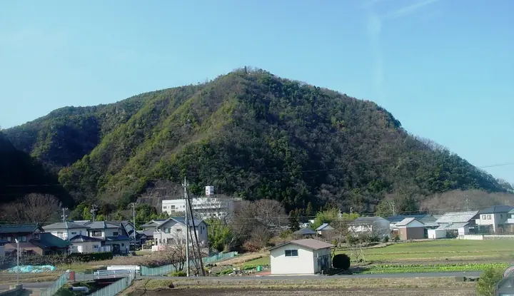
Mt. Hatofukiyama is a 313 m hill in Kani City, Gifu Prefecture, standing within the Hida-Kisogawa Quasi-National Park area. The second-highest summit in the city, it has five trailheads (Ōwaki, Katakuri, Shinzenji, Nishiyama, and Ishihara) maintained by Kani City, with a roughly 30-minute walk leading to a summit that overlooks the Kiso River, Mt. Hakusan, and the Northern Alps. The peak is featured in Aichi 130-zan, Tōkai no Hyakuzan, and Gifu no Yamatabi (Vol. 2).
Mt. Hatofukiyama at a glance
- Weather: The most settled day in the next 7 days is Wed, November 4: clear, gusts up to 5 m/s.
- Route: The shortest is Mount Hatobuki from Shinzenji Trailhead: about 1 h 17 min, 2.1 km, about 200 m of climbing.
Mt. Hatofukiyama weather (hourly, 14 days)
Sunrise today 06:15, sunset 16:57
| Tue, 11/3 | Wed, 11/4 | Thu, 11/5 | Fri, 11/6 | Sat, 11/7 | Sun, 11/8 | Mon, 11/9 | Tue, 11/10 | Wed, 11/11 | Thu, 11/12 | Fri, 11/13 | Sat, 11/14 | Sun, 11/15 | Mon, 11/16 | Tue, 11/17 | |||||||||||||||||||||||||||||||||||||||||||||||||||||||||||||||||||||||
|---|---|---|---|---|---|---|---|---|---|---|---|---|---|---|---|---|---|---|---|---|---|---|---|---|---|---|---|---|---|---|---|---|---|---|---|---|---|---|---|---|---|---|---|---|---|---|---|---|---|---|---|---|---|---|---|---|---|---|---|---|---|---|---|---|---|---|---|---|---|---|---|---|---|---|---|---|---|---|---|---|---|---|---|---|---|
| Japan time | 15 | 17 | 19 | 21 | 23 | 1 | 3 | 5 | 7 | 9 | 11 | 13 | 15 | 18 | 21 | 0 | 3 | 6 | 9 | 12 | 15 | 18 | 21 | 0 | 3 | 6 | 9 | 12 | 15 | 18 | 21 | 0 | 3 | 6 | 9 | 12 | 15 | 18 | 21 | 0 | 3 | 6 | 9 | 12 | 15 | 18 | 21 | 0 | 3 | 6 | 9 | 15 | 21 | 3 | 9 | 15 | 21 | 3 | 9 | 15 | 21 | 3 | 9 | 15 | 21 | 3 | 9 | 15 | 21 | 3 | 9 | 15 | 21 | 3 | 9 | 15 | 21 | 3 | 9 | 15 | 21 | 3 | 9 | 15 | |
 |   | | | | | | |   | | | |   |   |   |   | | |   | | |  | |   | |   | |   | | | | | | | | | | | | | | | | | | | | | | | | |   | | | | | | | | |  | | | | | | | | | | | | | |   | | |   | | | | | | ||
| Temperature | °C | 20° | 15° | 12° | 11° | 9° | 7° | 6° | 6° | 7° | 13° | 17° | 18° | 17° | 15° | 13° | 11° | 12° | 13° | 15° | 16° | 18° | 15° | 13° | 12° | 13° | 12° | 17° | 20° | 19° | 14° | 12° | 11° | 9° | 8° | 12° | 13° | 13° | 9° | 7° | 6° | 6° | 6° | 11° | 16° | 15° | 11° | 10° | 9° | 9° | 9° | 11° | 17° | 8° | 5° | 11° | 15° | 9° | 7° | 10° | 13° | 6° | 2° | 8° | 14° | 6° | 5° | 12° | 15° | 7° | 4° | 12° | 14° | 10° | 10° | 14° | 14° | 13° | 13° | 16° | 19° | 11° | 5° | 8° | 13° |
| Precipitation | mm | 0.1 | 7 | 7 | 1.2 | 0.3 | 0.2 | 4.0 | 2.3 | 0.6 | 0.7 | 0.1 | 0.1 | 0.3 | 7 | 9 | |||||||||||||||||||||||||||||||||||||||||||||||||||||||||||||||||||||
| New snow | cm | ||||||||||||||||||||||||||||||||||||||||||||||||||||||||||||||||||||||||||||||||||||
| Snow depth | cm | 0 | 0 | 0 | 0 | 0 | 0 | 0 | 0 | 0 | 0 | 0 | 0 | 0 | 0 | 0 | 0 | 0 | 0 | 0 | 0 | 0 | 0 | 0 | 0 | 0 | 0 | 0 | 0 | 0 | 0 | 0 | 0 | 0 | 0 | 0 | 0 | 0 | 0 | 0 | 0 | 0 | 0 | 0 | 0 | 0 | 0 | 0 | 0 | 0 | 0 | 0 | 0 | 0 | 0 | 0 | 0 | 0 | 0 | 0 | 0 | 0 | 0 | 0 | 0 | 0 | 0 | 0 | 0 | 0 | 0 | 0 | 0 | 0 | 0 | 0 | 0 | 0 | 0 | 0 | 0 | 0 | 0 | 0 | 0 |
| Wind | m/s | 2 | 3 | 1 | 0 | 1 | 1 | 1 | 1 | 1 | 1 | 1 | 1 | 1 | 0 | 1 | 1 | 2 | 1 | 1 | 1 | 1 | 0 | 1 | 1 | 1 | 1 | 2 | 4 | 6 | 4 | 2 | 3 | 2 | 1 | 4 | 6 | 6 | 4 | 3 | 3 | 3 | 3 | 2 | 3 | 3 | 1 | 1 | 0 | 1 | 0 | 1 | 4 | 1 | 1 | 0 | 1 | 1 | 3 | 3 | 5 | 3 | 1 | 0 | 2 | 1 | 1 | 1 | 4 | 2 | 2 | 0 | 2 | 2 | 2 | 1 | 1 | 2 | 0 | 2 | 6 | 3 | 2 | 1 | 3 |
| Wind gusts | m/s | 5 | 6 | 5 | 2 | 2 | 2 | 3 | 3 | 2 | 4 | 4 | 5 | 5 | 3 | 2 | 7 | 7 | 4 | 4 | 4 | 3 | 3 | 2 | 2 | 5 | 5 | 5 | 9 | 12 | 12 | 7 | 7 | 6 | 4 | 8 | 13 | 12 | 11 | 8 | 5 | 6 | 6 | 6 | 7 | 7 | 6 | 2 | 2 | 2 | 1 | 2 | 8 | 7 | 3 | 4 | 5 | 4 | 8 | 7 | 13 | 10 | 5 | 3 | 6 | 7 | 3 | 4 | 9 | 7 | 4 | 3 | 6 | 4 | 3 | 3 | 4 | 4 | 5 | 4 | 12 | 11 | 6 | 3 | 7 |
| Wind dir. | ↓ | ↓ | ↓ | ↓ | ↓ | ↓ | ↓ | ↓ | ↓ | ↓ | ↓ | ↓ | ↓ | ↓ | ↓ | ↓ | ↓ | ↓ | ↓ | ↓ | ↓ | ↓ | ↓ | ↓ | ↓ | ↓ | ↓ | ↓ | ↓ | ↓ | ↓ | ↓ | ↓ | ↓ | ↓ | ↓ | ↓ | ↓ | ↓ | ↓ | ↓ | ↓ | ↓ | ↓ | ↓ | ↓ | ↓ | ↓ | ↓ | ↓ | ↓ | ↓ | ↓ | ↓ | ↓ | ↓ | ↓ | ↓ | ↓ | ↓ | ↓ | ↓ | ↓ | ↓ | ↓ | ↓ | ↓ | ↓ | ↓ | ↓ | ↓ | ↓ | ↓ | ↓ | ↓ | ↓ | ↓ | ↓ | ↓ | ↓ | ↓ | ↓ | ↓ | ↓ | |
Mt. Hatofukiyama hiking routes
Hiking times are estimates calculated from the terrain.
Huts, campsites and lodging near Mt. Hatofukiyama
Lodging
- ルートイン美濃加茂
- シティホテル美濃加茂
- Inuyama International Youth Hostel
Lists that include Mt. Hatofukiyama
Mt. Hatofukiyama facts
- Elevation
- 313 m
- Location
- Kani, Gifu
35.419049, 136.999029 - National Park
- 飛騨木曽川国定公園
- Website
- www.city.kani.lg.jp
- Trail Map
- www.city.kani.lg.jp (PDF)
- Wikipedia
- ja.wikipedia.org