
Mt. Gomadan
護摩壇山
Totsukawa, Nara / Tanabe, Wakayama · Elevation 1,372 m
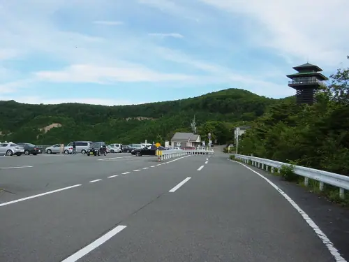
Gomadanzan is a 1,372 m peak straddling the prefectural border between the Ryūjin district of Tanabe City in Wakayama Prefecture and Totsukawa Village in Nara Prefecture, forming the spine of the Kii Mountains and earning it the nickname "the roof of Kishū." Its name comes from a Heike-era legend in which Taira no Koremori, having fled the Battle of Ichinotani, is said to have burned goma fire offerings on this summit to divine the fate of his clan after hearing of the family's defeat at Dan-no-ura. The Kōya-Ryūjin Skyline scenic road reaches near the top, where the Gomasan Skytower observatory and the Gomadanzan Forest Park — with one of Japan's largest rhododendron plantings — give visitors easy access through the surrounding beech forest. The mountain lies within Kōya-Ryūjin Quasi-National Park and is listed in the Japanese 300 Famous Mountains, the Kansai 100, and the Kinki 100.
Mt. Gomadan at a glance
- Weather: The most settled day in the next 7 days is Wed, November 4: cloudy, gusts up to 9 m/s. Fri, Nov 6, Sat, Nov 7: strong wind (gusts up to 19 m/s).
- Route: The shortest is Mount Gomadan, Mount Ryūjin, Mount Mimitori and Sennotoki: about 2 h 22 min, 5.3 km, about 260 m of climbing.
Mt. Gomadan weather (hourly, 14 days)
Sunrise today 06:18, sunset 17:04
| Tue, 11/3 | Wed, 11/4 | Thu, 11/5 | Fri, 11/6 | Sat, 11/7 | Sun, 11/8 | Mon, 11/9 | Tue, 11/10 | Wed, 11/11 | Thu, 11/12 | Fri, 11/13 | Sat, 11/14 | Sun, 11/15 | Mon, 11/16 | Tue, 11/17 | |||||||||||||||||||||||||||||||||||||||||||||||||||||||||||||||||||||||
|---|---|---|---|---|---|---|---|---|---|---|---|---|---|---|---|---|---|---|---|---|---|---|---|---|---|---|---|---|---|---|---|---|---|---|---|---|---|---|---|---|---|---|---|---|---|---|---|---|---|---|---|---|---|---|---|---|---|---|---|---|---|---|---|---|---|---|---|---|---|---|---|---|---|---|---|---|---|---|---|---|---|---|---|---|---|
| Japan time | 15 | 17 | 19 | 21 | 23 | 1 | 3 | 5 | 7 | 9 | 11 | 13 | 15 | 18 | 21 | 0 | 3 | 6 | 9 | 12 | 15 | 18 | 21 | 0 | 3 | 6 | 9 | 12 | 15 | 18 | 21 | 0 | 3 | 6 | 9 | 12 | 15 | 18 | 21 | 0 | 3 | 6 | 9 | 12 | 15 | 18 | 21 | 0 | 3 | 6 | 9 | 15 | 21 | 3 | 9 | 15 | 21 | 3 | 9 | 15 | 21 | 3 | 9 | 15 | 21 | 3 | 9 | 15 | 21 | 3 | 9 | 15 | 21 | 3 | 9 | 15 | 21 | 3 | 9 | 15 | 21 | 3 | 9 | 15 | |
  |  |   | | |   | | | | | |   |   |   | |   | | | |   | | | | | | |   |   | | | |   | | | | | | |  | | | | | | | | | | | | | | |   | | | | | | | |  | | | | | | | | | | | | | | | | | | | | | | | ||
| Temperature | °C | 11° | 8° | 5° | 5° | 5° | 4° | 5° | 4° | 5° | 10° | 14° | 14° | 12° | 9° | 10° | 10° | 10° | 10° | 14° | 14° | 15° | 10° | 10° | 12° | 12° | 10° | 9° | 12° | 10° | 8° | 6° | 4° | 2° | 2° | 4° | 5° | 6° | 3° | 1° | 1° | 1° | 1° | 5° | 8° | 7° | 2° | 2° | 3° | 3° | 4° | 7° | 9° | 3° | 3° | 7° | 8° | 4° | 1° | 2° | 5° | 0° | -1° | 4° | 6° | 1° | 2° | 4° | 6° | 0° | -2° | 8° | 10° | 3° | 4° | 8° | 9° | 10° | 11° | 9° | 10° | 4° | 0° | 3° | 7° |
| Precipitation | mm | 0.1 | 1.3 | 0.5 | 0.1 | 1.6 | 1.4 | 0.6 | 0.2 | 0.2 | 0.2 | 0.6 | 0.4 | 0.5 | 0.5 | 1.0 | 4.9 | 18 | 1.0 | 2.3 | 0.9 | ||||||||||||||||||||||||||||||||||||||||||||||||||||||||||||||||
| New snow | cm | ||||||||||||||||||||||||||||||||||||||||||||||||||||||||||||||||||||||||||||||||||||
| Snow depth | cm | 0 | 0 | 0 | 0 | 0 | 0 | 0 | 0 | 0 | 0 | 0 | 0 | 0 | 0 | 0 | 0 | 0 | 0 | 0 | 0 | 0 | 0 | 0 | 0 | 0 | 0 | 0 | 0 | 0 | 0 | 0 | 0 | 0 | 0 | 0 | 0 | 0 | 0 | 0 | 0 | 0 | 0 | 0 | 0 | 0 | 0 | 0 | 0 | 0 | 0 | 0 | 0 | 0 | 0 | 0 | 0 | 0 | 0 | 0 | 0 | 0 | 0 | 0 | 0 | 0 | 0 | 0 | 0 | 0 | 0 | 0 | 0 | 0 | 0 | 0 | 0 | 0 | 0 | 0 | 0 | 0 | 0 | 0 | 0 |
| Wind | m/s | 3 | 2 | 2 | 2 | 3 | 3 | 3 | 3 | 3 | 2 | 2 | 3 | 2 | 1 | 2 | 1 | 1 | 1 | 2 | 1 | 2 | 1 | 2 | 3 | 4 | 5 | 5 | 6 | 7 | 5 | 6 | 6 | 6 | 5 | 7 | 7 | 7 | 5 | 5 | 5 | 5 | 5 | 5 | 4 | 4 | 3 | 2 | 1 | 1 | 2 | 3 | 4 | 2 | 0 | 1 | 3 | 5 | 7 | 9 | 7 | 6 | 3 | 2 | 3 | 1 | 4 | 5 | 6 | 5 | 2 | 2 | 2 | 1 | 1 | 3 | 3 | 5 | 3 | 5 | 6 | 6 | 3 | 3 | 2 |
| Wind gusts | m/s | 9 | 9 | 7 | 7 | 7 | 7 | 8 | 8 | 8 | 7 | 7 | 9 | 9 | 5 | 8 | 8 | 8 | 5 | 6 | 6 | 6 | 6 | 7 | 10 | 11 | 15 | 15 | 16 | 18 | 17 | 16 | 17 | 17 | 17 | 19 | 19 | 18 | 17 | 14 | 14 | 13 | 14 | 14 | 14 | 12 | 10 | 7 | 4 | 3 | 6 | 9 | 12 | 11 | 4 | 5 | 9 | 13 | 18 | 22 | 23 | 19 | 14 | 8 | 9 | 8 | 11 | 13 | 16 | 16 | 12 | 6 | 8 | 7 | 6 | 10 | 11 | 15 | 15 | 13 | 15 | 15 | 15 | 10 | 9 |
| Wind dir. | ↓ | ↓ | ↓ | ↓ | ↓ | ↓ | ↓ | ↓ | ↓ | ↓ | ↓ | ↓ | ↓ | ↓ | ↓ | ↓ | ↓ | ↓ | ↓ | ↓ | ↓ | ↓ | ↓ | ↓ | ↓ | ↓ | ↓ | ↓ | ↓ | ↓ | ↓ | ↓ | ↓ | ↓ | ↓ | ↓ | ↓ | ↓ | ↓ | ↓ | ↓ | ↓ | ↓ | ↓ | ↓ | ↓ | ↓ | ↓ | ↓ | ↓ | ↓ | ↓ | ↓ | ↓ | ↓ | ↓ | ↓ | ↓ | ↓ | ↓ | ↓ | ↓ | ↓ | ↓ | ↓ | ↓ | ↓ | ↓ | ↓ | ↓ | ↓ | ↓ | ↓ | ↓ | ↓ | ↓ | ↓ | ↓ | ↓ | ↓ | ↓ | ↓ | ↓ | ↓ | |
Mt. Gomadan hiking routes
Hiking times are estimates calculated from the terrain.
Lists that include Mt. Gomadan
Japan's 300 Famous Mountains · Kansai 100 Famous Mountains · Kinki 100 Famous Mountains · Nara 100 Mountains to Explore · Elevations of 1003 Mountains of Japan · 1000 Mountains of Japan
Mt. Gomadan facts
- Elevation
- 1,372 m
- Location
- Totsukawa, Nara / Tanabe, Wakayama
34.057419, 135.567137 - National Park
- 高野龍神国定公園
- Website
- www.ryujin-kanko.jp
- Trail Map
- www.pref.wakayama.lg.jp (PDF)
- Access Information
- www.pref.wakayama.lg.jp
- Wikipedia
- ja.wikipedia.org