
Mt. Bukkasan
仏果山
Aikawa, Kanagawa / Kiyokawa, Kanagawa · Elevation 747 m
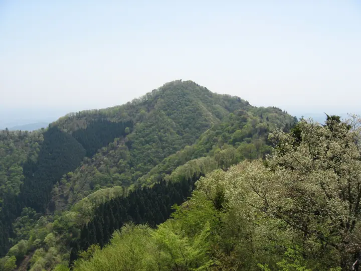
Mount Bukkasan (747 m) rises on the boundary of Aikawa Town and Kiyokawa Village in Kanagawa Prefecture, at the north-eastern edge of Tanzawa-Oyama Quasi-National Park overlooking Lake Miyagase. The shapely cone is known locally as Hambara-Fuji, and a ten-metre observation tower at the summit looks across to the main Tanzawa ridge, central Tokyo and, on clear days, Mount Fuji. The peak forms a popular traverse with Mount Kyō-ga-take and Mount Takatori and is included in the Kanto 100, Japan 100 Sacred Mountains and Furusato Fuji 100 selections.
Mt. Bukkasan at a glance
- Weather: The most settled day in the next 7 days is Fri, November 6: clear, gusts up to 8 m/s.
- Route: The shortest is Mount Bukkasan and Takatoriyama Return from Bukkasan Trailhead: about 4 h 3 min, 6.2 km, about 610 m of climbing.
Mt. Bukkasan weather (hourly, 14 days)
Sunrise today 06:06, sunset 16:47
| Tue, 11/3 | Wed, 11/4 | Thu, 11/5 | Fri, 11/6 | Sat, 11/7 | Sun, 11/8 | Mon, 11/9 | Tue, 11/10 | Wed, 11/11 | Thu, 11/12 | Fri, 11/13 | Sat, 11/14 | Sun, 11/15 | Mon, 11/16 | Tue, 11/17 | |||||||||||||||||||||||||||||||||||||||||||||||||||||||||||||||||||||||
|---|---|---|---|---|---|---|---|---|---|---|---|---|---|---|---|---|---|---|---|---|---|---|---|---|---|---|---|---|---|---|---|---|---|---|---|---|---|---|---|---|---|---|---|---|---|---|---|---|---|---|---|---|---|---|---|---|---|---|---|---|---|---|---|---|---|---|---|---|---|---|---|---|---|---|---|---|---|---|---|---|---|---|---|---|---|
| Japan time | 21 | 23 | 1 | 3 | 5 | 7 | 9 | 11 | 13 | 15 | 17 | 19 | 21 | 0 | 3 | 6 | 9 | 12 | 15 | 18 | 21 | 0 | 3 | 6 | 9 | 12 | 15 | 18 | 21 | 0 | 3 | 6 | 9 | 12 | 15 | 18 | 21 | 0 | 3 | 6 | 9 | 12 | 15 | 18 | 21 | 0 | 3 | 6 | 9 | 12 | 15 | 21 | 3 | 9 | 15 | 21 | 3 | 9 | 15 | 21 | 3 | 9 | 15 | 21 | 3 | 9 | 15 | 21 | 3 | 9 | 15 | 21 | 3 | 9 | 15 | 21 | 3 | 9 | 15 | 21 | 3 | 9 | 15 | 21 | |
  |   | | | |   |   | | | | | | | | | | |   |   |   |   | | | |  | |   | |  | | | | | | | | | | | | | | | | | | | | | | | | | | | | | | |   |  | | | |   | | | | | | | | | | | | |   | | | | | | | ||
| Temperature | °C | 9° | 9° | 8° | 8° | 7° | 7° | 8° | 8° | 8° | 7° | 7° | 7° | 7° | 8° | 8° | 8° | 11° | 13° | 13° | 11° | 9° | 8° | 8° | 8° | 15° | 17° | 16° | 12° | 11° | 9° | 9° | 7° | 10° | 12° | 11° | 7° | 4° | 4° | 5° | 4° | 7° | 9° | 9° | 7° | 6° | 5° | 4° | 4° | 4° | 5° | 5° | 6° | 4° | 6° | 8° | 5° | 4° | 8° | 11° | 3° | 1° | 7° | 8° | 6° | 3° | 9° | 9° | 3° | 2° | 5° | 8° | 4° | 3° | 9° | 12° | 9° | 8° | 13° | 15° | 6° | 5° | 5° | 6° | 4° |
| Precipitation | mm | 1.3 | 0.2 | 0.3 | 0.4 | 0.7 | 1.0 | 1.3 | 3.1 | 6 | 18 | 16 | 8 | 1.3 | 0.2 | 0.4 | 0.1 | 0.3 | 0.2 | 0.3 | 0.5 | 0.8 | 0.1 | 0.2 | 1.2 | 0.3 | 0.1 | 5 | 16 | 0.3 | |||||||||||||||||||||||||||||||||||||||||||||||||||||||
| New snow | cm | ||||||||||||||||||||||||||||||||||||||||||||||||||||||||||||||||||||||||||||||||||||
| Snow depth | cm | 0 | 0 | 0 | 0 | 0 | 0 | 0 | 0 | 0 | 0 | 0 | 0 | 0 | 0 | 0 | 0 | 0 | 0 | 0 | 0 | 0 | 0 | 0 | 0 | 0 | 0 | 0 | 0 | 0 | 0 | 0 | 0 | 0 | 0 | 0 | 0 | 0 | 0 | 0 | 0 | 0 | 0 | 0 | 0 | 0 | 0 | 0 | 0 | 0 | 0 | 0 | 0 | 0 | 0 | 0 | 0 | 0 | 0 | 0 | 0 | 0 | 0 | 0 | 0 | 0 | 0 | 0 | 0 | 0 | 0 | 0 | 0 | 0 | 0 | 0 | 0 | 0 | 0 | 0 | 0 | 0 | 0 | 0 | 0 |
| Wind | m/s | 0 | 1 | 2 | 2 | 1 | 2 | 1 | 2 | 2 | 2 | 2 | 2 | 3 | 2 | 2 | 3 | 3 | 3 | 1 | 0 | 1 | 1 | 1 | 1 | 0 | 2 | 2 | 0 | 1 | 0 | 1 | 0 | 1 | 2 | 2 | 2 | 1 | 0 | 0 | 0 | 1 | 2 | 2 | 1 | 1 | 1 | 2 | 2 | 2 | 1 | 2 | 2 | 2 | 2 | 2 | 0 | 1 | 1 | 4 | 1 | 1 | 1 | 2 | 1 | 2 | 1 | 3 | 0 | 0 | 1 | 2 | 1 | 1 | 1 | 2 | 1 | 1 | 1 | 3 | 1 | 2 | 1 | 2 | 1 |
| Wind gusts | m/s | 2 | 3 | 4 | 4 | 4 | 4 | 4 | 5 | 5 | 5 | 4 | 5 | 5 | 6 | 6 | 7 | 8 | 8 | 7 | 3 | 3 | 4 | 4 | 4 | 5 | 7 | 8 | 6 | 3 | 3 | 3 | 3 | 4 | 7 | 7 | 7 | 4 | 3 | 2 | 2 | 4 | 6 | 5 | 5 | 2 | 3 | 4 | 5 | 5 | 5 | 5 | 5 | 5 | 6 | 7 | 6 | 3 | 7 | 13 | 9 | 4 | 3 | 8 | 5 | 5 | 5 | 9 | 7 | 2 | 4 | 7 | 6 | 3 | 4 | 8 | 6 | 8 | 5 | 7 | 8 | 5 | 5 | 6 | 5 |
| Wind dir. | ↓ | ↓ | ↓ | ↓ | ↓ | ↓ | ↓ | ↓ | ↓ | ↓ | ↓ | ↓ | ↓ | ↓ | ↓ | ↓ | ↓ | ↓ | ↓ | ↓ | ↓ | ↓ | ↓ | ↓ | ↓ | ↓ | ↓ | ↓ | ↓ | ↓ | ↓ | ↓ | ↓ | ↓ | ↓ | ↓ | ↓ | ↓ | ↓ | ↓ | ↓ | ↓ | ↓ | ↓ | ↓ | ↓ | ↓ | ↓ | ↓ | ↓ | ↓ | ↓ | ↓ | ↓ | ↓ | ↓ | ↓ | ↓ | ↓ | ↓ | ↓ | ↓ | ↓ | ↓ | ↓ | ↓ | ↓ | ↓ | ↓ | ↓ | ↓ | ↓ | ↓ | ↓ | ↓ | ↓ | ↓ | ↓ | ↓ | ↓ | ↓ | ↓ | ↓ | ↓ | |
Mt. Bukkasan hiking routes
- Mount Bukkasan and Takatoriyama Return from Bukkasan Trailhead 6.2 km · Ascent 613 m 仏果山登山口 (Bus stop), 仏果山登山口バス停 (Bus stop) (parking)
- Mount Bukkasan–Mount Takatoriyama Loop from Aikawa Fureai-no-Mura 7.0 km · Ascent 660 m 第2駐車場
Hiking times are estimates calculated from the terrain.
Huts, campsites and lodging near Mt. Bukkasan
Campsites
- Chojayashiki Camp Site
- 国際一ノ瀬キャンプ場
- 唐沢キャンプ場
Lodging
- 観泉荘こまや
- 旅館ニュー甲州
- みはる
Mt. Bukkasan facts
- Also known as
- 半原富士
- Elevation
- 747 m
- Location
- Aikawa, Kanagawa / Kiyokawa, Kanagawa
35.520556, 139.258109 - National Park
- 丹沢大山国定公園
- Website
- www.town.aikawa.kanagawa.jp
- Trail Map
- www.town.aikawa.kanagawa.jp (PDF)