
Mt. Bentendake
弁天岳
Kōya-chō, Wakayama · Elevation 985 m
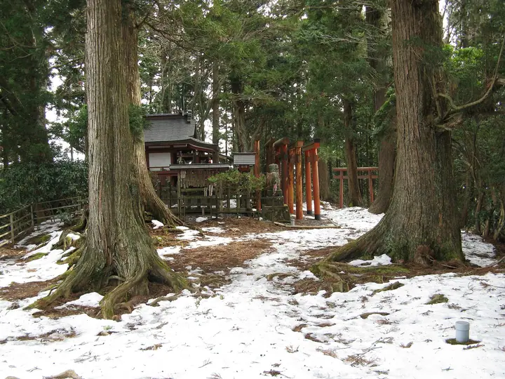
Mt. Bentendake is a 984.5 m peak just north of the Daimon gate of Mt. Kōya in Kōya-cho, Wakayama Prefecture, and is the highest summit in the Kōyasan area. The Nyonin-michi pilgrimage route — used by women in the era of nyonin-kinsei (the ban on women entering the inner sanctuary) — crosses the summit, where a small Benzaiten shrine is enshrined; the route forms part of the Kōya Sankei-michi pilgrimage roads, designated as a National Historic Site and inscribed on the UNESCO World Heritage 'Sacred Sites and Pilgrimage Routes in the Kii Mountain Range'. The peak lies within Kōya-Ryūjin Quasi-National Park.
Mt. Bentendake at a glance
- Weather: The most settled day in the next 7 days is Wed, November 4: clear, gusts up to 8 m/s.
Mt. Bentendake weather (hourly, 14 days)
Sunrise today 06:19, sunset 17:04
| Tue, 11/3 | Wed, 11/4 | Thu, 11/5 | Fri, 11/6 | Sat, 11/7 | Sun, 11/8 | Mon, 11/9 | Tue, 11/10 | Wed, 11/11 | Thu, 11/12 | Fri, 11/13 | Sat, 11/14 | Sun, 11/15 | Mon, 11/16 | Tue, 11/17 | |||||||||||||||||||||||||||||||||||||||||||||||||||||||||||||||||||||||
|---|---|---|---|---|---|---|---|---|---|---|---|---|---|---|---|---|---|---|---|---|---|---|---|---|---|---|---|---|---|---|---|---|---|---|---|---|---|---|---|---|---|---|---|---|---|---|---|---|---|---|---|---|---|---|---|---|---|---|---|---|---|---|---|---|---|---|---|---|---|---|---|---|---|---|---|---|---|---|---|---|---|---|---|---|---|
| Japan time | 15 | 17 | 19 | 21 | 23 | 1 | 3 | 5 | 7 | 9 | 11 | 13 | 15 | 18 | 21 | 0 | 3 | 6 | 9 | 12 | 15 | 18 | 21 | 0 | 3 | 6 | 9 | 12 | 15 | 18 | 21 | 0 | 3 | 6 | 9 | 12 | 15 | 18 | 21 | 0 | 3 | 6 | 9 | 12 | 15 | 18 | 21 | 0 | 3 | 6 | 9 | 15 | 21 | 3 | 9 | 15 | 21 | 3 | 9 | 15 | 21 | 3 | 9 | 15 | 21 | 3 | 9 | 15 | 21 | 3 | 9 | 15 | 21 | 3 | 9 | 15 | 21 | 3 | 9 | 15 | 21 | 3 | 9 | 15 | |
  |   |   | | | | | | | | | | |   |   | | | | |   |   |  | | |   | |   | | | | |   | | | |   | | | | | | | | | | | | |   | |  | | | | | | | | | | |  | | | | | | | | | | | | | | | | | | |   |  | | | ||
| Temperature | °C | 12° | 10° | 8° | 7° | 6° | 6° | 6° | 5° | 6° | 10° | 12° | 14° | 13° | 9° | 9° | 10° | 10° | 10° | 14° | 14° | 16° | 12° | 11° | 12° | 12° | 11° | 11° | 14° | 13° | 10° | 9° | 6° | 5° | 5° | 7° | 7° | 8° | 5° | 2° | 2° | 2° | 2° | 7° | 9° | 9° | 4° | 5° | 5° | 5° | 5° | 9° | 11° | 5° | 3° | 9° | 10° | 6° | 3° | 5° | 7° | 2° | 0° | 6° | 8° | 3° | 2° | 6° | 8° | 2° | 0° | 8° | 12° | 2° | 3° | 11° | 13° | 11° | 11° | 11° | 12° | 6° | 1° | 5° | 8° |
| Precipitation | mm | 1.1 | 0.2 | 1.1 | 0.8 | 0.7 | 0.4 | 0.3 | 0.2 | 1.4 | 0.3 | 0.1 | 0.3 | 2.7 | 16 | 1.5 | 2.9 | 0.4 | |||||||||||||||||||||||||||||||||||||||||||||||||||||||||||||||||||
| New snow | cm | ||||||||||||||||||||||||||||||||||||||||||||||||||||||||||||||||||||||||||||||||||||
| Snow depth | cm | 0 | 0 | 0 | 0 | 0 | 0 | 0 | 0 | 0 | 0 | 0 | 0 | 0 | 0 | 0 | 0 | 0 | 0 | 0 | 0 | 0 | 0 | 0 | 0 | 0 | 0 | 0 | 0 | 0 | 0 | 0 | 0 | 0 | 0 | 0 | 0 | 0 | 0 | 0 | 0 | 0 | 0 | 0 | 0 | 0 | 0 | 0 | 0 | 0 | 0 | 0 | 0 | 0 | 0 | 0 | 0 | 0 | 0 | 0 | 0 | 0 | 0 | 0 | 0 | 0 | 0 | 0 | 0 | 0 | 0 | 0 | 0 | 0 | 0 | 0 | 0 | 0 | 0 | 0 | 0 | 0 | 0 | 0 | 0 |
| Wind | m/s | 3 | 1 | 1 | 2 | 2 | 2 | 3 | 3 | 3 | 3 | 2 | 3 | 2 | 1 | 2 | 0 | 1 | 2 | 1 | 1 | 2 | 0 | 2 | 3 | 3 | 3 | 3 | 4 | 5 | 2 | 3 | 4 | 3 | 3 | 5 | 4 | 5 | 3 | 1 | 1 | 1 | 2 | 3 | 3 | 3 | 2 | 2 | 1 | 1 | 1 | 1 | 3 | 1 | 1 | 2 | 3 | 3 | 4 | 5 | 5 | 2 | 1 | 1 | 2 | 0 | 2 | 4 | 4 | 2 | 2 | 0 | 2 | 1 | 2 | 2 | 3 | 2 | 2 | 3 | 4 | 3 | 1 | 2 | 2 |
| Wind gusts | m/s | 8 | 7 | 4 | 5 | 6 | 6 | 7 | 7 | 8 | 8 | 8 | 7 | 8 | 5 | 4 | 4 | 5 | 4 | 4 | 5 | 5 | 5 | 5 | 8 | 11 | 9 | 9 | 11 | 13 | 12 | 8 | 10 | 10 | 8 | 12 | 13 | 12 | 12 | 8 | 5 | 4 | 5 | 8 | 10 | 9 | 9 | 5 | 4 | 2 | 2 | 4 | 8 | 7 | 3 | 6 | 9 | 9 | 10 | 12 | 15 | 14 | 5 | 4 | 7 | 6 | 6 | 9 | 12 | 11 | 5 | 6 | 6 | 5 | 5 | 6 | 8 | 10 | 9 | 7 | 12 | 11 | 9 | 6 | 8 |
| Wind dir. | ↓ | ↓ | ↓ | ↓ | ↓ | ↓ | ↓ | ↓ | ↓ | ↓ | ↓ | ↓ | ↓ | ↓ | ↓ | ↓ | ↓ | ↓ | ↓ | ↓ | ↓ | ↓ | ↓ | ↓ | ↓ | ↓ | ↓ | ↓ | ↓ | ↓ | ↓ | ↓ | ↓ | ↓ | ↓ | ↓ | ↓ | ↓ | ↓ | ↓ | ↓ | ↓ | ↓ | ↓ | ↓ | ↓ | ↓ | ↓ | ↓ | ↓ | ↓ | ↓ | ↓ | ↓ | ↓ | ↓ | ↓ | ↓ | ↓ | ↓ | ↓ | ↓ | ↓ | ↓ | ↓ | ↓ | ↓ | ↓ | ↓ | ↓ | ↓ | ↓ | ↓ | ↓ | ↓ | ↓ | ↓ | ↓ | ↓ | ↓ | ↓ | ↓ | ↓ | ↓ | |
Huts, campsites and lodging near Mt. Bentendake
Lodging
- Saizen-in
- Guest House Suzumeno Kakurembo
- Fukuchi-in
- Jokiin
- Muryoko-in
Mt. Bentendake facts
- Elevation
- 985 m
- Location
- Kōya-chō, Wakayama
34.220466, 135.572410 - National Park
- 高野龍神国定公園
- Website
- www.pref.wakayama.lg.jp
- Trail Map
- www.pref.wakayama.lg.jp (PDF)