
Mt. Awa
粟ヶ岳
Kakegawa, Shizuoka · Elevation 532 m
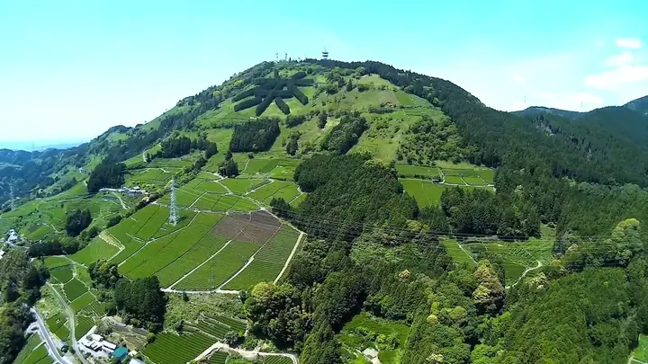
Mt. Awa is a 532 m peak straddling the boundary between the Higashiyama area of Kakegawa City and Shimada City in Shizuoka Prefecture — the southern terminus of the Akaishi Range and a symbol of Kakegawa. The southeastern slope below the summit holds the giant "茶" (tea) character formed by planted hinoki cypresses since 1932, visible from Shimada and the Makinohara Plateau. The summit hosts the "Awagatake World Agricultural Heritage Chagusaba Terrace" ("Kapposhi Terrace"), overlooking the Chagusaba tea-grass farming landscape recognized by FAO as a Globally Important Agricultural Heritage System in 2013. The summit is reached in about 1–1.5 hours from the Higashiyama Ippukudokoro pavilion. The peak is included on the Shizuoka 100 Mountains list.
Mt. Awa at a glance
- Weather: The most settled day in the next 7 days is Mon, November 9: clear, gusts up to 7 m/s. Sat, Nov 7: strong wind (gusts up to 15 m/s).
Mt. Awa weather (hourly, 14 days)
Sunrise today 06:10, sunset 16:53
| Tue, 11/3 | Wed, 11/4 | Thu, 11/5 | Fri, 11/6 | Sat, 11/7 | Sun, 11/8 | Mon, 11/9 | Tue, 11/10 | Wed, 11/11 | Thu, 11/12 | Fri, 11/13 | Sat, 11/14 | Sun, 11/15 | Mon, 11/16 | Tue, 11/17 | |||||||||||||||||||||||||||||||||||||||||||||||||||||||||||||||||||||||
|---|---|---|---|---|---|---|---|---|---|---|---|---|---|---|---|---|---|---|---|---|---|---|---|---|---|---|---|---|---|---|---|---|---|---|---|---|---|---|---|---|---|---|---|---|---|---|---|---|---|---|---|---|---|---|---|---|---|---|---|---|---|---|---|---|---|---|---|---|---|---|---|---|---|---|---|---|---|---|---|---|---|---|---|---|---|
| Japan time | 15 | 17 | 19 | 21 | 23 | 1 | 3 | 5 | 7 | 9 | 11 | 13 | 15 | 18 | 21 | 0 | 3 | 6 | 9 | 12 | 15 | 18 | 21 | 0 | 3 | 6 | 9 | 12 | 15 | 18 | 21 | 0 | 3 | 6 | 9 | 12 | 15 | 18 | 21 | 0 | 3 | 6 | 9 | 12 | 15 | 18 | 21 | 0 | 3 | 6 | 9 | 15 | 21 | 3 | 9 | 15 | 21 | 3 | 9 | 15 | 21 | 3 | 9 | 15 | 21 | 3 | 9 | 15 | 21 | 3 | 9 | 15 | 21 | 3 | 9 | 15 | 21 | 3 | 9 | 15 | 21 | 3 | 9 | 15 | |
  |   |   | | | |   | |   | | | |   |   | | | | | |   | | | |   | | |  | | |  | | | | | |   | | | | | | | | | |   | | | | | | | |   | |   | | | | | | | | | | | | | |  | | | | | | | | | | | | | | | ||
| Temperature | °C | 16° | 13° | 12° | 11° | 11° | 11° | 11° | 13° | 12° | 13° | 14° | 15° | 14° | 12° | 12° | 12° | 13° | 14° | 16° | 19° | 16° | 14° | 14° | 13° | 12° | 13° | 18° | 21° | 19° | 15° | 13° | 12° | 10° | 9° | 11° | 15° | 14° | 10° | 7° | 5° | 4° | 4° | 13° | 15° | 14° | 10° | 9° | 9° | 8° | 8° | 12° | 16° | 10° | 8° | 12° | 14° | 8° | 8° | 10° | 14° | 5° | 6° | 11° | 12° | 5° | 7° | 12° | 15° | 9° | 7° | 10° | 13° | 6° | 10° | 14° | 13° | 12° | 13° | 16° | 20° | 11° | 12° | 11° | 12° |
| Precipitation | mm | 0.3 | 0.3 | 0.6 | 3.1 | 2.6 | 9 | 2.6 | 2.6 | 0.5 | 3.3 | 0.2 | 0.2 | 0.2 | 0.2 | 0.4 | 3.2 | 30 | 20 | 14 | |||||||||||||||||||||||||||||||||||||||||||||||||||||||||||||||||
| New snow | cm | ||||||||||||||||||||||||||||||||||||||||||||||||||||||||||||||||||||||||||||||||||||
| Snow depth | cm | 0 | 0 | 0 | 0 | 0 | 0 | 0 | 0 | 0 | 0 | 0 | 0 | 0 | 0 | 0 | 0 | 0 | 0 | 0 | 0 | 0 | 0 | 0 | 0 | 0 | 0 | 0 | 0 | 0 | 0 | 0 | 0 | 0 | 0 | 0 | 0 | 0 | 0 | 0 | 0 | 0 | 0 | 0 | 0 | 0 | 0 | 0 | 0 | 0 | 0 | 0 | 0 | 0 | 0 | 0 | 0 | 0 | 0 | 0 | 0 | 0 | 0 | 0 | 0 | 0 | 0 | 0 | 0 | 0 | 0 | 0 | 0 | 0 | 0 | 0 | 0 | 0 | 0 | 0 | 0 | 0 | 0 | 0 | 0 |
| Wind | m/s | 2 | 1 | 1 | 2 | 2 | 3 | 3 | 4 | 4 | 4 | 3 | 5 | 4 | 6 | 7 | 7 | 6 | 3 | 1 | 2 | 1 | 1 | 2 | 2 | 3 | 4 | 4 | 6 | 7 | 7 | 7 | 7 | 6 | 6 | 6 | 7 | 6 | 5 | 3 | 2 | 1 | 2 | 2 | 1 | 3 | 1 | 1 | 1 | 1 | 2 | 0 | 2 | 3 | 3 | 2 | 3 | 3 | 8 | 5 | 0 | 2 | 1 | 1 | 1 | 1 | 5 | 2 | 2 | 2 | 1 | 2 | 1 | 1 | 0 | 2 | 1 | 1 | 0 | 4 | 6 | 4 | 4 | 3 | 2 |
| Wind gusts | m/s | 7 | 6 | 3 | 3 | 4 | 5 | 5 | 7 | 8 | 9 | 9 | 10 | 11 | 13 | 15 | 16 | 14 | 11 | 6 | 5 | 6 | 4 | 3 | 4 | 6 | 9 | 12 | 14 | 15 | 15 | 16 | 15 | 15 | 14 | 14 | 15 | 15 | 13 | 11 | 7 | 3 | 3 | 6 | 6 | 7 | 7 | 3 | 3 | 3 | 4 | 4 | 7 | 8 | 6 | 6 | 8 | 7 | 17 | 18 | 11 | 5 | 4 | 4 | 5 | 3 | 10 | 10 | 7 | 6 | 5 | 4 | 5 | 4 | 2 | 6 | 7 | 6 | 7 | 8 | 14 | 13 | 11 | 8 | 9 |
| Wind dir. | ↓ | ↓ | ↓ | ↓ | ↓ | ↓ | ↓ | ↓ | ↓ | ↓ | ↓ | ↓ | ↓ | ↓ | ↓ | ↓ | ↓ | ↓ | ↓ | ↓ | ↓ | ↓ | ↓ | ↓ | ↓ | ↓ | ↓ | ↓ | ↓ | ↓ | ↓ | ↓ | ↓ | ↓ | ↓ | ↓ | ↓ | ↓ | ↓ | ↓ | ↓ | ↓ | ↓ | ↓ | ↓ | ↓ | ↓ | ↓ | ↓ | ↓ | ↓ | ↓ | ↓ | ↓ | ↓ | ↓ | ↓ | ↓ | ↓ | ↓ | ↓ | ↓ | ↓ | ↓ | ↓ | ↓ | ↓ | ↓ | ↓ | ↓ | ↓ | ↓ | ↓ | ↓ | ↓ | ↓ | ↓ | ↓ | ↓ | ↓ | ↓ | ↓ | ↓ | ↓ | |
Huts, campsites and lodging near Mt. Awa
Mountain huts
- 掛川市広域避難所:倉真小学校
- 掛川市広域避難所:日坂小学校
- 島田市第一次指定避難所
Lodging
- 落合荘
- 真砂館
- 旅館 翠月
- 旅ノ舎
- ヴィラルラーシュ
Lists that include Mt. Awa
Mt. Awa facts
- Also known as
- あわんたけ
- Elevation
- 532 m
- Location
- Kakegawa, Shizuoka
34.841444, 138.067331 - Website
- www.kakegawa-kankou.com
- Trail Map
- www.city.kakegawa.shizuoka.jp (PDF)
- Access Information
- www.kakegawa-kankou.com
- Wikipedia
- ja.wikipedia.org