
Mt. Arima-Fuji
有馬富士
Sanda, Hyogo · Elevation 374 m
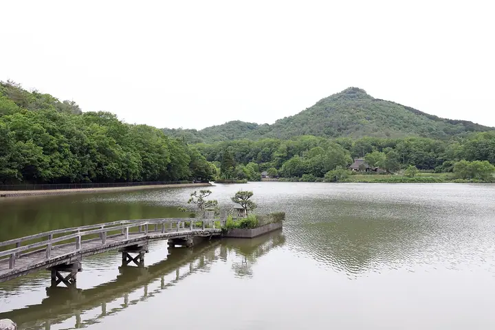
Mt. Arima-Fuji (374 m), also called Tsuno-yama, rises in Sanda City, Hyōgo Prefecture, and is included in the Furusato Hyōgo 100, Hyōgo Yama-Kei guide and Japan's 100 Fujis lists. Its symmetrical conical profile earned the affectionate nickname "Arima Fuji," and the peak serves as the symbol of Sanda City. The mountain and adjacent Fukushima-Ōike Pond were developed in 1989 as Hyōgo Prefectural Arima-Fuji Park — the largest urban park in the prefecture, totalling 416 hectares — incorporating the Kippī-yama Nature Learning Center and the Sā-fu-no-Mori municipal forest park.
Mt. Arima-Fuji at a glance
- Weather: The most settled day in the next 7 days is Thu, November 5: clear, gusts up to 5 m/s.
- Route: The shortest is Arima Fuji Park Loop via Wanpaku Fort to the Summit and the Hydrangea Path: about 1 h 51 min, 4.6 km, about 210 m of climbing.
Mt. Arima-Fuji weather (hourly, 14 days)
Sunrise today 06:21, sunset 17:04
| Tue, 11/3 | Wed, 11/4 | Thu, 11/5 | Fri, 11/6 | Sat, 11/7 | Sun, 11/8 | Mon, 11/9 | Tue, 11/10 | Wed, 11/11 | Thu, 11/12 | Fri, 11/13 | Sat, 11/14 | Sun, 11/15 | Mon, 11/16 | Tue, 11/17 | |||||||||||||||||||||||||||||||||||||||||||||||||||||||||||||||||||||||
|---|---|---|---|---|---|---|---|---|---|---|---|---|---|---|---|---|---|---|---|---|---|---|---|---|---|---|---|---|---|---|---|---|---|---|---|---|---|---|---|---|---|---|---|---|---|---|---|---|---|---|---|---|---|---|---|---|---|---|---|---|---|---|---|---|---|---|---|---|---|---|---|---|---|---|---|---|---|---|---|---|---|---|---|---|---|
| Japan time | 21 | 23 | 1 | 3 | 5 | 7 | 9 | 11 | 13 | 15 | 17 | 19 | 21 | 0 | 3 | 6 | 9 | 12 | 15 | 18 | 21 | 0 | 3 | 6 | 9 | 12 | 15 | 18 | 21 | 0 | 3 | 6 | 9 | 12 | 15 | 18 | 21 | 0 | 3 | 6 | 9 | 12 | 15 | 18 | 21 | 0 | 3 | 6 | 9 | 12 | 15 | 21 | 3 | 9 | 15 | 21 | 3 | 9 | 15 | 21 | 3 | 9 | 15 | 21 | 3 | 9 | 15 | 21 | 3 | 9 | 15 | 21 | 3 | 9 | 15 | 21 | 3 | 9 | 15 | 21 | 3 | 9 | 15 | 21 | |
  |  | | |   |   | |   | | | |   | |   | | |   | | |   |   | | | | |   | | |  | | | | | | | | | | | | | | | | | | | | |   | | |   |  | | | | | | |  | | | | | | | | | | | | | | | | |   | | | | | |  | ||
| Temperature | °C | 10° | 10° | 10° | 10° | 10° | 10° | 13° | 16° | 15° | 16° | 14° | 13° | 14° | 13° | 13° | 13° | 15° | 20° | 20° | 16° | 15° | 16° | 13° | 12° | 14° | 18° | 17° | 12° | 10° | 8° | 7° | 5° | 11° | 12° | 11° | 8° | 6° | 6° | 7° | 6° | 10° | 11° | 11° | 8° | 9° | 8° | 8° | 8° | 12° | 16° | 15° | 8° | 6° | 10° | 14° | 7° | 7° | 10° | 11° | 6° | 4° | 10° | 12° | 7° | 6° | 11° | 11° | 6° | 5° | 10° | 14° | 8° | 8° | 13° | 15° | 13° | 13° | 15° | 14° | 9° | 5° | 9° | 11° | 6° |
| Precipitation | mm | 0.4 | 1.3 | 1.8 | 0.2 | 0.1 | 0.4 | 0.3 | 0.7 | 0.9 | 0.3 | 0.2 | 0.1 | 0.3 | 2.7 | 2.6 | 0.2 | 1.0 | 0.2 | ||||||||||||||||||||||||||||||||||||||||||||||||||||||||||||||||||
| New snow | cm | ||||||||||||||||||||||||||||||||||||||||||||||||||||||||||||||||||||||||||||||||||||
| Snow depth | cm | 0 | 0 | 0 | 0 | 0 | 0 | 0 | 0 | 0 | 0 | 0 | 0 | 0 | 0 | 0 | 0 | 0 | 0 | 0 | 0 | 0 | 0 | 0 | 0 | 0 | 0 | 0 | 0 | 0 | 0 | 0 | 0 | 0 | 0 | 0 | 0 | 0 | 0 | 0 | 0 | 0 | 0 | 0 | 0 | 0 | 0 | 0 | 0 | 0 | 0 | 0 | 0 | 0 | 0 | 0 | 0 | 0 | 0 | 0 | 0 | 0 | 0 | 0 | 0 | 0 | 0 | 0 | 0 | 0 | 0 | 0 | 0 | 0 | 0 | 0 | 0 | 0 | 0 | 0 | 0 | 0 | 0 | 0 | 0 |
| Wind | m/s | 3 | 4 | 3 | 4 | 4 | 3 | 4 | 3 | 3 | 3 | 3 | 3 | 4 | 5 | 3 | 2 | 0 | 0 | 2 | 1 | 3 | 5 | 4 | 1 | 2 | 4 | 4 | 3 | 2 | 2 | 2 | 1 | 5 | 6 | 6 | 4 | 2 | 3 | 4 | 3 | 5 | 5 | 5 | 3 | 3 | 2 | 2 | 1 | 1 | 4 | 4 | 2 | 1 | 2 | 4 | 3 | 5 | 6 | 6 | 2 | 1 | 1 | 2 | 1 | 1 | 6 | 5 | 3 | 2 | 1 | 2 | 2 | 2 | 2 | 3 | 2 | 2 | 4 | 7 | 6 | 3 | 5 | 3 | 2 |
| Wind gusts | m/s | 7 | 7 | 7 | 7 | 8 | 8 | 10 | 9 | 8 | 8 | 6 | 5 | 8 | 9 | 9 | 6 | 5 | 3 | 5 | 6 | 5 | 11 | 11 | 8 | 6 | 9 | 9 | 9 | 7 | 5 | 5 | 5 | 11 | 13 | 13 | 13 | 8 | 6 | 8 | 8 | 10 | 12 | 12 | 11 | 7 | 5 | 4 | 3 | 4 | 10 | 10 | 8 | 3 | 6 | 11 | 8 | 12 | 13 | 15 | 13 | 5 | 4 | 6 | 5 | 3 | 12 | 13 | 12 | 6 | 5 | 6 | 5 | 4 | 6 | 8 | 8 | 6 | 10 | 15 | 15 | 13 | 10 | 11 | 8 |
| Wind dir. | ↓ | ↓ | ↓ | ↓ | ↓ | ↓ | ↓ | ↓ | ↓ | ↓ | ↓ | ↓ | ↓ | ↓ | ↓ | ↓ | ↓ | ↓ | ↓ | ↓ | ↓ | ↓ | ↓ | ↓ | ↓ | ↓ | ↓ | ↓ | ↓ | ↓ | ↓ | ↓ | ↓ | ↓ | ↓ | ↓ | ↓ | ↓ | ↓ | ↓ | ↓ | ↓ | ↓ | ↓ | ↓ | ↓ | ↓ | ↓ | ↓ | ↓ | ↓ | ↓ | ↓ | ↓ | ↓ | ↓ | ↓ | ↓ | ↓ | ↓ | ↓ | ↓ | ↓ | ↓ | ↓ | ↓ | ↓ | ↓ | ↓ | ↓ | ↓ | ↓ | ↓ | ↓ | ↓ | ↓ | ↓ | ↓ | ↓ | ↓ | ↓ | ↓ | ↓ | ↓ | |
Mt. Arima-Fuji hiking routes
Hiking times are estimates calculated from the terrain.
Huts, campsites and lodging near Mt. Arima-Fuji
Lodging
- Melxe
- Sanda hotel
- SANDA SUMMIT HOTEL
Lists that include Mt. Arima-Fuji
Mt. Arima-Fuji facts
- Also known as
- 角山
- Elevation
- 374 m
- Location
- Sanda, Hyogo
34.924021, 135.230514 - Website
- www.hyogo-park.or.jp
- Wikipedia
- ja.wikipedia.org