
Mount Takatori
高取山
Aikawa, Kanagawa · Elevation 705 m
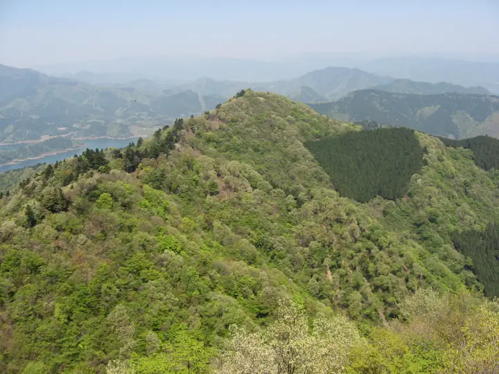
A 10 m observation tower on the summit offers panoramic views. A route climbing from the prefectural Aikawa Fureai no Mura and descending to the right bank of Miyagase Dam takes about three hours and 15 minutes. The final stairs down toward the dam are steep.
Mount Takatori at a glance
- Weather: The most settled day in the next 7 days is Fri, November 6: clear, gusts up to 7 m/s.
- Route: The shortest is Mount Bukkasan and Takatoriyama Return from Bukkasan Trailhead: about 4 h 3 min, 6.2 km, about 610 m of climbing.
Mount Takatori weather (hourly, 14 days)
Sunrise today 06:06, sunset 16:47
| Tue, 11/3 | Wed, 11/4 | Thu, 11/5 | Fri, 11/6 | Sat, 11/7 | Sun, 11/8 | Mon, 11/9 | Tue, 11/10 | Wed, 11/11 | Thu, 11/12 | Fri, 11/13 | Sat, 11/14 | Sun, 11/15 | Mon, 11/16 | Tue, 11/17 | |||||||||||||||||||||||||||||||||||||||||||||||||||||||||||||||||||||||
|---|---|---|---|---|---|---|---|---|---|---|---|---|---|---|---|---|---|---|---|---|---|---|---|---|---|---|---|---|---|---|---|---|---|---|---|---|---|---|---|---|---|---|---|---|---|---|---|---|---|---|---|---|---|---|---|---|---|---|---|---|---|---|---|---|---|---|---|---|---|---|---|---|---|---|---|---|---|---|---|---|---|---|---|---|---|
| Japan time | 15 | 17 | 19 | 21 | 23 | 1 | 3 | 5 | 7 | 9 | 11 | 13 | 15 | 18 | 21 | 0 | 3 | 6 | 9 | 12 | 15 | 18 | 21 | 0 | 3 | 6 | 9 | 12 | 15 | 18 | 21 | 0 | 3 | 6 | 9 | 12 | 15 | 18 | 21 | 0 | 3 | 6 | 9 | 12 | 15 | 18 | 21 | 0 | 3 | 6 | 9 | 15 | 21 | 3 | 9 | 15 | 21 | 3 | 9 | 15 | 21 | 3 | 9 | 15 | 21 | 3 | 9 | 15 | 21 | 3 | 9 | 15 | 21 | 3 | 9 | 15 | 21 | 3 | 9 | 15 | 21 | 3 | 9 | 15 | |
  |   | | | |   | | |   | | | | | | | | | | |   |   |   |   |   | | |  | | |  | | | | | | | | | | | | | | | | | | | | | | | | | | | | | | |   |  | | | |   | | | | | | | | | | | | |   | | | | | | ||
| Temperature | °C | 13° | 11° | 10° | 9° | 9° | 9° | 8° | 8° | 8° | 8° | 9° | 9° | 8° | 8° | 7° | 8° | 8° | 9° | 11° | 15° | 15° | 12° | 10° | 9° | 9° | 9° | 14° | 18° | 17° | 12° | 11° | 11° | 9° | 7° | 10° | 12° | 11° | 8° | 6° | 6° | 5° | 5° | 8° | 10° | 10° | 8° | 7° | 7° | 6° | 6° | 6° | 8° | 6° | 5° | 6° | 8° | 5° | 5° | 8° | 11° | 3° | 1° | 7° | 9° | 6° | 4° | 9° | 9° | 3° | 2° | 5° | 8° | 4° | 3° | 9° | 13° | 9° | 8° | 14° | 16° | 7° | 5° | 5° | 7° |
| Precipitation | mm | 0.1 | 1.3 | 0.5 | 0.4 | 0.1 | 0.3 | 0.7 | 1.5 | 5 | 12 | 19 | 15 | 3.0 | 1.0 | 1.4 | 0.1 | 1.2 | 0.3 | 0.1 | 5 | 16 | 0.3 | ||||||||||||||||||||||||||||||||||||||||||||||||||||||||||||||
| New snow | cm | ||||||||||||||||||||||||||||||||||||||||||||||||||||||||||||||||||||||||||||||||||||
| Snow depth | cm | 0 | 0 | 0 | 0 | 0 | 0 | 0 | 0 | 0 | 0 | 0 | 0 | 0 | 0 | 0 | 0 | 0 | 0 | 0 | 0 | 0 | 0 | 0 | 0 | 0 | 0 | 0 | 0 | 0 | 0 | 0 | 0 | 0 | 0 | 0 | 0 | 0 | 0 | 0 | 0 | 0 | 0 | 0 | 0 | 0 | 0 | 0 | 0 | 0 | 0 | 0 | 0 | 0 | 0 | 0 | 0 | 0 | 0 | 0 | 0 | 0 | 0 | 0 | 0 | 0 | 0 | 0 | 0 | 0 | 0 | 0 | 0 | 0 | 0 | 0 | 0 | 0 | 0 | 0 | 0 | 0 | 0 | 0 | 0 |
| Wind | m/s | 1 | 1 | 1 | 1 | 1 | 1 | 1 | 1 | 1 | 1 | 2 | 2 | 1 | 2 | 2 | 2 | 2 | 3 | 3 | 2 | 1 | 1 | 1 | 1 | 1 | 1 | 1 | 2 | 2 | 1 | 1 | 1 | 1 | 0 | 1 | 3 | 2 | 2 | 0 | 0 | 1 | 0 | 1 | 1 | 2 | 0 | 1 | 1 | 1 | 1 | 2 | 2 | 2 | 2 | 2 | 2 | 0 | 1 | 1 | 4 | 1 | 1 | 1 | 2 | 1 | 2 | 1 | 3 | 0 | 0 | 1 | 2 | 1 | 1 | 1 | 2 | 1 | 1 | 1 | 3 | 1 | 2 | 1 | 2 |
| Wind gusts | m/s | 5 | 4 | 2 | 3 | 3 | 3 | 3 | 3 | 3 | 4 | 5 | 5 | 5 | 5 | 5 | 5 | 6 | 7 | 7 | 9 | 7 | 3 | 3 | 3 | 4 | 4 | 3 | 6 | 7 | 6 | 3 | 3 | 3 | 3 | 5 | 7 | 7 | 6 | 4 | 2 | 2 | 2 | 4 | 6 | 6 | 5 | 2 | 2 | 4 | 4 | 4 | 7 | 5 | 5 | 6 | 7 | 6 | 3 | 7 | 13 | 9 | 4 | 3 | 8 | 5 | 5 | 5 | 9 | 7 | 2 | 4 | 7 | 6 | 3 | 4 | 8 | 6 | 8 | 5 | 7 | 8 | 5 | 5 | 6 |
| Wind dir. | ↓ | ↓ | ↓ | ↓ | ↓ | ↓ | ↓ | ↓ | ↓ | ↓ | ↓ | ↓ | ↓ | ↓ | ↓ | ↓ | ↓ | ↓ | ↓ | ↓ | ↓ | ↓ | ↓ | ↓ | ↓ | ↓ | ↓ | ↓ | ↓ | ↓ | ↓ | ↓ | ↓ | ↓ | ↓ | ↓ | ↓ | ↓ | ↓ | ↓ | ↓ | ↓ | ↓ | ↓ | ↓ | ↓ | ↓ | ↓ | ↓ | ↓ | ↓ | ↓ | ↓ | ↓ | ↓ | ↓ | ↓ | ↓ | ↓ | ↓ | ↓ | ↓ | ↓ | ↓ | ↓ | ↓ | ↓ | ↓ | ↓ | ↓ | ↓ | ↓ | ↓ | ↓ | ↓ | ↓ | ↓ | ↓ | ↓ | ↓ | ↓ | ↓ | ↓ | ||
Mount Takatori hiking routes
- Mount Bukkasan and Takatoriyama Return from Bukkasan Trailhead 6.2 km · Ascent 613 m 仏果山登山口 (Bus stop), 仏果山登山口バス停 (Bus stop) (parking)
- Mount Bukkasan–Mount Takatoriyama Loop from Aikawa Fureai-no-Mura 7.0 km · Ascent 660 m 第2駐車場
Hiking times are estimates calculated from the terrain.
Huts, campsites and lodging near Mount Takatori
Campsites
- Chojayashiki Camp Site
- 国際一ノ瀬キャンプ場
- 唐沢キャンプ場
Lodging
- みはる
- 観泉荘こまや
- 旅館ニュー甲州
Mount Takatori facts
- Elevation
- 705 m
- Location
- Aikawa, Kanagawa
35.526202, 139.250363 - Website
- www.town.aikawa.kanagawa.jp
- Trail Map
- www.town.aikawa.kanagawa.jp
- Wikipedia
- ja.wikipedia.org