
Mount Shiro
小仏城山
Sagamihara, Kanagawa / Hachiōji-shi, Tokyo · Elevation 670 m
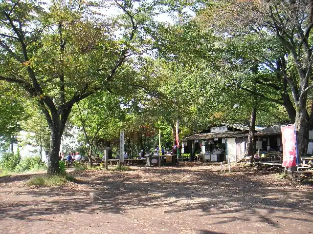
Mount Shiro, also called Kobotoke-Shiroyama, is a 670.3 m peak on the border between Hachioji City in Tokyo and Midori Ward of Sagamihara in Kanagawa, immediately adjacent to Mount Takao on the Oku-Takao traverse ridge. The summit, named for a Sengoku-period Hojo fortress raised against the Takeda, offers a grassy clearing and tea house with views taking in both Michelin three-star Mount Takao and World Heritage Mount Fuji. The Tokai Nature Trail and Kanto Fureai Trail run across the peak, which lies within Meiji-no-Mori Takao Quasi-National Park.
Mount Shiro at a glance
- Weather: The most settled day in the next 7 days is Wed, November 4: cloudy, gusts up to 4 m/s.
- Route: The shortest is Kobotoke to Mount Takao via Kobotoke-shiroyama: about 3 h 44 min, 7.3 km, about 550 m of climbing.
Mount Shiro weather (hourly, 14 days)
Sunrise today 06:06, sunset 16:47
| Tue, 11/3 | Wed, 11/4 | Thu, 11/5 | Fri, 11/6 | Sat, 11/7 | Sun, 11/8 | Mon, 11/9 | Tue, 11/10 | Wed, 11/11 | Thu, 11/12 | Fri, 11/13 | Sat, 11/14 | Sun, 11/15 | Mon, 11/16 | Tue, 11/17 | |||||||||||||||||||||||||||||||||||||||||||||||||||||||||||||||||||||||
|---|---|---|---|---|---|---|---|---|---|---|---|---|---|---|---|---|---|---|---|---|---|---|---|---|---|---|---|---|---|---|---|---|---|---|---|---|---|---|---|---|---|---|---|---|---|---|---|---|---|---|---|---|---|---|---|---|---|---|---|---|---|---|---|---|---|---|---|---|---|---|---|---|---|---|---|---|---|---|---|---|---|---|---|---|---|
| Japan time | 15 | 17 | 19 | 21 | 23 | 1 | 3 | 5 | 7 | 9 | 11 | 13 | 15 | 18 | 21 | 0 | 3 | 6 | 9 | 12 | 15 | 18 | 21 | 0 | 3 | 6 | 9 | 12 | 15 | 18 | 21 | 0 | 3 | 6 | 9 | 12 | 15 | 18 | 21 | 0 | 3 | 6 | 9 | 12 | 15 | 18 | 21 | 0 | 3 | 6 | 9 | 15 | 21 | 3 | 9 | 15 | 21 | 3 | 9 | 15 | 21 | 3 | 9 | 15 | 21 | 3 | 9 | 15 | 21 | 3 | 9 | 15 | 21 | 3 | 9 | 15 | 21 | 3 | 9 | 15 | 21 | 3 | 9 | 15 | |
  |   |   | | | | | |   | | |   | | | | | | | |   |   |   |   | | | |  | | |  | | | | | | | |   | | | | | | | | | | | | | | | | | | | | | | |   |  | | | | | | | | | | | | | | | |   | | | | | | | ||
| Temperature | °C | 14° | 13° | 12° | 11° | 10° | 10° | 9° | 9° | 9° | 10° | 11° | 11° | 10° | 9° | 9° | 9° | 10° | 10° | 12° | 17° | 15° | 13° | 11° | 10° | 9° | 8° | 15° | 19° | 18° | 13° | 11° | 11° | 10° | 8° | 11° | 13° | 13° | 9° | 7° | 7° | 6° | 5° | 10° | 12° | 12° | 10° | 9° | 8° | 7° | 7° | 8° | 9° | 8° | 6° | 8° | 10° | 7° | 4° | 10° | 12° | 3° | 0° | 8° | 10° | 8° | 4° | 11° | 11° | 4° | 2° | 6° | 9° | 3° | 3° | 9° | 13° | 9° | 9° | 14° | 18° | 8° | 6° | 6° | 8° |
| Precipitation | mm | 1.2 | 0.9 | 0.3 | 0.2 | 0.3 | 0.9 | 3.3 | 9 | 16 | 14 | 4.3 | 0.1 | 2.4 | 0.7 | 0.2 | 0.8 | 0.2 | 2.8 | 12 | |||||||||||||||||||||||||||||||||||||||||||||||||||||||||||||||||
| New snow | cm | ||||||||||||||||||||||||||||||||||||||||||||||||||||||||||||||||||||||||||||||||||||
| Snow depth | cm | 0 | 0 | 0 | 0 | 0 | 0 | 0 | 0 | 0 | 0 | 0 | 0 | 0 | 0 | 0 | 0 | 0 | 0 | 0 | 0 | 0 | 0 | 0 | 0 | 0 | 0 | 0 | 0 | 0 | 0 | 0 | 0 | 0 | 0 | 0 | 0 | 0 | 0 | 0 | 0 | 0 | 0 | 0 | 0 | 0 | 0 | 0 | 0 | 0 | 0 | 0 | 0 | 0 | 0 | 0 | 0 | 0 | 0 | 0 | 0 | 0 | 0 | 0 | 0 | 0 | 0 | 0 | 0 | 0 | 0 | 0 | 0 | 0 | 0 | 0 | 0 | 0 | 0 | 0 | 0 | 0 | 0 | 0 | 0 |
| Wind | m/s | 1 | 0 | 0 | 1 | 1 | 1 | 0 | 0 | 0 | 0 | 1 | 1 | 1 | 1 | 2 | 1 | 2 | 1 | 2 | 1 | 1 | 1 | 0 | 1 | 2 | 2 | 0 | 2 | 2 | 1 | 1 | 0 | 1 | 0 | 2 | 3 | 2 | 2 | 0 | 0 | 0 | 0 | 1 | 2 | 2 | 0 | 1 | 1 | 1 | 1 | 1 | 1 | 1 | 2 | 1 | 2 | 0 | 1 | 2 | 4 | 1 | 1 | 1 | 1 | 1 | 2 | 1 | 4 | 0 | 0 | 1 | 2 | 1 | 1 | 1 | 1 | 1 | 0 | 0 | 4 | 1 | 2 | 1 | 2 |
| Wind gusts | m/s | 5 | 4 | 2 | 1 | 2 | 2 | 2 | 2 | 2 | 3 | 4 | 4 | 4 | 3 | 4 | 3 | 4 | 5 | 6 | 6 | 5 | 3 | 2 | 3 | 4 | 4 | 4 | 6 | 7 | 6 | 2 | 2 | 3 | 2 | 5 | 8 | 8 | 7 | 5 | 2 | 2 | 2 | 5 | 7 | 6 | 5 | 3 | 3 | 3 | 2 | 4 | 7 | 4 | 4 | 5 | 6 | 5 | 3 | 6 | 13 | 9 | 4 | 3 | 8 | 4 | 4 | 5 | 11 | 9 | 2 | 4 | 7 | 6 | 3 | 4 | 7 | 4 | 5 | 4 | 9 | 9 | 5 | 5 | 6 |
| Wind dir. | ↓ | ↓ | ↓ | ↓ | ↓ | ↓ | ↓ | ↓ | ↓ | ↓ | ↓ | ↓ | ↓ | ↓ | ↓ | ↓ | ↓ | ↓ | ↓ | ↓ | ↓ | ↓ | ↓ | ↓ | ↓ | ↓ | ↓ | ↓ | ↓ | ↓ | ↓ | ↓ | ↓ | ↓ | ↓ | ↓ | ↓ | ↓ | ↓ | ↓ | ↓ | ↓ | ↓ | ↓ | ↓ | ↓ | ↓ | ↓ | ↓ | ↓ | ↓ | ↓ | ↓ | ↓ | ↓ | ↓ | ↓ | ↓ | ↓ | ↓ | ↓ | ↓ | ↓ | ↓ | ↓ | ↓ | ↓ | ↓ | ↓ | ↓ | ↓ | ↓ | ↓ | ↓ | ↓ | ↓ | ↓ | ↓ | ↓ | ↓ | ↓ | ↓ | ↓ | ||
Mount Shiro hiking routes
- Kobotoke to Mount Takao via Kobotoke-shiroyama 7.3 km · Ascent 548 m 小仏 (Bus stop) → Takaosan (Station), Sancho (Aerialway station)
- Mount Takao and Kobotoke-Shiroyama Traverse 9.5 km · Ascent 651 m Takaosanguchi (Station), 高尾山口駅 (Bus stop) (parking) → 小仏 (Bus stop)
- Lake Sagami to Mount Takao via Kobotoke-shiroyama 11.8 km · Ascent 747 m 相模湖駅 (Bus stop), Sagamiko (Station), 桂北小学校前 (Bus stop) (parking) → Takaosanguchi (Station), 高尾山口駅 (Bus stop) (parking)
- Kagenobuyama–Kobotoke-Shiroyama–Mount Takao Traverse 10.9 km · Ascent 731 m 小仏 (Bus stop) → Takaosanguchi (Station), 高尾山口駅 (Bus stop) (parking)
- Mount Takao to Kobotoke Shiroyama and Sagamiko Station Traverse 11.4 km · Ascent 746 m Takaosanguchi (Station), 高尾山口駅 (Bus stop) (parking) → 相模湖駅 (Bus stop), Sagamiko (Station), 桂北小学校前 (Bus stop) (parking)
- Mount Takao–Mount Kagenobu Traverse via the Inariyama Course 10.7 km · Ascent 831 m Takaosanguchi (Station), 高尾山口駅 (Bus stop) (parking) → 小仏 (Bus stop)
- Mount Takao–Kobotoke Shiroyama Circuit via the Inariyama and No. 3 Trails 11.4 km · Ascent 786 m 稲荷山コース登山口, Kiyotaki (Station), 清滝駅 (Aerialway station), Sanroku (Aerialway station)
- Mount Takao and Kobotoke Shiroyama via Inariyama Trail 11.3 km · Ascent 797 m 稲荷山コース登山口, Kiyotaki (Station), 清滝駅 (Aerialway station), Sanroku (Aerialway station)
- Mount Takao and Mount Kobotoke Shiroyama from the Inariyama Course to Takao Station 14.0 km · Ascent 784 m 稲荷山コース登山口, Kiyotaki (Station), 清滝駅 (Aerialway station), Sanroku (Aerialway station) → 高尾駅北口 (Bus station), 高尾駅北口 (Bus stop), Takao (Station), 高尾駅西 (Bus stop), 高尾駅入口 (Bus stop)
- Kanto Fureai Trail Tokyo Route 1: Lake Trail 16.1 km · Ascent 954 m 梅の木平バス停 (Bus stop) (parking) → Takaosanguchi (Station), 高尾山口駅 (Bus stop) (parking)
- Okutakao Ridge Traverse from Jinba Kogen-shita to Mount Takao 15.5 km · Ascent 1,030 m 陣馬高原下 (Bus stop) (parking) → Takaosan (Station), Sancho (Aerialway station)
- Mount Takao to Mount Jinba Traverse: Kanto Fureai Bird Trail 19.4 km · Ascent 1,169 m Takaosanguchi (Station), 高尾山口駅 (Bus stop) (parking) → 下案下 (Bus stop), くぬぎ沢橋 (Bus stop)
- Mount Takao to Mount Jinba Traverse via Kobotoke Shiroyama and Kagenobu 17.7 km · Ascent 1,164 m Takaosanguchi (Station), 高尾山口駅 (Bus stop) (parking) → 陣馬高原下 (Bus stop) (parking)
- Jinba Trailhead to Takaosanguchi Station via Mount Jinba, Mount Kagenobu, Kobotoke Shiroyama and Mount Takao 19.4 km · Ascent 1,196 m 陣馬登山口 (Bus stop) → Takaosanguchi (Station), 高尾山口駅 (Bus stop) (parking)
Hiking times are estimates calculated from the terrain.
Huts, campsites and lodging near Mount Shiro
Campsites
- Hikagesawa Campsite
- PICAさがみ湖
- みの石滝 キャンプ場
- 相模湖休養村キャンプ場
Lodging
- かぐや
- 桂月
- Shimizutei
- Flower Villa Sagamiko
- Mt.TAKAO BASE CAMP hostel
Lists that include Mount Shiro
Mount Shiro facts
- Also known as
- 城山 · 小仏城山・南小仏山・毛無山・南峠・ジョウ山
- Elevation
- 670 m
- Location
- Sagamihara, Kanagawa / Hachiōji-shi, Tokyo
35.629871, 139.221169 - National Park
- 明治の森高尾国定公園
- Website
- www.city.hachioji.tokyo.jp
- Trail Map
- www.city.hachioji.tokyo.jp (PDF)
- Wikipedia
- ja.wikipedia.org