
Mount Shakujō
尺丈山
Hitachiōmiya-shi, Ibaraki · Elevation 511 m
A 511.5-meter peak at the meeting point of Hitachiōmiya City and Daigo Town (Ibaraki) with Nakagawa Town (Tochigi), the highest summit in Hitachiōmiya, set on the Torinoko sub-massif at the southern end of the Yamizo Range. The small Shakujō-san Jinja shrine crowns the top, and a rest hut with a viewing deck just below commands clear-day views from Mt. Fuji to the Nikkō range and the Pacific Ocean. The 1-to-9-station path is well maintained, and a forest road reaches an eighth-station parking and toilet block, making the summit accessible for casual hikers and families. Listed in the Tochigi 150 Mountains and the Kantō-Area Day-Hike 60.
Mount Shakujō at a glance
- Weather: The most settled day in the next 7 days is Wed, November 4: clear, gusts up to 8 m/s.
Mount Shakujō weather (hourly, 14 days)
Sunrise today 06:04, sunset 16:41
| Tue, 11/3 | Wed, 11/4 | Thu, 11/5 | Fri, 11/6 | Sat, 11/7 | Sun, 11/8 | Mon, 11/9 | Tue, 11/10 | Wed, 11/11 | Thu, 11/12 | Fri, 11/13 | Sat, 11/14 | Sun, 11/15 | Mon, 11/16 | Tue, 11/17 | |||||||||||||||||||||||||||||||||||||||||||||||||||||||||||||||||||||||
|---|---|---|---|---|---|---|---|---|---|---|---|---|---|---|---|---|---|---|---|---|---|---|---|---|---|---|---|---|---|---|---|---|---|---|---|---|---|---|---|---|---|---|---|---|---|---|---|---|---|---|---|---|---|---|---|---|---|---|---|---|---|---|---|---|---|---|---|---|---|---|---|---|---|---|---|---|---|---|---|---|---|---|---|---|---|
| Japan time | 15 | 17 | 19 | 21 | 23 | 1 | 3 | 5 | 7 | 9 | 11 | 13 | 15 | 18 | 21 | 0 | 3 | 6 | 9 | 12 | 15 | 18 | 21 | 0 | 3 | 6 | 9 | 12 | 15 | 18 | 21 | 0 | 3 | 6 | 9 | 12 | 15 | 18 | 21 | 0 | 3 | 6 | 9 | 12 | 15 | 18 | 21 | 0 | 3 | 6 | 9 | 15 | 21 | 3 | 9 | 15 | 21 | 3 | 9 | 15 | 21 | 3 | 9 | 15 | 21 | 3 | 9 | 15 | 21 | 3 | 9 | 15 | 21 | 3 | 9 | 15 | 21 | 3 | 9 | 15 | 21 | 3 | 9 | 15 | |
  |   |   |  | | |   | |  | |   | |   | | |   | | |   | | |   | | | | | | | | | | | | | | | | | | | | | | | | | | | | | | | |   |   | |   | | | | |  | | | | | | | | | | | | | | | | | | | | | | | ||
| Temperature | °C | 14° | 11° | 10° | 8° | 7° | 8° | 7° | 6° | 6° | 12° | 14° | 14° | 12° | 11° | 10° | 9° | 9° | 9° | 11° | 12° | 13° | 12° | 10° | 9° | 9° | 9° | 15° | 20° | 19° | 15° | 13° | 11° | 10° | 9° | 11° | 12° | 10° | 8° | 7° | 6° | 6° | 6° | 9° | 12° | 10° | 7° | 6° | 6° | 6° | 7° | 7° | 11° | 7° | 6° | 9° | 10° | 3° | 3° | 8° | 10° | 5° | 2° | 9° | 12° | 4° | 5° | 11° | 9° | 3° | 1° | 6° | 10° | 4° | 3° | 10° | 13° | 10° | 10° | 13° | 16° | 8° | 4° | 7° | 10° |
| Precipitation | mm | 2.3 | 7 | 9 | 15 | 4.8 | 1.2 | 0.6 | 0.2 | 1.9 | 4.1 | 15 | |||||||||||||||||||||||||||||||||||||||||||||||||||||||||||||||||||||||||
| New snow | cm | ||||||||||||||||||||||||||||||||||||||||||||||||||||||||||||||||||||||||||||||||||||
| Snow depth | cm | 0 | 0 | 0 | 0 | 0 | 0 | 0 | 0 | 0 | 0 | 0 | 0 | 0 | 0 | 0 | 0 | 0 | 0 | 0 | 0 | 0 | 0 | 0 | 0 | 0 | 0 | 0 | 0 | 0 | 0 | 0 | 0 | 0 | 0 | 0 | 0 | 0 | 0 | 0 | 0 | 0 | 0 | 0 | 0 | 0 | 0 | 0 | 0 | 0 | 0 | 0 | 0 | 0 | 0 | 0 | 0 | 0 | 0 | 0 | 0 | 0 | 0 | 0 | 0 | 0 | 0 | 0 | 0 | 0 | 0 | 0 | 0 | 0 | 0 | 0 | 0 | 0 | 0 | 0 | 0 | 0 | 0 | 0 | 0 |
| Wind | m/s | 4 | 4 | 3 | 3 | 2 | 1 | 1 | 2 | 2 | 0 | 1 | 2 | 3 | 0 | 2 | 2 | 3 | 3 | 4 | 5 | 3 | 1 | 2 | 1 | 1 | 1 | 1 | 2 | 4 | 5 | 4 | 6 | 5 | 5 | 6 | 6 | 6 | 5 | 7 | 7 | 6 | 5 | 6 | 5 | 5 | 3 | 3 | 1 | 2 | 3 | 2 | 1 | 3 | 2 | 2 | 3 | 1 | 3 | 5 | 7 | 1 | 2 | 2 | 2 | 2 | 1 | 3 | 5 | 1 | 2 | 1 | 2 | 0 | 1 | 1 | 3 | 1 | 0 | 1 | 6 | 3 | 4 | 1 | 3 |
| Wind gusts | m/s | 11 | 9 | 7 | 7 | 5 | 4 | 2 | 3 | 3 | 3 | 4 | 6 | 8 | 6 | 3 | 4 | 5 | 7 | 10 | 10 | 10 | 7 | 4 | 3 | 3 | 3 | 4 | 6 | 10 | 10 | 10 | 12 | 12 | 12 | 13 | 14 | 15 | 14 | 14 | 15 | 14 | 13 | 14 | 14 | 13 | 10 | 5 | 5 | 5 | 6 | 6 | 5 | 5 | 7 | 5 | 7 | 7 | 4 | 11 | 17 | 16 | 4 | 5 | 6 | 5 | 3 | 8 | 12 | 10 | 6 | 5 | 6 | 6 | 1 | 3 | 9 | 8 | 3 | 4 | 16 | 16 | 9 | 8 | 7 |
| Wind dir. | ↓ | ↓ | ↓ | ↓ | ↓ | ↓ | ↓ | ↓ | ↓ | ↓ | ↓ | ↓ | ↓ | ↓ | ↓ | ↓ | ↓ | ↓ | ↓ | ↓ | ↓ | ↓ | ↓ | ↓ | ↓ | ↓ | ↓ | ↓ | ↓ | ↓ | ↓ | ↓ | ↓ | ↓ | ↓ | ↓ | ↓ | ↓ | ↓ | ↓ | ↓ | ↓ | ↓ | ↓ | ↓ | ↓ | ↓ | ↓ | ↓ | ↓ | ↓ | ↓ | ↓ | ↓ | ↓ | ↓ | ↓ | ↓ | ↓ | ↓ | ↓ | ↓ | ↓ | ↓ | ↓ | ↓ | ↓ | ↓ | ↓ | ↓ | ↓ | ↓ | ↓ | ↓ | ↓ | ↓ | ↓ | ↓ | ↓ | ↓ | ↓ | ↓ | ↓ | ↓ | |
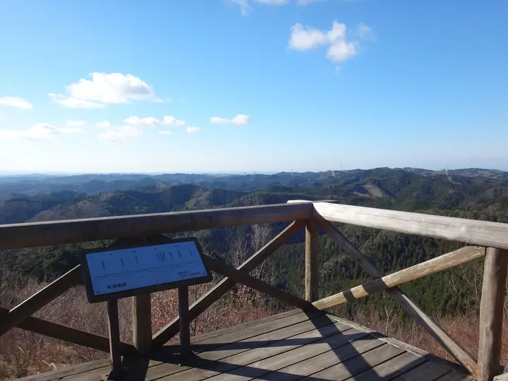
Mount Shakujō facts
- Also known as
- しゃくじょうやま
- Elevation
- 511 m
- Location
- Hitachiōmiya-shi, Ibaraki
36.712601, 140.292497 - Website
- www.city.hitachiomiya.lg.jp
- Trail Map
- www.city.hitachiomiya.lg.jp (PDF)
- Wikipedia
- ja.wikipedia.org