
Mount Seta
世田山
Imabari, Ehime · Elevation 339 m
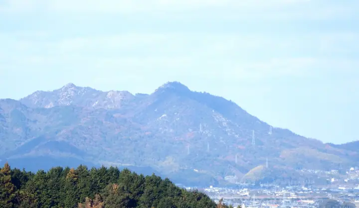
Mount Seta is a 339 m peak on the border of Imabari and Saijo cities in Ehime Prefecture, the highest point of Imabari City. A medieval mountain fortress recorded in the Taiheiki as a major Nanboku-cho period battlefield, it holds the tomb of Otachi Ujimyo, guardian of Iyo Province, at its eighth station. A trail links the summit with Mount Kasamatsu 1.5 km to the northwest from Seta Yakushi Temple in Saijo, and the whole area lies within Setonaikai National Park. Entry restrictions imposed after the 2025 forest fire were lifted on April 14 that year.
Mount Seta at a glance
- Weather: The most settled day in the next 7 days is Thu, November 5: clear, gusts up to 6 m/s.
Mount Seta weather (hourly, 14 days)
Sunrise today 06:28, sunset 17:15
| Tue, 11/3 | Wed, 11/4 | Thu, 11/5 | Fri, 11/6 | Sat, 11/7 | Sun, 11/8 | Mon, 11/9 | Tue, 11/10 | Wed, 11/11 | Thu, 11/12 | Fri, 11/13 | Sat, 11/14 | Sun, 11/15 | Mon, 11/16 | Tue, 11/17 | |||||||||||||||||||||||||||||||||||||||||||||||||||||||||||||||||||||||
|---|---|---|---|---|---|---|---|---|---|---|---|---|---|---|---|---|---|---|---|---|---|---|---|---|---|---|---|---|---|---|---|---|---|---|---|---|---|---|---|---|---|---|---|---|---|---|---|---|---|---|---|---|---|---|---|---|---|---|---|---|---|---|---|---|---|---|---|---|---|---|---|---|---|---|---|---|---|---|---|---|---|---|---|---|---|
| Japan time | 15 | 17 | 19 | 21 | 23 | 1 | 3 | 5 | 7 | 9 | 11 | 13 | 15 | 18 | 21 | 0 | 3 | 6 | 9 | 12 | 15 | 18 | 21 | 0 | 3 | 6 | 9 | 12 | 15 | 18 | 21 | 0 | 3 | 6 | 9 | 12 | 15 | 18 | 21 | 0 | 3 | 6 | 9 | 12 | 15 | 18 | 21 | 0 | 3 | 6 | 9 | 15 | 21 | 3 | 9 | 15 | 21 | 3 | 9 | 15 | 21 | 3 | 9 | 15 | 21 | 3 | 9 | 15 | 21 | 3 | 9 | 15 | 21 | 3 | 9 | 15 | 21 | 3 | 9 | 15 | 21 | 3 | 9 | 15 | |
  | |   | |   | | | |   |   | | | |   | | | | |   | |   |   | | |   | |  | | |  | | | | | | | | | | | | | | | | | | | | | | |   | | | | | | | | | | | | | |   | | | | | | | | | | | | | | | | | | ||
| Temperature | °C | 17° | 14° | 13° | 12° | 12° | 12° | 12° | 12° | 11° | 13° | 14° | 15° | 15° | 12° | 12° | 13° | 12° | 12° | 13° | 16° | 17° | 15° | 15° | 16° | 15° | 13° | 16° | 18° | 17° | 13° | 10° | 9° | 9° | 8° | 10° | 12° | 13° | 10° | 8° | 8° | 7° | 8° | 11° | 12° | 12° | 10° | 10° | 10° | 11° | 11° | 13° | 15° | 11° | 5° | 12° | 14° | 9° | 8° | 9° | 12° | 8° | 7° | 10° | 13° | 8° | 8° | 11° | 13° | 10° | 6° | 10° | 12° | 9° | 8° | 13° | 14° | 12° | 13° | 15° | 18° | 11° | 9° | 9° | 11° |
| Precipitation | mm | 0.1 | 0.4 | 0.8 | 0.7 | 0.2 | 1.3 | 1.9 | 2.0 | 0.3 | 0.5 | 1.3 | 0.9 | 0.6 | 0.7 | 0.2 | 0.1 | 0.5 | 1.3 | 7 | 0.7 | 0.6 | 0.2 | 2.2 | 0.3 | ||||||||||||||||||||||||||||||||||||||||||||||||||||||||||||
| New snow | cm | ||||||||||||||||||||||||||||||||||||||||||||||||||||||||||||||||||||||||||||||||||||
| Snow depth | cm | 0 | 0 | 0 | 0 | 0 | 0 | 0 | 0 | 0 | 0 | 0 | 0 | 0 | 0 | 0 | 0 | 0 | 0 | 0 | 0 | 0 | 0 | 0 | 0 | 0 | 0 | 0 | 0 | 0 | 0 | 0 | 0 | 0 | 0 | 0 | 0 | 0 | 0 | 0 | 0 | 0 | 0 | 0 | 0 | 0 | 0 | 0 | 0 | 0 | 0 | 0 | 0 | 0 | 0 | 0 | 0 | 0 | 0 | 0 | 0 | 0 | 0 | 0 | 0 | 0 | 0 | 0 | 0 | 0 | 0 | 0 | 0 | 0 | 0 | 0 | 0 | 0 | 0 | 0 | 0 | 0 | 0 | 0 | 0 |
| Wind | m/s | 1 | 1 | 2 | 0 | 1 | 1 | 2 | 3 | 3 | 3 | 3 | 3 | 2 | 1 | 1 | 0 | 0 | 0 | 0 | 2 | 1 | 1 | 1 | 2 | 1 | 1 | 2 | 4 | 5 | 3 | 2 | 1 | 2 | 2 | 3 | 2 | 1 | 2 | 1 | 1 | 1 | 1 | 3 | 3 | 2 | 1 | 1 | 1 | 0 | 0 | 2 | 1 | 0 | 1 | 2 | 4 | 2 | 4 | 2 | 1 | 1 | 0 | 1 | 1 | 2 | 1 | 1 | 3 | 3 | 2 | 2 | 1 | 1 | 1 | 1 | 1 | 1 | 2 | 1 | 3 | 4 | 3 | 3 | 1 |
| Wind gusts | m/s | 5 | 4 | 5 | 5 | 4 | 4 | 5 | 6 | 7 | 8 | 9 | 9 | 8 | 7 | 3 | 4 | 2 | 3 | 3 | 5 | 6 | 4 | 4 | 7 | 8 | 4 | 6 | 11 | 12 | 11 | 8 | 6 | 6 | 6 | 8 | 9 | 7 | 5 | 6 | 4 | 3 | 4 | 7 | 8 | 8 | 6 | 3 | 3 | 3 | 2 | 6 | 7 | 5 | 3 | 5 | 9 | 10 | 10 | 10 | 8 | 6 | 4 | 4 | 6 | 5 | 4 | 5 | 9 | 9 | 8 | 6 | 6 | 5 | 3 | 4 | 5 | 5 | 6 | 5 | 8 | 11 | 10 | 7 | 8 |
| Wind dir. | ↓ | ↓ | ↓ | ↓ | ↓ | ↓ | ↓ | ↓ | ↓ | ↓ | ↓ | ↓ | ↓ | ↓ | ↓ | ↓ | ↓ | ↓ | ↓ | ↓ | ↓ | ↓ | ↓ | ↓ | ↓ | ↓ | ↓ | ↓ | ↓ | ↓ | ↓ | ↓ | ↓ | ↓ | ↓ | ↓ | ↓ | ↓ | ↓ | ↓ | ↓ | ↓ | ↓ | ↓ | ↓ | ↓ | ↓ | ↓ | ↓ | ↓ | ↓ | ↓ | ↓ | ↓ | ↓ | ↓ | ↓ | ↓ | ↓ | ↓ | ↓ | ↓ | ↓ | ↓ | ↓ | ↓ | ↓ | ↓ | ↓ | ↓ | ↓ | ↓ | ↓ | ↓ | ↓ | ↓ | ↓ | ↓ | ↓ | ↓ | ↓ | ↓ | ↓ | ↓ | |
Huts, campsites and lodging near Mount Seta
Campsites
- Kyukamura Setouchitoyo Seaside Camping Ground
- Sakuraikaihinfureaihiro Camping Ground
Lodging
- 休暇村瀬戸内東予
- ホテル アジュール 汐の丸
Mount Seta facts
- Elevation
- 339 m
- Location
- Imabari, Ehime
33.977642, 133.041349 - National Park
- 瀬戸内海国立公園
- Website
- www.city.imabari.ehime.jp
- Wikipedia
- ja.wikipedia.org