
Mount Sekidō
石動山
Nakanoto, Ishikawa · Elevation 564 m
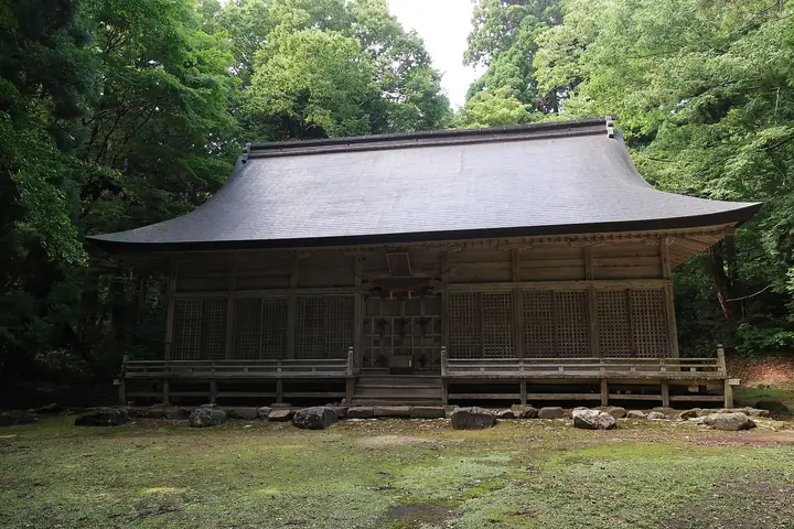
Mount Sekidō is a 564 m peak straddling Ishikawa and Toyama prefectures, with its summit in Nakanoto Town in Ishikawa's Kashima District where it serves as the town's highest point; the peak is also known by its older reading Isurugi-yama. Said to have been opened by the priest Taichō in the Nara period, it became the cultic centre of mountain worship across the three provinces of Kaga, Noto and Etchū, with the Tenpyō-ji temple complex at its top holding more than 360 sub-temples and some 3,000 monks at its medieval peak and roughly 80 affiliate temples across the Hokuriku and Tōhoku regions. Largely abandoned in the Meiji era, the site is now a National Historic Site featuring the reconstructed Daiguya-bō, surviving Kyūkan-bō and one of Noto's largest natural beech forests, and is maintained as the Noto Historical Park's Sekidō-zan area. The annual yama-biraki rite is held at Isurugihiko-jinja on 7 July.
Mount Sekidō at a glance
- Weather: The most settled day in the next 7 days is Sun, November 8: cloudy, gusts up to 7 m/s. Fri, Nov 6: strong wind (gusts up to 18 m/s).
Mount Sekidō weather (hourly, 14 days)
Sunrise today 06:17, sunset 16:54
| Tue, 11/3 | Wed, 11/4 | Thu, 11/5 | Fri, 11/6 | Sat, 11/7 | Sun, 11/8 | Mon, 11/9 | Tue, 11/10 | Wed, 11/11 | Thu, 11/12 | Fri, 11/13 | Sat, 11/14 | Sun, 11/15 | Mon, 11/16 | Tue, 11/17 | |||||||||||||||||||||||||||||||||||||||||||||||||||||||||||||||||||||||
|---|---|---|---|---|---|---|---|---|---|---|---|---|---|---|---|---|---|---|---|---|---|---|---|---|---|---|---|---|---|---|---|---|---|---|---|---|---|---|---|---|---|---|---|---|---|---|---|---|---|---|---|---|---|---|---|---|---|---|---|---|---|---|---|---|---|---|---|---|---|---|---|---|---|---|---|---|---|---|---|---|---|---|---|---|---|
| Japan time | 15 | 17 | 19 | 21 | 23 | 1 | 3 | 5 | 7 | 9 | 11 | 13 | 15 | 18 | 21 | 0 | 3 | 6 | 9 | 12 | 15 | 18 | 21 | 0 | 3 | 6 | 9 | 12 | 15 | 18 | 21 | 0 | 3 | 6 | 9 | 12 | 15 | 18 | 21 | 0 | 3 | 6 | 9 | 12 | 15 | 18 | 21 | 0 | 3 | 6 | 9 | 15 | 21 | 3 | 9 | 15 | 21 | 3 | 9 | 15 | 21 | 3 | 9 | 15 | 21 | 3 | 9 | 15 | 21 | 3 | 9 | 15 | 21 | 3 | 9 | 15 | 21 | 3 | 9 | 15 | 21 | 3 | 9 | 15 | |
  |  |   | | | |   | |   | |  | | | |   |   |   | |   | | | | | | | |   | | |   | | | | | | |   | | | | | | |   | | | | | | | | | | | | | | | | | | | | | | | | |  | | | | | | | | | | | | | | | | ||
| Temperature | °C | 13° | 10° | 9° | 8° | 8° | 8° | 7° | 7° | 9° | 13° | 14° | 15° | 14° | 13° | 14° | 13° | 11° | 11° | 13° | 16° | 16° | 14° | 13° | 12° | 12° | 12° | 15° | 17° | 15° | 11° | 8° | 7° | 6° | 6° | 7° | 8° | 8° | 7° | 7° | 6° | 6° | 6° | 10° | 11° | 9° | 9° | 9° | 8° | 7° | 7° | 10° | 8° | 9° | 8° | 10° | 10° | 7° | 6° | 9° | 9° | 5° | 6° | 9° | 11° | 8° | 8° | 9° | 10° | 6° | 4° | 10° | 12° | 7° | 6° | 13° | 13° | 11° | 13° | 12° | 10° | 6° | 5° | 9° | 10° |
| Precipitation | mm | 0.3 | 1.6 | 3.6 | 4.5 | 1.0 | 0.4 | 2.4 | 8 | 2.4 | 1.9 | 0.1 | 0.6 | 0.3 | 0.8 | 0.7 | 0.8 | 0.6 | 0.6 | 1.2 | 0.3 | 0.7 | 1.4 | 0.6 | 0.3 | 1.7 | 0.9 | 0.2 | 0.2 | 1.0 | 4.9 | 4.6 | 0.6 | 6 | 0.1 | 0.5 | 8 | 6 | 7 | 0.8 | |||||||||||||||||||||||||||||||||||||||||||||
| New snow | cm | ||||||||||||||||||||||||||||||||||||||||||||||||||||||||||||||||||||||||||||||||||||
| Snow depth | cm | 0 | 0 | 0 | 0 | 0 | 0 | 0 | 0 | 0 | 0 | 0 | 0 | 0 | 0 | 0 | 0 | 0 | 0 | 0 | 0 | 0 | 0 | 0 | 0 | 0 | 0 | 0 | 0 | 0 | 0 | 0 | 0 | 0 | 0 | 0 | 0 | 0 | 0 | 0 | 0 | 0 | 0 | 0 | 0 | 0 | 0 | 0 | 0 | 0 | 0 | 0 | 0 | 0 | 0 | 0 | 0 | 0 | 0 | 0 | 0 | 0 | 0 | 0 | 0 | 0 | 0 | 0 | 0 | 0 | 0 | 0 | 0 | 0 | 0 | 0 | 0 | 0 | 0 | 0 | 0 | 0 | 0 | 0 | 0 |
| Wind | m/s | 3 | 2 | 2 | 2 | 2 | 2 | 1 | 1 | 2 | 4 | 5 | 5 | 5 | 5 | 3 | 1 | 1 | 0 | 1 | 3 | 1 | 1 | 1 | 1 | 3 | 2 | 4 | 7 | 7 | 5 | 3 | 5 | 4 | 3 | 4 | 5 | 5 | 2 | 3 | 1 | 1 | 1 | 2 | 2 | 3 | 2 | 3 | 4 | 4 | 4 | 3 | 6 | 6 | 6 | 6 | 7 | 4 | 7 | 4 | 4 | 1 | 0 | 1 | 3 | 2 | 1 | 3 | 3 | 3 | 2 | 2 | 2 | 1 | 1 | 1 | 1 | 2 | 5 | 3 | 6 | 4 | 3 | 4 | 4 |
| Wind gusts | m/s | 8 | 7 | 4 | 4 | 5 | 4 | 4 | 4 | 5 | 10 | 12 | 12 | 13 | 12 | 10 | 6 | 5 | 3 | 3 | 8 | 7 | 3 | 4 | 4 | 8 | 8 | 10 | 18 | 18 | 18 | 13 | 13 | 12 | 10 | 11 | 14 | 14 | 11 | 8 | 7 | 3 | 3 | 6 | 7 | 7 | 6 | 8 | 8 | 10 | 10 | 9 | 15 | 15 | 14 | 16 | 18 | 18 | 22 | 16 | 12 | 10 | 4 | 4 | 8 | 7 | 9 | 9 | 8 | 7 | 6 | 5 | 8 | 5 | 4 | 5 | 5 | 8 | 13 | 13 | 15 | 13 | 8 | 9 | 10 |
| Wind dir. | ↓ | ↓ | ↓ | ↓ | ↓ | ↓ | ↓ | ↓ | ↓ | ↓ | ↓ | ↓ | ↓ | ↓ | ↓ | ↓ | ↓ | ↓ | ↓ | ↓ | ↓ | ↓ | ↓ | ↓ | ↓ | ↓ | ↓ | ↓ | ↓ | ↓ | ↓ | ↓ | ↓ | ↓ | ↓ | ↓ | ↓ | ↓ | ↓ | ↓ | ↓ | ↓ | ↓ | ↓ | ↓ | ↓ | ↓ | ↓ | ↓ | ↓ | ↓ | ↓ | ↓ | ↓ | ↓ | ↓ | ↓ | ↓ | ↓ | ↓ | ↓ | ↓ | ↓ | ↓ | ↓ | ↓ | ↓ | ↓ | ↓ | ↓ | ↓ | ↓ | ↓ | ↓ | ↓ | ↓ | ↓ | ↓ | ↓ | ↓ | ↓ | ↓ | ↓ | ↓ | |
Lists that include Mount Sekidō
100 Mountains of Hokuriku · Elevations of 1003 Mountains of Japan · 1000 Mountains of Japan
Mount Sekidō facts
- Also known as
- いするぎやま
- Elevation
- 564 m
- Location
- Nakanoto, Ishikawa
36.965576, 136.971091 - Season Opens
- July 7
- Website
- www.town.nakanoto.ishikawa.jp
- Trail Map
- www.town.nakanoto.ishikawa.jp (PDF)
- Access Information
- www.town.nakanoto.ishikawa.jp (PDF)
- Wikipedia
- ja.wikipedia.org