
Mount Otakadai
雄鷹台山
Akō-shi, Hyogo · Elevation 253 m
Mount Otakadai is a 253 m peak in Kitanonaka, Akō City, Hyōgo Prefecture — the city's beloved local mountain, reached in roughly thirty minutes from a trailhead five minutes' walk from the north exit of JR Banshū-Akō Station. The path is marked into ten stages, and from the second stage upward some 1,000 Enkianthus (dōdan-tsutsuji) chosen as part of the Nishi-Harima Flower Hometown bloom white in spring and turn red in late autumn. The summit offers a 280-degree panorama across the Akō city, the Ieshima archipelago, Shōdoshima, Awaji and on toward Shikoku and the Akashi-Kaikyō Bridge, and the peak is listed in the Furusato Hyōgo Hyakuzan.
Mount Otakadai at a glance
- Weather: The most settled day in the next 7 days is Thu, November 5: cloudy, gusts up to 5 m/s.
- Route: The shortest is Ako Return up a Firebreak of a Thousand Enkianthus to Mount Otakadai Overlooking the Inland Sea Islands: about 1 h 33 min, 2.4 km, about 230 m of climbing.
Mount Otakadai weather (hourly, 14 days)
Sunrise today 06:24, sunset 17:08
| Tue, 11/3 | Wed, 11/4 | Thu, 11/5 | Fri, 11/6 | Sat, 11/7 | Sun, 11/8 | Mon, 11/9 | Tue, 11/10 | Wed, 11/11 | Thu, 11/12 | Fri, 11/13 | Sat, 11/14 | Sun, 11/15 | Mon, 11/16 | Tue, 11/17 | |||||||||||||||||||||||||||||||||||||||||||||||||||||||||||||||||||||||
|---|---|---|---|---|---|---|---|---|---|---|---|---|---|---|---|---|---|---|---|---|---|---|---|---|---|---|---|---|---|---|---|---|---|---|---|---|---|---|---|---|---|---|---|---|---|---|---|---|---|---|---|---|---|---|---|---|---|---|---|---|---|---|---|---|---|---|---|---|---|---|---|---|---|---|---|---|---|---|---|---|---|---|---|---|---|
| Japan time | 15 | 17 | 19 | 21 | 23 | 1 | 3 | 5 | 7 | 9 | 11 | 13 | 15 | 18 | 21 | 0 | 3 | 6 | 9 | 12 | 15 | 18 | 21 | 0 | 3 | 6 | 9 | 12 | 15 | 18 | 21 | 0 | 3 | 6 | 9 | 12 | 15 | 18 | 21 | 0 | 3 | 6 | 9 | 12 | 15 | 18 | 21 | 0 | 3 | 6 | 9 | 15 | 21 | 3 | 9 | 15 | 21 | 3 | 9 | 15 | 21 | 3 | 9 | 15 | 21 | 3 | 9 | 15 | 21 | 3 | 9 | 15 | 21 | 3 | 9 | 15 | 21 | 3 | 9 | 15 | 21 | 3 | 9 | 15 | |
  | |   | | | | | | | |  | | |   |   |   | | |   |   | | |   | |   |  | | | | | | | | | | | | | | | | | | | | | | | | | | |   | | | | | | | | | | | |  | | | | | | | | | | | | | | | | |  | | | ||
| Temperature | °C | 18° | 16° | 14° | 13° | 12° | 11° | 11° | 11° | 11° | 15° | 17° | 18° | 19° | 16° | 15° | 14° | 14° | 14° | 15° | 18° | 18° | 17° | 17° | 17° | 15° | 14° | 16° | 20° | 19° | 15° | 12° | 11° | 10° | 9° | 12° | 14° | 14° | 11° | 9° | 8° | 7° | 6° | 12° | 15° | 15° | 12° | 12° | 11° | 11° | 11° | 14° | 17° | 10° | 8° | 12° | 17° | 11° | 9° | 11° | 13° | 8° | 6° | 11° | 15° | 11° | 9° | 13° | 14° | 7° | 5° | 10° | 14° | 11° | 11° | 14° | 17° | 17° | 15° | 17° | 18° | 11° | 7° | 10° | 14° |
| Precipitation | mm | 1.2 | 0.5 | 2.2 | 0.1 | 0.2 | 0.3 | 0.5 | 0.1 | 5 | 1.1 | ||||||||||||||||||||||||||||||||||||||||||||||||||||||||||||||||||||||||||
| New snow | cm | ||||||||||||||||||||||||||||||||||||||||||||||||||||||||||||||||||||||||||||||||||||
| Snow depth | cm | 0 | 0 | 0 | 0 | 0 | 0 | 0 | 0 | 0 | 0 | 0 | 0 | 0 | 0 | 0 | 0 | 0 | 0 | 0 | 0 | 0 | 0 | 0 | 0 | 0 | 0 | 0 | 0 | 0 | 0 | 0 | 0 | 0 | 0 | 0 | 0 | 0 | 0 | 0 | 0 | 0 | 0 | 0 | 0 | 0 | 0 | 0 | 0 | 0 | 0 | 0 | 0 | 0 | 0 | 0 | 0 | 0 | 0 | 0 | 0 | 0 | 0 | 0 | 0 | 0 | 0 | 0 | 0 | 0 | 0 | 0 | 0 | 0 | 0 | 0 | 0 | 0 | 0 | 0 | 0 | 0 | 0 | 0 | 0 |
| Wind | m/s | 3 | 4 | 5 | 4 | 3 | 3 | 3 | 3 | 3 | 3 | 3 | 4 | 3 | 3 | 4 | 4 | 3 | 2 | 2 | 1 | 1 | 2 | 2 | 2 | 4 | 5 | 5 | 6 | 6 | 6 | 5 | 5 | 4 | 5 | 6 | 6 | 6 | 4 | 2 | 2 | 3 | 2 | 2 | 2 | 1 | 3 | 3 | 2 | 2 | 2 | 2 | 4 | 2 | 3 | 5 | 5 | 6 | 5 | 4 | 6 | 3 | 2 | 1 | 2 | 5 | 4 | 4 | 5 | 2 | 2 | 2 | 2 | 1 | 4 | 4 | 5 | 3 | 4 | 4 | 5 | 5 | 2 | 1 | 1 |
| Wind gusts | m/s | 7 | 9 | 8 | 8 | 6 | 5 | 5 | 5 | 5 | 6 | 7 | 7 | 7 | 7 | 6 | 7 | 7 | 5 | 5 | 5 | 5 | 3 | 3 | 6 | 7 | 7 | 9 | 11 | 12 | 11 | 11 | 9 | 8 | 9 | 11 | 12 | 11 | 10 | 6 | 4 | 5 | 5 | 5 | 5 | 5 | 5 | 6 | 5 | 4 | 4 | 5 | 7 | 7 | 5 | 10 | 11 | 11 | 10 | 9 | 12 | 10 | 5 | 5 | 7 | 9 | 9 | 8 | 11 | 9 | 5 | 5 | 5 | 5 | 7 | 8 | 9 | 10 | 6 | 8 | 10 | 11 | 8 | 5 | 5 |
| Wind dir. | ↓ | ↓ | ↓ | ↓ | ↓ | ↓ | ↓ | ↓ | ↓ | ↓ | ↓ | ↓ | ↓ | ↓ | ↓ | ↓ | ↓ | ↓ | ↓ | ↓ | ↓ | ↓ | ↓ | ↓ | ↓ | ↓ | ↓ | ↓ | ↓ | ↓ | ↓ | ↓ | ↓ | ↓ | ↓ | ↓ | ↓ | ↓ | ↓ | ↓ | ↓ | ↓ | ↓ | ↓ | ↓ | ↓ | ↓ | ↓ | ↓ | ↓ | ↓ | ↓ | ↓ | ↓ | ↓ | ↓ | ↓ | ↓ | ↓ | ↓ | ↓ | ↓ | ↓ | ↓ | ↓ | ↓ | ↓ | ↓ | ↓ | ↓ | ↓ | ↓ | ↓ | ↓ | ↓ | ↓ | ↓ | ↓ | ↓ | ↓ | ↓ | ↓ | ↓ | ↓ | |
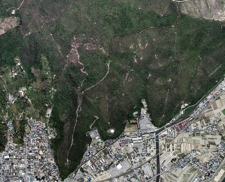
Mount Otakadai hiking routes
Hiking times are estimates calculated from the terrain.
Huts, campsites and lodging near Mount Otakadai
Campsites
- 丸山県民サンビーチ
- 赤穂海浜公園オートキャンプ場
Lodging
- 東横イン
- ホテルニュー浦島
- Ako Royal Hotel
- あこうビジネスホテル 桜館
- 赤穂パークホテル
Lists that include Mount Otakadai
Mount Otakadai facts
- Elevation
- 253 m
- Location
- Akō-shi, Hyogo
34.766519, 134.401025 - Website
- ako-kankou.jp
- Trail Map
- www.city.ako.lg.jp (PDF)
- Wikipedia
- ja.wikipedia.org