
Mount Obi
大尾山
Kakegawa, Shizuoka · Elevation 661 m
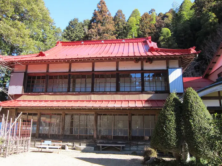
A hiking route starts near the suspension bridge at Narakoko-no-Sato, continues to the trailhead and passes through cedar woods toward Kenkoji Temple and Kannondo Hall. Visitors can enjoy flowering crabapples at Kenkoji in spring and autumn foliage. The Torii cedar at Kannondo fell in a 2018 typhoon, leaving its stump.
Mount Obi at a glance
- Weather: The most settled day in the next 7 days is Thu, November 5: cloudy, gusts up to 5 m/s. Fri, Nov 6, Sat, Nov 7: strong wind (gusts up to 17 m/s).
Mount Obi weather (hourly, 14 days)
Sunrise today 06:10, sunset 16:53
| Tue, 11/3 | Wed, 11/4 | Thu, 11/5 | Fri, 11/6 | Sat, 11/7 | Sun, 11/8 | Mon, 11/9 | Tue, 11/10 | Wed, 11/11 | Thu, 11/12 | Fri, 11/13 | Sat, 11/14 | Sun, 11/15 | Mon, 11/16 | Tue, 11/17 | |||||||||||||||||||||||||||||||||||||||||||||||||||||||||||||||||||||||
|---|---|---|---|---|---|---|---|---|---|---|---|---|---|---|---|---|---|---|---|---|---|---|---|---|---|---|---|---|---|---|---|---|---|---|---|---|---|---|---|---|---|---|---|---|---|---|---|---|---|---|---|---|---|---|---|---|---|---|---|---|---|---|---|---|---|---|---|---|---|---|---|---|---|---|---|---|---|---|---|---|---|---|---|---|---|
| Japan time | 21 | 23 | 1 | 3 | 5 | 7 | 9 | 11 | 13 | 15 | 17 | 19 | 21 | 0 | 3 | 6 | 9 | 12 | 15 | 18 | 21 | 0 | 3 | 6 | 9 | 12 | 15 | 18 | 21 | 0 | 3 | 6 | 9 | 12 | 15 | 18 | 21 | 0 | 3 | 6 | 9 | 12 | 15 | 18 | 21 | 0 | 3 | 6 | 9 | 12 | 15 | 21 | 3 | 9 | 15 | 21 | 3 | 9 | 15 | 21 | 3 | 9 | 15 | 21 | 3 | 9 | 15 | 21 | 3 | 9 | 15 | 21 | 3 | 9 | 15 | 21 | 3 | 9 | 15 | 21 | 3 | 9 | 15 | 21 | |
  |   | |   | |   | | |   |   |   |   | | | | |   | | | | |   | | |  | | |  | | | | | | | | | | | | |   |   | | | | | | | | | | |   | | | | | | | | | | | | | | | |  | | | | | | | | | | | | | | | | ||
| Temperature | °C | 10° | 10° | 10° | 10° | 11° | 12° | 13° | 13° | 14° | 13° | 11° | 11° | 11° | 12° | 12° | 13° | 16° | 18° | 17° | 14° | 13° | 13° | 14° | 13° | 16° | 19° | 18° | 14° | 12° | 11° | 9° | 8° | 11° | 14° | 13° | 9° | 6° | 4° | 6° | 5° | 13° | 15° | 14° | 10° | 11° | 10° | 9° | 9° | 11° | 12° | 14° | 9° | 7° | 11° | 13° | 7° | 7° | 9° | 13° | 4° | 5° | 10° | 12° | 5° | 6° | 11° | 14° | 8° | 6° | 9° | 12° | 6° | 9° | 13° | 12° | 11° | 12° | 15° | 20° | 10° | 11° | 10° | 11° | 8° |
| Precipitation | mm | 0.6 | 3.6 | 0.5 | 4.1 | 6 | 2.7 | 0.4 | 0.1 | 0.1 | 0.2 | 0.5 | 0.1 | 0.1 | 0.2 | 0.3 | 1.3 | 0.2 | 0.2 | 0.4 | 3.2 | 30 | 20 | 14 | |||||||||||||||||||||||||||||||||||||||||||||||||||||||||||||
| New snow | cm | ||||||||||||||||||||||||||||||||||||||||||||||||||||||||||||||||||||||||||||||||||||
| Snow depth | cm | 0 | 0 | 0 | 0 | 0 | 0 | 0 | 0 | 0 | 0 | 0 | 0 | 0 | 0 | 0 | 0 | 0 | 0 | 0 | 0 | 0 | 0 | 0 | 0 | 0 | 0 | 0 | 0 | 0 | 0 | 0 | 0 | 0 | 0 | 0 | 0 | 0 | 0 | 0 | 0 | 0 | 0 | 0 | 0 | 0 | 0 | 0 | 0 | 0 | 0 | 0 | 0 | 0 | 0 | 0 | 0 | 0 | 0 | 0 | 0 | 0 | 0 | 0 | 0 | 0 | 0 | 0 | 0 | 0 | 0 | 0 | 0 | 0 | 0 | 0 | 0 | 0 | 0 | 0 | 0 | 0 | 0 | 0 | 0 |
| Wind | m/s | 2 | 2 | 3 | 2 | 3 | 3 | 4 | 4 | 4 | 5 | 5 | 7 | 7 | 6 | 5 | 3 | 1 | 1 | 2 | 1 | 2 | 3 | 4 | 5 | 6 | 8 | 7 | 7 | 7 | 7 | 6 | 6 | 6 | 7 | 6 | 5 | 3 | 2 | 1 | 1 | 2 | 1 | 2 | 1 | 3 | 3 | 2 | 1 | 1 | 1 | 2 | 3 | 3 | 2 | 3 | 3 | 8 | 5 | 0 | 2 | 1 | 1 | 1 | 1 | 5 | 2 | 2 | 2 | 1 | 2 | 1 | 1 | 0 | 2 | 1 | 1 | 0 | 4 | 6 | 4 | 4 | 3 | 2 | 4 |
| Wind gusts | m/s | 3 | 4 | 5 | 5 | 6 | 7 | 8 | 8 | 9 | 10 | 12 | 14 | 15 | 14 | 13 | 9 | 5 | 3 | 5 | 4 | 3 | 6 | 8 | 11 | 13 | 17 | 17 | 16 | 16 | 15 | 14 | 14 | 14 | 16 | 16 | 14 | 11 | 7 | 3 | 3 | 5 | 6 | 5 | 5 | 7 | 8 | 6 | 4 | 3 | 4 | 6 | 8 | 6 | 6 | 8 | 7 | 17 | 18 | 11 | 5 | 4 | 4 | 5 | 3 | 10 | 10 | 7 | 6 | 5 | 4 | 5 | 4 | 2 | 6 | 7 | 6 | 7 | 8 | 14 | 13 | 11 | 8 | 9 | 8 |
| Wind dir. | ↓ | ↓ | ↓ | ↓ | ↓ | ↓ | ↓ | ↓ | ↓ | ↓ | ↓ | ↓ | ↓ | ↓ | ↓ | ↓ | ↓ | ↓ | ↓ | ↓ | ↓ | ↓ | ↓ | ↓ | ↓ | ↓ | ↓ | ↓ | ↓ | ↓ | ↓ | ↓ | ↓ | ↓ | ↓ | ↓ | ↓ | ↓ | ↓ | ↓ | ↓ | ↓ | ↓ | ↓ | ↓ | ↓ | ↓ | ↓ | ↓ | ↓ | ↓ | ↓ | ↓ | ↓ | ↓ | ↓ | ↓ | ↓ | ↓ | ↓ | ↓ | ↓ | ↓ | ↓ | ↓ | ↓ | ↓ | ↓ | ↓ | ↓ | ↓ | ↓ | ↓ | ↓ | ↓ | ↓ | ↓ | ↓ | ↓ | ↓ | ↓ | ↓ | ↓ | ↓ | |
Huts, campsites and lodging near Mount Obi
Mountain huts
- 掛川市広域避難所:さくら咲く学校
Campsites
- 明ヶ島キャンプ場
- ならここの里キャンプ場
- 萩間キャンプ場
- yoshikawa campsite
Mount Obi facts
- Elevation
- 661 m
- Location
- Kakegawa, Shizuoka
34.891585, 138.014776 - Website
- www.kakegawa-kankou.com
- Trail Map
- www.kakegawa-kankou.com
- Wikipedia
- ja.wikipedia.org