
Mount Kogane
黄金山
Ishikari, Hokkaido · Elevation 739 m
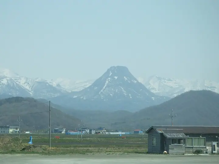
Mount Kogane is a 739.1-meter peak in the Hamamasu district of Ishikari City, Hokkaido, whose elegant cone earns it the nicknames "Hamamasu Fuji" and "Golden Fuji." Known to the Ainu as Pinnetai-Orushipe, "the male mountain that rises from the wooded plain," it was designated a Japanese National Place of Scenic Beauty in 2009 as one of the Pirikanoka ("beautifully shaped") sites associated with Ainu cultural heritage. The peak sits within Shokanbetsu-Teuri-Yagishiri Quasi-National Park and is counted among the 100 famous mountains of Hokkaido.
Mount Kogane at a glance
- Weather: The most settled day in the next 7 days is Thu, November 5: clear, gusts up to 10 m/s. Wed, Nov 4, Fri, Nov 6, Sat, Nov 7, Sun, Nov 8: strong wind (gusts up to 23 m/s).
- Route: The shortest is Mount Kogane Loop via the New and Old Trails: about 2 h 49 min, 3.9 km, about 550 m of climbing.
Mount Kogane weather (hourly, 14 days)
Sunrise today 06:11, sunset 16:24
| Tue, 11/3 | Wed, 11/4 | Thu, 11/5 | Fri, 11/6 | Sat, 11/7 | Sun, 11/8 | Mon, 11/9 | Tue, 11/10 | Wed, 11/11 | Thu, 11/12 | Fri, 11/13 | Sat, 11/14 | Sun, 11/15 | Mon, 11/16 | Tue, 11/17 | |||||||||||||||||||||||||||||||||||||||||||||||||||||||||||||||||||||||
|---|---|---|---|---|---|---|---|---|---|---|---|---|---|---|---|---|---|---|---|---|---|---|---|---|---|---|---|---|---|---|---|---|---|---|---|---|---|---|---|---|---|---|---|---|---|---|---|---|---|---|---|---|---|---|---|---|---|---|---|---|---|---|---|---|---|---|---|---|---|---|---|---|---|---|---|---|---|---|---|---|---|---|---|---|---|
| Japan time | 15 | 17 | 19 | 21 | 23 | 1 | 3 | 5 | 7 | 9 | 11 | 13 | 15 | 18 | 21 | 0 | 3 | 6 | 9 | 12 | 15 | 18 | 21 | 0 | 3 | 6 | 9 | 12 | 15 | 18 | 21 | 0 | 3 | 6 | 9 | 12 | 15 | 18 | 21 | 0 | 3 | 6 | 9 | 12 | 15 | 18 | 21 | 0 | 3 | 6 | 9 | 15 | 21 | 3 | 9 | 15 | 21 | 3 | 9 | 15 | 21 | 3 | 9 | 15 | 21 | 3 | 9 | 15 | 21 | 3 | 9 | 15 | 21 | 3 | 9 | 15 | 21 | 3 | 9 | 15 | 21 | 3 | 9 | 15 | |
  |   |   | | | | |   | |   |   |   |  |  |   | | |   | | | | |   |   | | |   |   | |   |   |   | | | | | | | | | | | | | | | | | | | | | | | | | | |   | | | | | | | | | | | | | | | | | | | |   | | | | |   | ||
| Temperature | °C | 0° | -1° | -1° | -2° | -2° | -2° | -2° | 0° | 0° | 1° | 1° | 1° | 0° | -3° | -3° | -3° | -2° | -1° | 5° | 8° | 7° | 4° | 4° | 5° | 5° | 5° | 8° | 9° | 6° | 2° | -1° | -3° | -4° | -4° | -4° | -4° | -4° | -4° | -4° | -5° | -5° | -4° | -4° | -3° | -3° | -3° | -3° | -4° | -4° | -4° | -3° | -4° | -6° | -9° | -5° | -3° | -12° | -8° | -1° | -1° | -3° | -3° | -1° | -2° | -4° | -5° | -5° | -3° | -5° | -8° | -1° | 0° | -4° | -1° | 2° | 4° | 3° | 2° | 0° | -1° | -4° | -3° | -2° | -1° |
| Precipitation | mm | 0.1 | 0.1 | 0.9 | 2.5 | 4.0 | 4.1 | 0.6 | 0.6 | 0.1 | 4.6 | 8 | 3.2 | 1.0 | 2.4 | 2.9 | 2.0 | 2.5 | 1.8 | 2.1 | 2.0 | 1.6 | 1.4 | 1.6 | 2.1 | 2.2 | 2.0 | 1.8 | 2.1 | 2.2 | 1.7 | 1.4 | 1.2 | 0.6 | 0.6 | 0.3 | 0.1 | 3.1 | 1.8 | 0.7 | 0.5 | 0.3 | 0.3 | 0.2 | 0.2 | 0.8 | 4.0 | 0.5 | 0.9 | 1.5 | 1.5 | 2.2 | 0.8 | 0.1 | 0.8 | 2.8 | 2.2 | 8 | 3.7 | 1.3 | 0.8 | ||||||||||||||||||||||||
| New snow | cm | 0.1 | <.1 | 0.1 | 0.7 | 2.2 | 3.5 | 3.7 | 0.4 | 0.6 | <.1 | 0.9 | 2.4 | 1.8 | 2.1 | 2.0 | 1.6 | 1.4 | 1.6 | 2.1 | 2.2 | 2.0 | 1.8 | 2.1 | 2.2 | 1.7 | 1.4 | 1.2 | 0.6 | 0.5 | 0.3 | 0.2 | 3.1 | 1.8 | 0.7 | 0.5 | 0.3 | 0.3 | 0.2 | 0.2 | 0.7 | 3.8 | 0.5 | 0.9 | 1.5 | 1.5 | 2.2 | 0.8 | 0.9 | 1.0 | 0.8 | <.1 | |||||||||||||||||||||||||||||||||
| Snow depth | cm | 2 | 2 | 2 | 2 | 4 | 6 | 9 | 9 | 9 | 9 | 8 | 8 | 8 | 7 | 7 | 7 | 7 | 7 | 7 | 5 | 4 | 4 | 3 | 3 | 2 | 1 | 1 | <1 | 0 | 0 | <1 | 2 | 3 | 4 | 5 | 6 | 7 | 8 | 9 | 10 | 11 | 12 | 13 | 15 | 16 | 16 | 17 | 17 | 17 | 17 | 17 | 18 | 19 | 20 | 20 | 19 | 19 | 19 | 19 | 18 | 17 | 17 | 17 | 19 | 19 | 20 | 20 | 21 | 22 | 22 | 22 | 21 | 21 | 20 | 19 | 16 | 14 | 13 | 13 | 13 | 13 | 13 | 13 | 13 |
| Wind | m/s | 4 | 4 | 3 | 2 | 1 | 2 | 1 | 6 | 6 | 5 | 4 | 3 | 1 | 1 | 2 | 2 | 3 | 3 | 2 | 2 | 2 | 2 | 2 | 3 | 2 | 3 | 2 | 4 | 5 | 6 | 6 | 7 | 7 | 7 | 7 | 8 | 8 | 8 | 8 | 8 | 8 | 8 | 8 | 7 | 6 | 5 | 4 | 3 | 3 | 3 | 4 | 4 | 2 | 1 | 1 | 1 | 1 | 1 | 0 | 1 | 1 | 1 | 2 | 4 | 3 | 3 | 5 | 5 | 2 | 1 | 2 | 1 | 1 | 2 | 2 | 2 | 2 | 2 | 2 | 4 | 4 | 3 | 2 | 2 |
| Wind gusts | m/s | 14 | 12 | 10 | 10 | 6 | 8 | 8 | 18 | 16 | 16 | 15 | 11 | 8 | 5 | 6 | 7 | 8 | 9 | 9 | 10 | 8 | 6 | 6 | 7 | 7 | 9 | 9 | 13 | 16 | 20 | 18 | 22 | 23 | 22 | 21 | 23 | 23 | 23 | 22 | 23 | 23 | 22 | 21 | 21 | 19 | 17 | 13 | 11 | 9 | 9 | 10 | 12 | 11 | 7 | 4 | 4 | 4 | 4 | 4 | 6 | 5 | 5 | 7 | 13 | 12 | 10 | 14 | 15 | 13 | 6 | 6 | 9 | 5 | 6 | 8 | 9 | 9 | 7 | 6 | 12 | 12 | 10 | 9 | 7 |
| Wind dir. | ↓ | ↓ | ↓ | ↓ | ↓ | ↓ | ↓ | ↓ | ↓ | ↓ | ↓ | ↓ | ↓ | ↓ | ↓ | ↓ | ↓ | ↓ | ↓ | ↓ | ↓ | ↓ | ↓ | ↓ | ↓ | ↓ | ↓ | ↓ | ↓ | ↓ | ↓ | ↓ | ↓ | ↓ | ↓ | ↓ | ↓ | ↓ | ↓ | ↓ | ↓ | ↓ | ↓ | ↓ | ↓ | ↓ | ↓ | ↓ | ↓ | ↓ | ↓ | ↓ | ↓ | ↓ | ↓ | ↓ | ↓ | ↓ | ↓ | ↓ | ↓ | ↓ | ↓ | ↓ | ↓ | ↓ | ↓ | ↓ | ↓ | ↓ | ↓ | ↓ | ↓ | ↓ | ↓ | ↓ | ↓ | ↓ | ↓ | ↓ | ↓ | ↓ | ↓ | ↓ | |
Mount Kogane hiking routes
Hiking times are estimates calculated from the terrain.
Lists that include Mount Kogane
Mount Kogane facts
- Also known as
- 浜益富士 · 黄金富士 · ピンネタイオルシペ
- Elevation
- 739 m
- Location
- Ishikari, Hokkaido
43.624085, 141.473168 - National Park
- 暑寒別天売焼尻国定公園
- Season Opens
- May 17
- Website
- www.city.ishikari.hokkaido.jp
- Trail Map
- www.city.ishikari.hokkaido.jp (PDF)
- Wikipedia
- ja.wikipedia.org