
Mount Kariba
狩場山
Shimamaki, Hokkaido · Elevation 1,520 m
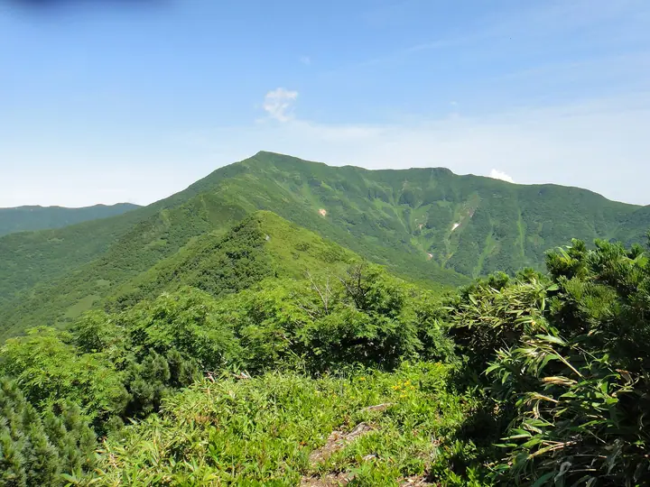
Mount Kariba is a 1,520 m Quaternary andesitic stratovolcano straddling Shimamaki Village in Shimamaki District and Setana Town in Kudō District of southern Hokkaidō, the highest summit of the southern Dōnan region within Karibamotsuta Hokkaidō Prefectural Natural Park. Its name comes from the Ainu "Karimpa-Ushi-Nupuri" — the mountain where karimpa (cherry bark) grows in clusters. It is listed in the Nihon Sanbyaku Meizan and the Hokkaidō Hyakumeizan. Four routes lead to the summit: the Chihasenshindo route (4.3 km, the shortest) and the Makomanai route (8 km) on the Shimamaki side, and the Motsuta route (14 km) and the Chihaseyū-michi route (6 km, lightly maintained and prone to overgrowth) on the Setana side. The summit ridge holds extensive haimatsu and alpine flower fields, with views over the Sea of Japan to Mount Shari and Mount Yōtei. The climbing season generally runs from late June through late October.
Mount Kariba at a glance
- Weather: The most settled day in the next 7 days is Thu, November 5: clear, gusts up to 10 m/s. Wed, Nov 4, Fri, Nov 6, Sat, Nov 7, Sun, Nov 8: strong wind (gusts up to 28 m/s).
Mount Kariba weather (hourly, 14 days)
Sunrise today 06:15, sunset 16:32
| Tue, 11/3 | Wed, 11/4 | Thu, 11/5 | Fri, 11/6 | Sat, 11/7 | Sun, 11/8 | Mon, 11/9 | Tue, 11/10 | Wed, 11/11 | Thu, 11/12 | Fri, 11/13 | Sat, 11/14 | Sun, 11/15 | Mon, 11/16 | Tue, 11/17 | |||||||||||||||||||||||||||||||||||||||||||||||||||||||||||||||||||||||
|---|---|---|---|---|---|---|---|---|---|---|---|---|---|---|---|---|---|---|---|---|---|---|---|---|---|---|---|---|---|---|---|---|---|---|---|---|---|---|---|---|---|---|---|---|---|---|---|---|---|---|---|---|---|---|---|---|---|---|---|---|---|---|---|---|---|---|---|---|---|---|---|---|---|---|---|---|---|---|---|---|---|---|---|---|---|
| Japan time | 15 | 17 | 19 | 21 | 23 | 1 | 3 | 5 | 7 | 9 | 11 | 13 | 15 | 18 | 21 | 0 | 3 | 6 | 9 | 12 | 15 | 18 | 21 | 0 | 3 | 6 | 9 | 12 | 15 | 18 | 21 | 0 | 3 | 6 | 9 | 12 | 15 | 18 | 21 | 0 | 3 | 6 | 9 | 12 | 15 | 18 | 21 | 0 | 3 | 6 | 9 | 15 | 21 | 3 | 9 | 15 | 21 | 3 | 9 | 15 | 21 | 3 | 9 | 15 | 21 | 3 | 9 | 15 | 21 | 3 | 9 | 15 | 21 | 3 | 9 | 15 | 21 | 3 | 9 | 15 | 21 | 3 | 9 | 15 | |
  |   |   |   |   | |   |   |   | |  | | |  | | | | | | |   | | |   | | |   |   | | | | | |   |   |   | | | |   | | | | | | | | | | | | |   | |   | | | | |   | | | | | | | | | | | | | | | | | | | | | | | | | ||
| Temperature | °C | -2° | -2° | -2° | -1° | -1° | -1° | -1° | -2° | -2° | -2° | -1° | 0° | 0° | -3° | -1° | 1° | 1° | 2° | 5° | 7° | 7° | 2° | 3° | 4° | 3° | 4° | 5° | 4° | 1° | -3° | -5° | -7° | -7° | -8° | -8° | -7° | -6° | -6° | -6° | -7° | -7° | -7° | -6° | -6° | -6° | -6° | -6° | -6° | -7° | -7° | -7° | -7° | -7° | -8° | -6° | -6° | -7° | -7° | -4° | -4° | -5° | -5° | -4° | -4° | -6° | -6° | -8° | -6° | -6° | -6° | -3° | -2° | -2° | 0° | 2° | 2° | 2° | -1° | -3° | -6° | -6° | -5° | -4° | -3° |
| Precipitation | mm | 0.1 | 0.6 | 1.6 | 3.2 | 0.3 | 1.5 | 1.2 | 0.5 | 0.2 | 2.7 | 4.5 | 0.6 | 1.2 | 2.1 | 2.6 | 2.2 | 2.4 | 2.4 | 2.2 | 1.7 | 1.6 | 1.9 | 1.5 | 1.6 | 1.3 | 0.9 | 0.5 | 0.2 | 0.1 | 0.1 | 0.2 | 1.8 | 0.9 | 0.4 | 2.9 | 0.5 | 0.3 | 0.8 | 0.2 | 0.7 | 4.7 | 2.8 | 1.6 | 5 | 6 | 2.2 | 0.5 | |||||||||||||||||||||||||||||||||||||
| New snow | cm | <.1 | 0.2 | <.1 | 0.2 | 0.7 | 2.1 | 2.5 | 2.2 | 2.4 | 2.4 | 2.2 | 1.7 | 1.6 | 1.9 | 1.5 | 1.6 | 1.3 | 0.9 | 0.5 | 0.2 | <.1 | <.1 | 0.1 | <.1 | 0.1 | <.1 | 0.2 | <.1 | <.1 | 1.8 | 0.9 | 0.1 | <.1 | 1.9 | 0.2 | 0.3 | 0.8 | 0.2 | <.1 | 0.8 | 1.3 | 0.5 | ||||||||||||||||||||||||||||||||||||||||||
| Snow depth | cm | <1 | <1 | <1 | <1 | <1 | <1 | <1 | <1 | <1 | <1 | <1 | <1 | <1 | 0 | 0 | 0 | 0 | 0 | 0 | 0 | 0 | 0 | 0 | 0 | 0 | 0 | 0 | 0 | 0 | 0 | <1 | 1 | 2 | 3 | 3 | 3 | 4 | 5 | 5 | 6 | 6 | 6 | 6 | 7 | 7 | 7 | 7 | 6 | 6 | 6 | 6 | 6 | 6 | 6 | 6 | 6 | 6 | 7 | 7 | 7 | 7 | 7 | 8 | 7 | 7 | 7 | 7 | 7 | 7 | 7 | 7 | 6 | 5 | 4 | 2 | 1 | <1 | <1 | <1 | 1 | 2 | 2 | 1 | 1 |
| Wind | m/s | 5 | 6 | 5 | 5 | 7 | 6 | 8 | 7 | 6 | 5 | 3 | 2 | 3 | 4 | 4 | 5 | 4 | 4 | 3 | 1 | 1 | 2 | 2 | 1 | 2 | 4 | 5 | 6 | 8 | 8 | 9 | 8 | 9 | 9 | 9 | 10 | 11 | 10 | 10 | 11 | 11 | 10 | 10 | 9 | 7 | 7 | 6 | 5 | 5 | 4 | 5 | 5 | 4 | 3 | 1 | 4 | 4 | 4 | 2 | 3 | 2 | 3 | 4 | 5 | 4 | 5 | 6 | 5 | 3 | 1 | 2 | 3 | 3 | 5 | 6 | 5 | 4 | 4 | 5 | 6 | 6 | 4 | 3 | 4 |
| Wind gusts | m/s | 15 | 15 | 15 | 15 | 20 | 22 | 20 | 20 | 18 | 15 | 13 | 8 | 9 | 10 | 12 | 12 | 14 | 12 | 10 | 9 | 7 | 5 | 6 | 6 | 8 | 13 | 14 | 19 | 24 | 22 | 24 | 25 | 24 | 25 | 26 | 26 | 28 | 28 | 27 | 28 | 28 | 28 | 26 | 24 | 22 | 19 | 17 | 16 | 14 | 13 | 13 | 14 | 12 | 11 | 9 | 11 | 13 | 12 | 11 | 13 | 9 | 9 | 11 | 15 | 12 | 13 | 17 | 16 | 13 | 9 | 7 | 10 | 9 | 14 | 16 | 16 | 14 | 12 | 13 | 17 | 17 | 16 | 12 | 10 |
| Wind dir. | ↓ | ↓ | ↓ | ↓ | ↓ | ↓ | ↓ | ↓ | ↓ | ↓ | ↓ | ↓ | ↓ | ↓ | ↓ | ↓ | ↓ | ↓ | ↓ | ↓ | ↓ | ↓ | ↓ | ↓ | ↓ | ↓ | ↓ | ↓ | ↓ | ↓ | ↓ | ↓ | ↓ | ↓ | ↓ | ↓ | ↓ | ↓ | ↓ | ↓ | ↓ | ↓ | ↓ | ↓ | ↓ | ↓ | ↓ | ↓ | ↓ | ↓ | ↓ | ↓ | ↓ | ↓ | ↓ | ↓ | ↓ | ↓ | ↓ | ↓ | ↓ | ↓ | ↓ | ↓ | ↓ | ↓ | ↓ | ↓ | ↓ | ↓ | ↓ | ↓ | ↓ | ↓ | ↓ | ↓ | ↓ | ↓ | ↓ | ↓ | ↓ | ↓ | ↓ | ↓ | |
Huts, campsites and lodging near Mount Kariba
Campsites
- 賀老高原キャンプ場
Lists that include Mount Kariba
Japan's 300 Famous Mountains · Hokkaido 100 Famous Mountains · Elevations of 1003 Mountains of Japan · 1000 Mountains of Japan
Mount Kariba facts
- Elevation
- 1,520 m
- Location
- Shimamaki, Hokkaido
42.613342, 139.940608 - Website
- www.rinya.maff.go.jp
- Trail Map
- www.rinya.maff.go.jp (PDF)
- Access Information
- www.vill.shimamaki.lg.jp
- Wikipedia
- ja.wikipedia.org