
Mount Daisengen
大千軒岳
Matsumae, Hokkaido · Elevation 1,072 m
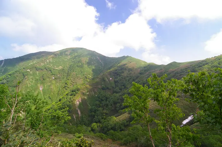
Mount Daisengen is a 1,072 m peak rising at the meeting point of Matsumae and Fukushima towns in Matsumae District and Kaminokuni Town in Hiyama District in southwestern Hokkaidō, the site of Hokkaidō's first first-order triangulation marker, installed in 1896. It is listed in the Nihon Sanbyaku Meizan, the Hana no Hyakumeizan, and the Hokkaidō Hyakumeizan, and is celebrated for the early-summer profusion of shiraneaoi, chishima-fūro, and sankayō wildflowers on its slopes. The Sengen-daira col was the site of the 1639 Matsumae-han execution of 106 hidden Christians (Kakure Kirishitan); a cross now stands there and a memorial Mass is held on the last Sunday of every July. The standard ascents are the Sengen (Shirikuchi-gawa) route from the Okufutamata trailhead beside the old gold-mining station in Fukushima, the Shindō ("new road") route, and the Kyūdō ("old road") route — both reached from Ishizaki in Matsumae via Hokkaidō Route 607. Forest-road closures and bear sightings periodically restrict access; pre-checking conditions is advised.
Mount Daisengen at a glance
- Weather: The most settled day in the next 7 days is Thu, November 5: cloudy, gusts up to 6 m/s. Fri, Nov 6, Sat, Nov 7, Sun, Nov 8: strong wind (gusts up to 24 m/s).
Mount Daisengen weather (hourly, 14 days)
Sunrise today 06:13, sunset 16:33
| Tue, 11/3 | Wed, 11/4 | Thu, 11/5 | Fri, 11/6 | Sat, 11/7 | Sun, 11/8 | Mon, 11/9 | Tue, 11/10 | Wed, 11/11 | Thu, 11/12 | Fri, 11/13 | Sat, 11/14 | Sun, 11/15 | Mon, 11/16 | Tue, 11/17 | |||||||||||||||||||||||||||||||||||||||||||||||||||||||||||||||||||||||
|---|---|---|---|---|---|---|---|---|---|---|---|---|---|---|---|---|---|---|---|---|---|---|---|---|---|---|---|---|---|---|---|---|---|---|---|---|---|---|---|---|---|---|---|---|---|---|---|---|---|---|---|---|---|---|---|---|---|---|---|---|---|---|---|---|---|---|---|---|---|---|---|---|---|---|---|---|---|---|---|---|---|---|---|---|---|
| Japan time | 15 | 17 | 19 | 21 | 23 | 1 | 3 | 5 | 7 | 9 | 11 | 13 | 15 | 18 | 21 | 0 | 3 | 6 | 9 | 12 | 15 | 18 | 21 | 0 | 3 | 6 | 9 | 12 | 15 | 18 | 21 | 0 | 3 | 6 | 9 | 12 | 15 | 18 | 21 | 0 | 3 | 6 | 9 | 12 | 15 | 18 | 21 | 0 | 3 | 6 | 9 | 15 | 21 | 3 | 9 | 15 | 21 | 3 | 9 | 15 | 21 | 3 | 9 | 15 | 21 | 3 | 9 | 15 | 21 | 3 | 9 | 15 | 21 | 3 | 9 | 15 | 21 | 3 | 9 | 15 | 21 | 3 | 9 | 15 | |
  |   |   |  | |   |   | | |  | | | |  | | | | |   | |   | | | | | |   |   | | |   |   |   | |   |   | | | | | | | | | | |   | | | | | | |   |   | | | | | | | | |   | | | | | | | | | | | | | | | | | | | | | ||
| Temperature | °C | 2° | 0° | 0° | 1° | 0° | 2° | 3° | 2° | 1° | 3° | 4° | 4° | 4° | -2° | -2° | 0° | -1° | -1° | 7° | 10° | 9° | 5° | 5° | 5° | 6° | 6° | 9° | 8° | 5° | 1° | -2° | -3° | -3° | -4° | -3° | -3° | -3° | -3° | -3° | -4° | -4° | -4° | -3° | -2° | -3° | -3° | -3° | -3° | -4° | -4° | -2° | -3° | -5° | -5° | -3° | -2° | -4° | -4° | -2° | 0° | -4° | -6° | 0° | -1° | -3° | -4° | -2° | -3° | -5° | -7° | 0° | 1° | -3° | 1° | 4° | 6° | 3° | 2° | 1° | -1° | -3° | -2° | 0° | 1° |
| Precipitation | mm | 1.2 | 0.8 | 0.4 | 0.2 | 0.3 | 2.5 | 0.2 | 1.0 | 2.0 | 0.2 | 0.4 | 0.6 | 0.7 | 0.9 | 1.1 | 1.4 | 1.5 | 0.9 | 0.4 | 1.0 | 1.3 | 0.5 | 0.4 | 0.4 | 0.1 | 0.1 | 0.1 | 1.1 | 12 | 3.9 | 0.4 | 1.5 | 0.9 | 0.5 | 0.3 | 0.1 | 0.9 | 1.0 | 4.5 | 3.3 | 1.4 | 0.8 | 0.6 | |||||||||||||||||||||||||||||||||||||||||
| New snow | cm | 0.1 | 0.6 | 0.6 | 1.0 | 1.1 | 1.4 | 1.4 | 0.9 | 0.4 | 1.0 | 1.3 | 0.5 | 0.4 | 0.4 | 0.1 | 0.1 | 0.1 | <.1 | 1.1 | 12 | 3.9 | <.1 | 0.1 | 0.5 | 0.3 | <.1 | 0.6 | |||||||||||||||||||||||||||||||||||||||||||||||||||||||||
| Snow depth | cm | 0 | 0 | 0 | 0 | 0 | 0 | 0 | 0 | 0 | 0 | 0 | 0 | 0 | 0 | 0 | 0 | 0 | 0 | 0 | 0 | 0 | 0 | 0 | 0 | 0 | 0 | 0 | 0 | 0 | 0 | 0 | <1 | <1 | 1 | 1 | 2 | 3 | 3 | 3 | 4 | 4 | 5 | 5 | 5 | 5 | 5 | 5 | 5 | 5 | 4 | 4 | 4 | 4 | 4 | 4 | 4 | 4 | 11 | 13 | 12 | 11 | 11 | 10 | 8 | 7 | 7 | 7 | 7 | 7 | 7 | 7 | 6 | 6 | 6 | 4 | 2 | 1 | <1 | <1 | 0 | <1 | <1 | <1 | 0 |
| Wind | m/s | 6 | 4 | 4 | 3 | 4 | 7 | 7 | 6 | 6 | 5 | 4 | 3 | 2 | 0 | 0 | 1 | 1 | 1 | 1 | 2 | 1 | 1 | 1 | 0 | 1 | 2 | 3 | 6 | 8 | 8 | 8 | 7 | 8 | 8 | 8 | 9 | 7 | 8 | 8 | 8 | 8 | 8 | 8 | 8 | 7 | 6 | 6 | 5 | 4 | 4 | 5 | 5 | 2 | 2 | 1 | 3 | 7 | 7 | 1 | 2 | 2 | 2 | 5 | 2 | 3 | 3 | 4 | 5 | 2 | 1 | 2 | 2 | 2 | 2 | 3 | 3 | 1 | 1 | 5 | 6 | 4 | 5 | 4 | 4 |
| Wind gusts | m/s | 16 | 15 | 11 | 10 | 10 | 18 | 19 | 17 | 15 | 14 | 13 | 10 | 8 | 5 | 3 | 4 | 4 | 3 | 4 | 5 | 6 | 4 | 5 | 5 | 4 | 7 | 9 | 16 | 20 | 21 | 22 | 22 | 21 | 22 | 22 | 23 | 24 | 22 | 21 | 22 | 21 | 21 | 21 | 21 | 20 | 19 | 17 | 15 | 12 | 12 | 13 | 14 | 12 | 7 | 5 | 10 | 17 | 19 | 18 | 6 | 7 | 6 | 14 | 16 | 9 | 10 | 11 | 14 | 12 | 6 | 5 | 8 | 7 | 6 | 8 | 12 | 8 | 6 | 12 | 17 | 16 | 12 | 12 | 12 |
| Wind dir. | ↓ | ↓ | ↓ | ↓ | ↓ | ↓ | ↓ | ↓ | ↓ | ↓ | ↓ | ↓ | ↓ | ↓ | ↓ | ↓ | ↓ | ↓ | ↓ | ↓ | ↓ | ↓ | ↓ | ↓ | ↓ | ↓ | ↓ | ↓ | ↓ | ↓ | ↓ | ↓ | ↓ | ↓ | ↓ | ↓ | ↓ | ↓ | ↓ | ↓ | ↓ | ↓ | ↓ | ↓ | ↓ | ↓ | ↓ | ↓ | ↓ | ↓ | ↓ | ↓ | ↓ | ↓ | ↓ | ↓ | ↓ | ↓ | ↓ | ↓ | ↓ | ↓ | ↓ | ↓ | ↓ | ↓ | ↓ | ↓ | ↓ | ↓ | ↓ | ↓ | ↓ | ↓ | ↓ | ↓ | ↓ | ↓ | ↓ | ↓ | ↓ | ↓ | ↓ | ↓ | |
Lists that include Mount Daisengen
Japan's 300 Famous Mountains · 100 Famous Mountains of Flowers · Hokkaido 100 Famous Mountains · Elevations of 1003 Mountains of Japan · 1000 Mountains of Japan
Mount Daisengen facts
- Elevation
- 1,072 m
- Location
- Matsumae, Hokkaido
41.579265, 140.161123 - Website
- be-happy-fukushima.com
- Trail Map
- www.town.fukushima.hokkaido.jp
- Access Information
- www.oshima.pref.hokkaido.lg.jp
- Wikipedia
- ja.wikipedia.org