
Asakumayama
朝熊山
Ise, Mie · Elevation 500 m
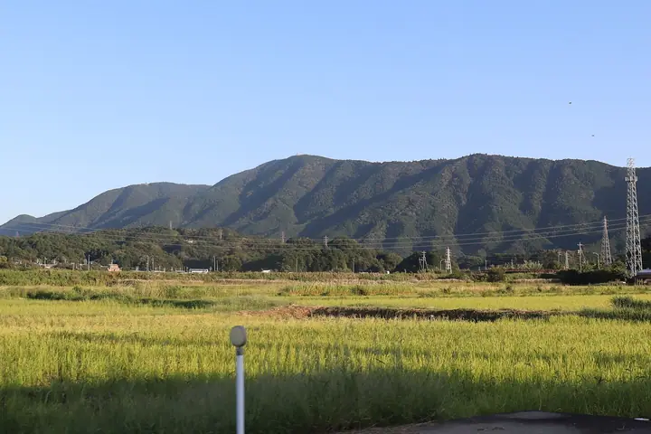
Asakumayama (Mt. Asakuma) is the common name for the massif centered on Asakumagatake (555 m) on the border of Ise City and Toba City, Mie Prefecture. Regarded as the guardian against the "demon gate" of the Ise Grand Shrine, it carries Kongoshoji temple on its heights and lies within Ise-Shima National Park, with the Asamatakemichi pilgrimage trail rising from its foot. It does not appear in any renowned mountain list.
Asakumayama at a glance
- Weather: The most settled day in the next 7 days is Thu, November 5: clear, gusts up to 6 m/s. Fri, Nov 6, Sat, Nov 7: strong wind (gusts up to 18 m/s).
Asakumayama weather (hourly, 14 days)
Sunrise today 06:14, sunset 16:59
| Tue, 11/3 | Wed, 11/4 | Thu, 11/5 | Fri, 11/6 | Sat, 11/7 | Sun, 11/8 | Mon, 11/9 | Tue, 11/10 | Wed, 11/11 | Thu, 11/12 | Fri, 11/13 | Sat, 11/14 | Sun, 11/15 | Mon, 11/16 | Tue, 11/17 | |||||||||||||||||||||||||||||||||||||||||||||||||||||||||||||||||||||||
|---|---|---|---|---|---|---|---|---|---|---|---|---|---|---|---|---|---|---|---|---|---|---|---|---|---|---|---|---|---|---|---|---|---|---|---|---|---|---|---|---|---|---|---|---|---|---|---|---|---|---|---|---|---|---|---|---|---|---|---|---|---|---|---|---|---|---|---|---|---|---|---|---|---|---|---|---|---|---|---|---|---|---|---|---|---|
| Japan time | 21 | 23 | 1 | 3 | 5 | 7 | 9 | 11 | 13 | 15 | 17 | 19 | 21 | 0 | 3 | 6 | 9 | 12 | 15 | 18 | 21 | 0 | 3 | 6 | 9 | 12 | 15 | 18 | 21 | 0 | 3 | 6 | 9 | 12 | 15 | 18 | 21 | 0 | 3 | 6 | 9 | 12 | 15 | 18 | 21 | 0 | 3 | 6 | 9 | 12 | 15 | 21 | 3 | 9 | 15 | 21 | 3 | 9 | 15 | 21 | 3 | 9 | 15 | 21 | 3 | 9 | 15 | 21 | 3 | 9 | 15 | 21 | 3 | 9 | 15 | 21 | 3 | 9 | 15 | 21 | 3 | 9 | 15 | 21 | |
  | | | |   |   | |   | |   |   | | | | |   |   |   | | |   |   | |  |  | | | | | | | | | | | | | | | | | | | | | | | | | | | |   | |   | | | | | |  | | | | | | | | | | | | | | | | | | | |  | | | | ||
| Temperature | °C | 12° | 10° | 10° | 9° | 9° | 10° | 13° | 14° | 14° | 14° | 14° | 13° | 13° | 13° | 13° | 13° | 14° | 18° | 19° | 14° | 15° | 15° | 14° | 14° | 16° | 19° | 18° | 15° | 12° | 11° | 9° | 8° | 11° | 13° | 12° | 9° | 8° | 8° | 8° | 7° | 10° | 13° | 13° | 9° | 9° | 9° | 10° | 9° | 11° | 15° | 15° | 9° | 7° | 12° | 15° | 10° | 8° | 10° | 11° | 8° | 6° | 10° | 13° | 7° | 6° | 12° | 12° | 8° | 5° | 10° | 14° | 8° | 8° | 13° | 14° | 13° | 12° | 16° | 16° | 10° | 7° | 9° | 13° | 8° |
| Precipitation | mm | 0.5 | 0.5 | 0.5 | 1.0 | 2.0 | 0.5 | 0.8 | 0.7 | 0.5 | 0.2 | 0.3 | 0.2 | 0.1 | 2.8 | 8 | 15 | ||||||||||||||||||||||||||||||||||||||||||||||||||||||||||||||||||||
| New snow | cm | ||||||||||||||||||||||||||||||||||||||||||||||||||||||||||||||||||||||||||||||||||||
| Snow depth | cm | 0 | 0 | 0 | 0 | 0 | 0 | 0 | 0 | 0 | 0 | 0 | 0 | 0 | 0 | 0 | 0 | 0 | 0 | 0 | 0 | 0 | 0 | 0 | 0 | 0 | 0 | 0 | 0 | 0 | 0 | 0 | 0 | 0 | 0 | 0 | 0 | 0 | 0 | 0 | 0 | 0 | 0 | 0 | 0 | 0 | 0 | 0 | 0 | 0 | 0 | 0 | 0 | 0 | 0 | 0 | 0 | 0 | 0 | 0 | 0 | 0 | 0 | 0 | 0 | 0 | 0 | 0 | 0 | 0 | 0 | 0 | 0 | 0 | 0 | 0 | 0 | 0 | 0 | 0 | 0 | 0 | 0 | 0 | 0 |
| Wind | m/s | 3 | 3 | 3 | 3 | 3 | 3 | 2 | 3 | 2 | 1 | 4 | 4 | 3 | 2 | 3 | 3 | 2 | 1 | 1 | 2 | 2 | 2 | 1 | 5 | 6 | 7 | 6 | 5 | 5 | 5 | 6 | 6 | 6 | 8 | 8 | 7 | 5 | 5 | 6 | 6 | 5 | 5 | 3 | 3 | 2 | 2 | 2 | 2 | 3 | 5 | 5 | 3 | 2 | 2 | 1 | 4 | 8 | 8 | 8 | 7 | 4 | 4 | 4 | 3 | 2 | 6 | 8 | 6 | 3 | 2 | 1 | 1 | 2 | 1 | 2 | 3 | 2 | 4 | 8 | 6 | 7 | 5 | 3 | 3 |
| Wind gusts | m/s | 7 | 6 | 6 | 6 | 6 | 6 | 6 | 7 | 6 | 5 | 8 | 9 | 9 | 9 | 7 | 7 | 6 | 5 | 4 | 4 | 4 | 5 | 7 | 12 | 14 | 15 | 15 | 12 | 12 | 11 | 13 | 13 | 14 | 18 | 18 | 18 | 15 | 12 | 13 | 14 | 13 | 13 | 12 | 8 | 6 | 5 | 5 | 7 | 6 | 11 | 12 | 10 | 6 | 5 | 5 | 9 | 18 | 19 | 22 | 18 | 15 | 10 | 10 | 9 | 6 | 13 | 18 | 17 | 13 | 6 | 5 | 4 | 4 | 4 | 8 | 8 | 10 | 10 | 19 | 17 | 15 | 14 | 12 | 7 |
| Wind dir. | ↓ | ↓ | ↓ | ↓ | ↓ | ↓ | ↓ | ↓ | ↓ | ↓ | ↓ | ↓ | ↓ | ↓ | ↓ | ↓ | ↓ | ↓ | ↓ | ↓ | ↓ | ↓ | ↓ | ↓ | ↓ | ↓ | ↓ | ↓ | ↓ | ↓ | ↓ | ↓ | ↓ | ↓ | ↓ | ↓ | ↓ | ↓ | ↓ | ↓ | ↓ | ↓ | ↓ | ↓ | ↓ | ↓ | ↓ | ↓ | ↓ | ↓ | ↓ | ↓ | ↓ | ↓ | ↓ | ↓ | ↓ | ↓ | ↓ | ↓ | ↓ | ↓ | ↓ | ↓ | ↓ | ↓ | ↓ | ↓ | ↓ | ↓ | ↓ | ↓ | ↓ | ↓ | ↓ | ↓ | ↓ | ↓ | ↓ | ↓ | ↓ | ↓ | ↓ | ↓ | |
Huts, campsites and lodging near Asakumayama
Lodging
- AUBERGE YUSURA
- Taikoji Youth Hostel
Asakumayama facts
- Also known as
- 朝熊ヶ岳
- Elevation
- 500 m
- Location
- Ise, Mie
34.460415, 136.791099 - National Park
- 伊勢志摩国立公園
- Website
- www.iseshima-kanko.jp
- Trail Map
- www.iseshima-kanko.jp
- Wikipedia
- ja.wikipedia.org