
Mt. Yokogurayama
横倉山
Ochi, Kochi · Elevation 800 m
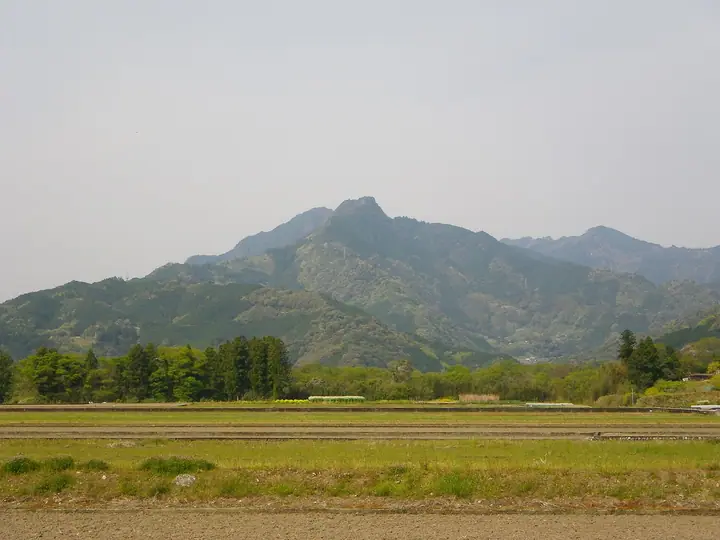
Mt. Yokogurayama is an approximately 800-meter peak in Ochi Town, Takaoka District, Kochi Prefecture, designated as Yokogurayama Prefectural Natural Park. It contains some of Japan's oldest geological formations, including conodont fossils about 450 million years old, and supports roughly 1,300 plant species. The mountain was a research field for botanist Tomitaro Makino, who described new species there such as Yokogura-no-ki and Yokogura-tsukubane. It holds a reference site for the mausoleum of Emperor Antoku and was historically the only Shugendo training mountain in Tosa Province. It is featured in Hana no Hyakumeizan, Shikoku Hyakumeizan, and several other renowned Shikoku mountain lists.
Mt. Yokogurayama at a glance
- Weather: The most settled day in the next 7 days is Wed, November 4: clear, gusts up to 5 m/s.
Mt. Yokogurayama weather (hourly, 14 days)
Sunrise today 06:27, sunset 17:15
| Tue, 11/3 | Wed, 11/4 | Thu, 11/5 | Fri, 11/6 | Sat, 11/7 | Sun, 11/8 | Mon, 11/9 | Tue, 11/10 | Wed, 11/11 | Thu, 11/12 | Fri, 11/13 | Sat, 11/14 | Sun, 11/15 | Mon, 11/16 | Tue, 11/17 | |||||||||||||||||||||||||||||||||||||||||||||||||||||||||||||||||||||||
|---|---|---|---|---|---|---|---|---|---|---|---|---|---|---|---|---|---|---|---|---|---|---|---|---|---|---|---|---|---|---|---|---|---|---|---|---|---|---|---|---|---|---|---|---|---|---|---|---|---|---|---|---|---|---|---|---|---|---|---|---|---|---|---|---|---|---|---|---|---|---|---|---|---|---|---|---|---|---|---|---|---|---|---|---|---|
| Japan time | 15 | 17 | 19 | 21 | 23 | 1 | 3 | 5 | 7 | 9 | 11 | 13 | 15 | 18 | 21 | 0 | 3 | 6 | 9 | 12 | 15 | 18 | 21 | 0 | 3 | 6 | 9 | 12 | 15 | 18 | 21 | 0 | 3 | 6 | 9 | 12 | 15 | 18 | 21 | 0 | 3 | 6 | 9 | 12 | 15 | 18 | 21 | 0 | 3 | 6 | 9 | 15 | 21 | 3 | 9 | 15 | 21 | 3 | 9 | 15 | 21 | 3 | 9 | 15 | 21 | 3 | 9 | 15 | 21 | 3 | 9 | 15 | 21 | 3 | 9 | 15 | 21 | 3 | 9 | 15 | 21 | 3 | 9 | 15 | |
  |   |   | | |   | | |   | | | | |   | | |   | |   | |   | | | | | | | |  |  | | | | | | | | | | | | | | | | | | | | | | |   | | | | | | | | | | | | |  | | | | | | | | | |   |   | | | | |  | | | ||
| Temperature | °C | 16° | 12° | 9° | 7° | 7° | 6° | 7° | 6° | 7° | 12° | 14° | 14° | 15° | 10° | 12° | 11° | 12° | 11° | 13° | 18° | 17° | 14° | 14° | 13° | 13° | 11° | 13° | 16° | 15° | 10° | 8° | 6° | 5° | 4° | 8° | 12° | 12° | 5° | 2° | 1° | 1° | 1° | 10° | 13° | 12° | 8° | 7° | 5° | 5° | 7° | 11° | 14° | 5° | 3° | 10° | 13° | 5° | 4° | 6° | 11° | 1° | 0° | 8° | 12° | 3° | 1° | 9° | 13° | 3° | 0° | 10° | 12° | 5° | 7° | 11° | 13° | 10° | 11° | 14° | 16° | 8° | 3° | 10° | 13° |
| Precipitation | mm | 0.2 | 0.8 | 1.1 | 0.5 | 0.4 | 0.7 | 0.1 | 1.5 | 6 | |||||||||||||||||||||||||||||||||||||||||||||||||||||||||||||||||||||||||||
| New snow | cm | ||||||||||||||||||||||||||||||||||||||||||||||||||||||||||||||||||||||||||||||||||||
| Snow depth | cm | 0 | 0 | 0 | 0 | 0 | 0 | 0 | 0 | 0 | 0 | 0 | 0 | 0 | 0 | 0 | 0 | 0 | 0 | 0 | 0 | 0 | 0 | 0 | 0 | 0 | 0 | 0 | 0 | 0 | 0 | 0 | 0 | 0 | 0 | 0 | 0 | 0 | 0 | 0 | 0 | 0 | 0 | 0 | 0 | 0 | 0 | 0 | 0 | 0 | 0 | 0 | 0 | 0 | 0 | 0 | 0 | 0 | 0 | 0 | 0 | 0 | 0 | 0 | 0 | 0 | 0 | 0 | 0 | 0 | 0 | 0 | 0 | 0 | 0 | 0 | 0 | 0 | 0 | 0 | 0 | 0 | 0 | 0 | 0 |
| Wind | m/s | 2 | 1 | 2 | 2 | 2 | 2 | 2 | 2 | 2 | 1 | 1 | 0 | 1 | 2 | 2 | 1 | 1 | 1 | 2 | 0 | 2 | 0 | 0 | 1 | 3 | 2 | 2 | 5 | 4 | 3 | 4 | 3 | 1 | 1 | 1 | 1 | 1 | 1 | 2 | 2 | 2 | 2 | 1 | 1 | 2 | 1 | 1 | 2 | 2 | 2 | 1 | 3 | 2 | 3 | 2 | 4 | 2 | 1 | 2 | 2 | 3 | 2 | 1 | 2 | 3 | 2 | 1 | 2 | 2 | 1 | 0 | 2 | 1 | 1 | 1 | 0 | 1 | 3 | 1 | 3 | 1 | 2 | 1 | 1 |
| Wind gusts | m/s | 6 | 6 | 4 | 5 | 5 | 5 | 5 | 5 | 5 | 5 | 4 | 4 | 3 | 4 | 4 | 4 | 4 | 3 | 3 | 4 | 7 | 6 | 4 | 4 | 9 | 9 | 7 | 12 | 13 | 11 | 11 | 11 | 9 | 5 | 5 | 5 | 5 | 4 | 6 | 6 | 5 | 5 | 5 | 5 | 5 | 5 | 2 | 4 | 5 | 6 | 5 | 8 | 7 | 7 | 8 | 11 | 9 | 8 | 6 | 6 | 6 | 6 | 6 | 7 | 7 | 7 | 5 | 5 | 6 | 5 | 4 | 8 | 6 | 4 | 4 | 5 | 6 | 8 | 10 | 10 | 7 | 5 | 5 | 7 |
| Wind dir. | ↓ | ↓ | ↓ | ↓ | ↓ | ↓ | ↓ | ↓ | ↓ | ↓ | ↓ | ↓ | ↓ | ↓ | ↓ | ↓ | ↓ | ↓ | ↓ | ↓ | ↓ | ↓ | ↓ | ↓ | ↓ | ↓ | ↓ | ↓ | ↓ | ↓ | ↓ | ↓ | ↓ | ↓ | ↓ | ↓ | ↓ | ↓ | ↓ | ↓ | ↓ | ↓ | ↓ | ↓ | ↓ | ↓ | ↓ | ↓ | ↓ | ↓ | ↓ | ↓ | ↓ | ↓ | ↓ | ↓ | ↓ | ↓ | ↓ | ↓ | ↓ | ↓ | ↓ | ↓ | ↓ | ↓ | ↓ | ↓ | ↓ | ↓ | ↓ | ↓ | ↓ | ↓ | ↓ | ↓ | ↓ | ↓ | ↓ | ↓ | ↓ | ↓ | ↓ | ↓ | |
Huts, campsites and lodging near Mt. Yokogurayama
Campsites
- 小浜キャンプ場
Lists that include Mt. Yokogurayama
100 Famous Mountains of Flowers · Shikoku 100 Famous Mountains
Mt. Yokogurayama facts
- Elevation
- 800 m
- Location
- Ochi, Kochi
33.535081, 133.203322 - Website
- www.town.ochi.kochi.jp
- Trail Map
- www.yokogurayama-museum.jp (PDF)
- Access Information
- kochi-tabi.jp
- Wikipedia
- ja.wikipedia.org