
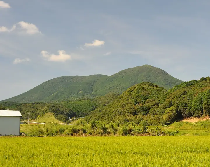
Mt. Yasumandake
安満岳
Hirado, Nagasaki · Elevation 530 m
An approximately 530-meter peak — the highest summit of Hirado Island in Hirado City, Nagasaki Prefecture — and a sacred site registered as a component of the UNESCO World Heritage "Sacred Sites and Pilgrimage Routes in the Hidden Christian Sites in the Nagasaki Region" (the Hirado Sacred Sites and Villages component). A five-kilometer trekking course starts from a car park at 438 meters near the summit, where Ōba-raichigo bramble flowers and yamatsutsuji azaleas bloom in early May, and the upper ridge offers views as far as Uku Island and the Gotō Archipelago. The peak is No. 66 in the Japan Islands Centre's "100 Island Mountains" and is featured in the Bunken Tozan guide of Nagasaki mountains.
Mt. Yasumandake at a glance
- Weather: The most settled day in the next 7 days is Mon, November 9: clear, gusts up to 9 m/s.
Mt. Yasumandake weather (hourly, 14 days)
Sunrise today 06:42, sunset 17:30
| Tue, 11/3 | Wed, 11/4 | Thu, 11/5 | Fri, 11/6 | Sat, 11/7 | Sun, 11/8 | Mon, 11/9 | Tue, 11/10 | Wed, 11/11 | Thu, 11/12 | Fri, 11/13 | Sat, 11/14 | Sun, 11/15 | Mon, 11/16 | Tue, 11/17 | |||||||||||||||||||||||||||||||||||||||||||||||||||||||||||||||||||||||
|---|---|---|---|---|---|---|---|---|---|---|---|---|---|---|---|---|---|---|---|---|---|---|---|---|---|---|---|---|---|---|---|---|---|---|---|---|---|---|---|---|---|---|---|---|---|---|---|---|---|---|---|---|---|---|---|---|---|---|---|---|---|---|---|---|---|---|---|---|---|---|---|---|---|---|---|---|---|---|---|---|---|---|---|---|---|
| Japan time | 15 | 17 | 19 | 21 | 23 | 1 | 3 | 5 | 7 | 9 | 11 | 13 | 15 | 18 | 21 | 0 | 3 | 6 | 9 | 12 | 15 | 18 | 21 | 0 | 3 | 6 | 9 | 12 | 15 | 18 | 21 | 0 | 3 | 6 | 9 | 12 | 15 | 18 | 21 | 0 | 3 | 6 | 9 | 12 | 15 | 18 | 21 | 0 | 3 | 6 | 9 | 15 | 21 | 3 | 9 | 15 | 21 | 3 | 9 | 15 | 21 | 3 | 9 | 15 | 21 | 3 | 9 | 15 | 21 | 3 | 9 | 15 | 21 | 3 | 9 | 15 | 21 | 3 | 9 | 15 | 21 | 3 | 9 | 15 | |
  |   |   | | |   | | | | | | | |   | | |   |   |   | |   |   | | |  | |  | | | | | | | | | | | | | | | |   | | | | | | | | | | |   | | | | | | | | | | |  | | | | | | | | | | |   | | | | | | | | | ||
| Temperature | °C | 15° | 15° | 15° | 15° | 15° | 15° | 15° | 15° | 14° | 15° | 15° | 16° | 16° | 16° | 15° | 16° | 15° | 15° | 16° | 18° | 19° | 17° | 17° | 16° | 16° | 15° | 16° | 15° | 14° | 13° | 13° | 11° | 10° | 10° | 9° | 10° | 10° | 10° | 10° | 11° | 11° | 10° | 12° | 13° | 13° | 13° | 13° | 13° | 13° | 14° | 14° | 13° | 13° | 12° | 11° | 12° | 13° | 12° | 11° | 12° | 11° | 11° | 12° | 13° | 12° | 12° | 13° | 14° | 13° | 11° | 12° | 16° | 14° | 14° | 16° | 17° | 16° | 16° | 15° | 15° | 13° | 13° | 13° | 14° |
| Precipitation | mm | 0.6 | 0.2 | 0.5 | 4.0 | 3.4 | 0.3 | 0.1 | 0.2 | 0.2 | 3.5 | 6 | 13 | 1.0 | 0.8 | 0.1 | 0.6 | 1.9 | |||||||||||||||||||||||||||||||||||||||||||||||||||||||||||||||||||
| New snow | cm | ||||||||||||||||||||||||||||||||||||||||||||||||||||||||||||||||||||||||||||||||||||
| Snow depth | cm | 0 | 0 | 0 | 0 | 0 | 0 | 0 | 0 | 0 | 0 | 0 | 0 | 0 | 0 | 0 | 0 | 0 | 0 | 0 | 0 | 0 | 0 | 0 | 0 | 0 | 0 | 0 | 0 | 0 | 0 | 0 | 0 | 0 | 0 | 0 | 0 | 0 | 0 | 0 | 0 | 0 | 0 | 0 | 0 | 0 | 0 | 0 | 0 | 0 | 0 | 0 | 0 | 0 | 0 | 0 | 0 | 0 | 0 | 0 | 0 | 0 | 0 | 0 | 0 | 0 | 0 | 0 | 0 | 0 | 0 | 0 | 0 | 0 | 0 | 0 | 0 | 0 | 0 | 0 | 0 | 0 | 0 | 0 | 0 |
| Wind | m/s | 7 | 6 | 7 | 7 | 7 | 7 | 7 | 7 | 8 | 8 | 6 | 6 | 5 | 6 | 3 | 3 | 2 | 3 | 5 | 8 | 7 | 8 | 6 | 7 | 7 | 8 | 8 | 7 | 7 | 6 | 7 | 9 | 9 | 9 | 9 | 7 | 6 | 5 | 5 | 5 | 5 | 5 | 5 | 5 | 6 | 5 | 4 | 3 | 3 | 6 | 6 | 6 | 4 | 5 | 7 | 8 | 7 | 7 | 6 | 5 | 3 | 2 | 3 | 3 | 3 | 4 | 4 | 6 | 6 | 4 | 2 | 1 | 3 | 5 | 9 | 6 | 5 | 6 | 6 | 8 | 8 | 9 | 8 | 8 |
| Wind gusts | m/s | 11 | 10 | 9 | 9 | 9 | 10 | 11 | 11 | 11 | 11 | 11 | 8 | 9 | 9 | 8 | 5 | 4 | 5 | 7 | 13 | 12 | 11 | 11 | 10 | 10 | 11 | 11 | 11 | 11 | 10 | 10 | 13 | 14 | 14 | 13 | 13 | 11 | 9 | 8 | 8 | 8 | 8 | 8 | 8 | 9 | 9 | 8 | 6 | 5 | 10 | 9 | 9 | 9 | 8 | 11 | 12 | 12 | 10 | 11 | 9 | 8 | 5 | 5 | 6 | 5 | 6 | 7 | 9 | 9 | 9 | 6 | 4 | 6 | 7 | 13 | 14 | 8 | 9 | 10 | 10 | 12 | 13 | 13 | 12 |
| Wind dir. | ↓ | ↓ | ↓ | ↓ | ↓ | ↓ | ↓ | ↓ | ↓ | ↓ | ↓ | ↓ | ↓ | ↓ | ↓ | ↓ | ↓ | ↓ | ↓ | ↓ | ↓ | ↓ | ↓ | ↓ | ↓ | ↓ | ↓ | ↓ | ↓ | ↓ | ↓ | ↓ | ↓ | ↓ | ↓ | ↓ | ↓ | ↓ | ↓ | ↓ | ↓ | ↓ | ↓ | ↓ | ↓ | ↓ | ↓ | ↓ | ↓ | ↓ | ↓ | ↓ | ↓ | ↓ | ↓ | ↓ | ↓ | ↓ | ↓ | ↓ | ↓ | ↓ | ↓ | ↓ | ↓ | ↓ | ↓ | ↓ | ↓ | ↓ | ↓ | ↓ | ↓ | ↓ | ↓ | ↓ | ↓ | ↓ | ↓ | ↓ | ↓ | ↓ | ↓ | ↓ | |
Lists that include Mt. Yasumandake
Mt. Yasumandake facts
- Elevation
- 530 m
- Location
- Hirado, Nagasaki
33.337027, 129.465857 - Website
- www.hirado-net.com
- Trail Map
- www.hirado-net.com
- Wikipedia
- ja.wikipedia.org