
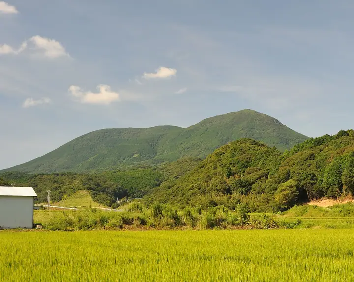
Mt. Yasumandake
安満岳
ฮิราโดะ, นางาซากิ · ความสูง 530 ม.
An approximately 530-meter peak — the highest summit of Hirado Island in Hirado City, Nagasaki Prefecture — and a sacred site registered as a component of the UNESCO World Heritage "Sacred Sites and Pilgrimage Routes in the Hidden Christian Sites in the Nagasaki Region" (the Hirado Sacred Sites and Villages component). A five-kilometer trekking course starts from a car park at 438 meters near the summit, where Ōba-raichigo bramble flowers and yamatsutsuji azaleas bloom in early May, and the upper ridge offers views as far as Uku Island and the Gotō Archipelago. The peak is No. 66 in the Japan Islands Centre's "100 Island Mountains" and is featured in the Bunken Tozan guide of Nagasaki mountains.
สรุป Mt. Yasumandake
- อากาศ: วันที่อากาศคงที่ที่สุดใน 7 วันข้างหน้าคือ อาทิตย์ 8 พฤศจิกายน: ท้องฟ้าแจ่มใส ลมกระโชกสูงสุด 10 ม./วินาที
อากาศ Mt. Yasumandake (รายชั่วโมง 2 สัปดาห์)
วันนี้พระอาทิตย์ขึ้น 06:42 ตก 17:30
| อังคาร 3/11 | พุธ 4/11 | พฤหัส 5/11 | ศุกร์ 6/11 | เสาร์ 7/11 | อาทิตย์ 8/11 | จันทร์ 9/11 | อังคาร 10/11 | พุธ 11/11 | พฤหัส 12/11 | ศุกร์ 13/11 | เสาร์ 14/11 | อาทิตย์ 15/11 | จันทร์ 16/11 | อังคาร 17/11 | |||||||||||||||||||||||||||||||||||||||||||||||||||||||||||||||||||||||
|---|---|---|---|---|---|---|---|---|---|---|---|---|---|---|---|---|---|---|---|---|---|---|---|---|---|---|---|---|---|---|---|---|---|---|---|---|---|---|---|---|---|---|---|---|---|---|---|---|---|---|---|---|---|---|---|---|---|---|---|---|---|---|---|---|---|---|---|---|---|---|---|---|---|---|---|---|---|---|---|---|---|---|---|---|---|
| เวลาญี่ปุ่น | 21 | 23 | 1 | 3 | 5 | 7 | 9 | 11 | 13 | 15 | 17 | 19 | 21 | 0 | 3 | 6 | 9 | 12 | 15 | 18 | 21 | 0 | 3 | 6 | 9 | 12 | 15 | 18 | 21 | 0 | 3 | 6 | 9 | 12 | 15 | 18 | 21 | 0 | 3 | 6 | 9 | 12 | 15 | 18 | 21 | 0 | 3 | 6 | 9 | 12 | 15 | 21 | 3 | 9 | 15 | 21 | 3 | 9 | 15 | 21 | 3 | 9 | 15 | 21 | 3 | 9 | 15 | 21 | 3 | 9 | 15 | 21 | 3 | 9 | 15 | 21 | 3 | 9 | 15 | 21 | 3 | 9 | 15 | 21 | |
  | | | | |   | | | | | | | | |   | |   |   |   |   |  |   | | |  |   | | | | | | | | | | | | | | | | | | |   | |   | | | | | |   | | | | | | | | | | |  | | | | | | | | | | | | | | | | | | | | | ||
| อุณหภูมิ | °C | 15° | 15° | 15° | 15° | 15° | 14° | 15° | 16° | 16° | 16° | 16° | 16° | 15° | 15° | 15° | 15° | 15° | 18° | 19° | 17° | 16° | 16° | 15° | 16° | 16° | 15° | 14° | 14° | 13° | 12° | 10° | 9° | 10° | 10° | 10° | 10° | 11° | 11° | 10° | 10° | 11° | 13° | 14° | 13° | 13° | 13° | 13° | 14° | 14° | 14° | 13° | 13° | 12° | 11° | 12° | 13° | 12° | 11° | 12° | 11° | 11° | 12° | 13° | 12° | 12° | 13° | 14° | 13° | 11° | 12° | 16° | 14° | 14° | 16° | 17° | 16° | 16° | 15° | 15° | 13° | 13° | 13° | 14° | 13° |
| ฝนและหิมะ | mm | 0.2 | 0.9 | 10 | 21 | 0.4 | 0.4 | 0.1 | 0.2 | 0.3 | 0.2 | 0.2 | 3.5 | 6 | 13 | 1.0 | 0.8 | 0.1 | 0.6 | 1.9 | |||||||||||||||||||||||||||||||||||||||||||||||||||||||||||||||||
| หิมะตก | cm | ||||||||||||||||||||||||||||||||||||||||||||||||||||||||||||||||||||||||||||||||||||
| หิมะสะสม | cm | 0 | 0 | 0 | 0 | 0 | 0 | 0 | 0 | 0 | 0 | 0 | 0 | 0 | 0 | 0 | 0 | 0 | 0 | 0 | 0 | 0 | 0 | 0 | 0 | 0 | 0 | 0 | 0 | 0 | 0 | 0 | 0 | 0 | 0 | 0 | 0 | 0 | 0 | 0 | 0 | 0 | 0 | 0 | 0 | 0 | 0 | 0 | 0 | 0 | 0 | 0 | 0 | 0 | 0 | 0 | 0 | 0 | 0 | 0 | 0 | 0 | 0 | 0 | 0 | 0 | 0 | 0 | 0 | 0 | 0 | 0 | 0 | 0 | 0 | 0 | 0 | 0 | 0 | 0 | 0 | 0 | 0 | 0 | 0 |
| ลม | m/s | 7 | 7 | 7 | 8 | 7 | 7 | 7 | 6 | 5 | 6 | 5 | 6 | 3 | 3 | 2 | 3 | 6 | 8 | 10 | 8 | 7 | 7 | 8 | 8 | 8 | 7 | 6 | 6 | 7 | 9 | 9 | 9 | 9 | 8 | 6 | 6 | 6 | 5 | 6 | 7 | 5 | 2 | 3 | 4 | 4 | 2 | 2 | 4 | 6 | 7 | 6 | 4 | 5 | 7 | 8 | 7 | 7 | 6 | 5 | 3 | 2 | 3 | 3 | 3 | 4 | 4 | 6 | 6 | 4 | 2 | 1 | 3 | 5 | 9 | 6 | 5 | 6 | 6 | 8 | 8 | 9 | 8 | 8 | 6 |
| ลมกระโชก | m/s | 10 | 10 | 10 | 11 | 11 | 10 | 11 | 10 | 8 | 8 | 8 | 9 | 9 | 5 | 5 | 5 | 9 | 14 | 14 | 15 | 12 | 10 | 12 | 12 | 11 | 11 | 10 | 9 | 11 | 12 | 14 | 14 | 14 | 14 | 12 | 10 | 9 | 9 | 9 | 11 | 10 | 8 | 5 | 6 | 6 | 6 | 4 | 5 | 9 | 11 | 11 | 9 | 8 | 11 | 12 | 12 | 10 | 11 | 9 | 8 | 5 | 5 | 6 | 5 | 6 | 7 | 9 | 9 | 9 | 6 | 4 | 6 | 7 | 13 | 14 | 8 | 9 | 10 | 10 | 12 | 13 | 13 | 12 | 11 |
| ทิศทางลม | ↓ | ↓ | ↓ | ↓ | ↓ | ↓ | ↓ | ↓ | ↓ | ↓ | ↓ | ↓ | ↓ | ↓ | ↓ | ↓ | ↓ | ↓ | ↓ | ↓ | ↓ | ↓ | ↓ | ↓ | ↓ | ↓ | ↓ | ↓ | ↓ | ↓ | ↓ | ↓ | ↓ | ↓ | ↓ | ↓ | ↓ | ↓ | ↓ | ↓ | ↓ | ↓ | ↓ | ↓ | ↓ | ↓ | ↓ | ↓ | ↓ | ↓ | ↓ | ↓ | ↓ | ↓ | ↓ | ↓ | ↓ | ↓ | ↓ | ↓ | ↓ | ↓ | ↓ | ↓ | ↓ | ↓ | ↓ | ↓ | ↓ | ↓ | ↓ | ↓ | ↓ | ↓ | ↓ | ↓ | ↓ | ↓ | ↓ | ↓ | ↓ | ↓ | ↓ | ↓ | |
รายชื่อที่มี Mt. Yasumandake
ข้อมูลพื้นฐาน Mt. Yasumandake
- ความสูง
- 530 ม.
- ที่ตั้ง
- ฮิราโดะ, นางาซากิ
33.337027, 129.465857 - เว็บไซต์
- www.hirado-net.com
- แผนที่เส้นทางเดินเขา
- www.hirado-net.com
- วิกิพีเดีย
- ja.wikipedia.org