
Mt. Teruishisan
晃石山
Tochigi, Tochigi · Elevation 419 m
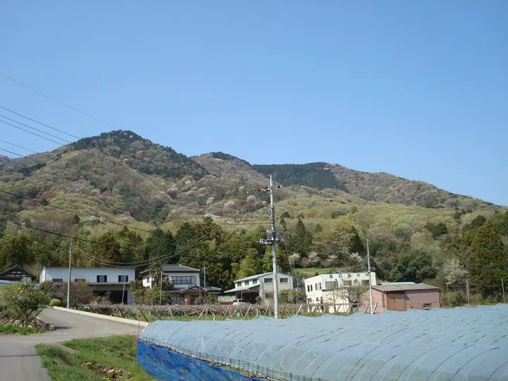
Mt. Teruishisan is a 419.1-meter peak in Tochigi City, Tochigi Prefecture, the highest summit of the Taihei range that anchors Tochigi Prefectural Taihei-zan Natural Park. Teruishi Shrine stands just below the summit, and the ridge linking Mt. Taiheisan via the Gumi-no-ki Pass to Sakura Pass and Mt. Mafuiriyama is one of the most popular station-to-station day hikes in the Kanto region, accessible from the JR Ryomo Line and Tobu Nikko Line. The peak is featured in the Kanto Hyakumeizan, Tochigi Hyakumeizan, and Nihon Hyaku Teizan lists.
Mt. Teruishisan at a glance
- Weather: The most settled day in the next 7 days is Mon, November 9: clear, gusts up to 5 m/s.
- Route: The shortest is Mount Ohirasan–Mount Teruishisan Circuit from Ajisai-zaka: about 4 h 33 min, 8.5 km, about 660 m of climbing.
Mt. Teruishisan weather (hourly, 14 days)
Sunrise today 06:06, sunset 16:44
| Tue, 11/3 | Wed, 11/4 | Thu, 11/5 | Fri, 11/6 | Sat, 11/7 | Sun, 11/8 | Mon, 11/9 | Tue, 11/10 | Wed, 11/11 | Thu, 11/12 | Fri, 11/13 | Sat, 11/14 | Sun, 11/15 | Mon, 11/16 | Tue, 11/17 | |||||||||||||||||||||||||||||||||||||||||||||||||||||||||||||||||||||||
|---|---|---|---|---|---|---|---|---|---|---|---|---|---|---|---|---|---|---|---|---|---|---|---|---|---|---|---|---|---|---|---|---|---|---|---|---|---|---|---|---|---|---|---|---|---|---|---|---|---|---|---|---|---|---|---|---|---|---|---|---|---|---|---|---|---|---|---|---|---|---|---|---|---|---|---|---|---|---|---|---|---|---|---|---|---|
| Japan time | 15 | 17 | 19 | 21 | 23 | 1 | 3 | 5 | 7 | 9 | 11 | 13 | 15 | 18 | 21 | 0 | 3 | 6 | 9 | 12 | 15 | 18 | 21 | 0 | 3 | 6 | 9 | 12 | 15 | 18 | 21 | 0 | 3 | 6 | 9 | 12 | 15 | 18 | 21 | 0 | 3 | 6 | 9 | 12 | 15 | 18 | 21 | 0 | 3 | 6 | 9 | 15 | 21 | 3 | 9 | 15 | 21 | 3 | 9 | 15 | 21 | 3 | 9 | 15 | 21 | 3 | 9 | 15 | 21 | 3 | 9 | 15 | 21 | 3 | 9 | 15 | 21 | 3 | 9 | 15 | 21 | 3 | 9 | 15 | |
  |   |  |   | |   | | |   |   | | | | |   | | | |   |   | |   | | |  | |  | | | | | | | |   | | | | | | | | | | | | | | | | | |   | | | | |   | | | |  | | | | | | | | | | | | | | | | | | | |  | | | ||
| Temperature | °C | 16° | 13° | 11° | 9° | 9° | 9° | 9° | 8° | 9° | 11° | 12° | 12° | 12° | 11° | 11° | 9° | 10° | 11° | 13° | 16° | 15° | 13° | 11° | 11° | 9° | 9° | 14° | 19° | 19° | 14° | 12° | 9° | 6° | 7° | 13° | 14° | 12° | 8° | 7° | 5° | 3° | 3° | 9° | 12° | 12° | 9° | 7° | 7° | 6° | 6° | 8° | 11° | 8° | 6° | 9° | 11° | 5° | 4° | 9° | 11° | 5° | 2° | 8° | 12° | 6° | 5° | 10° | 12° | 4° | 1° | 6° | 10° | 4° | 2° | 9° | 13° | 9° | 8° | 11° | 19° | 10° | 4° | 6° | 10° |
| Precipitation | mm | 0.1 | 0.1 | 2.5 | 7 | 14 | 7 | 0.3 | 0.5 | 1.0 | 0.2 | 0.1 | 2.9 | 0.2 | 0.2 | 1.6 | 11 | ||||||||||||||||||||||||||||||||||||||||||||||||||||||||||||||||||||
| New snow | cm | ||||||||||||||||||||||||||||||||||||||||||||||||||||||||||||||||||||||||||||||||||||
| Snow depth | cm | 0 | 0 | 0 | 0 | 0 | 0 | 0 | 0 | 0 | 0 | 0 | 0 | 0 | 0 | 0 | 0 | 0 | 0 | 0 | 0 | 0 | 0 | 0 | 0 | 0 | 0 | 0 | 0 | 0 | 0 | 0 | 0 | 0 | 0 | 0 | 0 | 0 | 0 | 0 | 0 | 0 | 0 | 0 | 0 | 0 | 0 | 0 | 0 | 0 | 0 | 0 | 0 | 0 | 0 | 0 | 0 | 0 | 0 | 0 | 0 | 0 | 0 | 0 | 0 | 0 | 0 | 0 | 0 | 0 | 0 | 0 | 0 | 0 | 0 | 0 | 0 | 0 | 0 | 0 | 0 | 0 | 0 | 0 | 0 |
| Wind | m/s | 3 | 3 | 2 | 1 | 1 | 2 | 2 | 1 | 1 | 1 | 1 | 2 | 2 | 2 | 3 | 2 | 4 | 3 | 3 | 1 | 1 | 1 | 1 | 0 | 1 | 0 | 1 | 1 | 2 | 2 | 3 | 2 | 1 | 2 | 6 | 5 | 6 | 6 | 3 | 0 | 0 | 1 | 1 | 1 | 2 | 3 | 1 | 2 | 2 | 1 | 2 | 2 | 1 | 3 | 3 | 3 | 2 | 2 | 5 | 6 | 0 | 0 | 1 | 1 | 1 | 1 | 1 | 1 | 2 | 1 | 1 | 1 | 0 | 1 | 0 | 1 | 2 | 0 | 1 | 6 | 4 | 0 | 0 | 2 |
| Wind gusts | m/s | 6 | 6 | 5 | 4 | 2 | 3 | 4 | 4 | 3 | 4 | 5 | 5 | 5 | 4 | 5 | 6 | 7 | 7 | 8 | 5 | 4 | 3 | 3 | 2 | 2 | 2 | 4 | 5 | 6 | 5 | 7 | 5 | 4 | 5 | 12 | 14 | 12 | 14 | 12 | 5 | 1 | 2 | 4 | 5 | 6 | 5 | 5 | 3 | 4 | 3 | 5 | 5 | 5 | 5 | 6 | 7 | 7 | 4 | 10 | 13 | 14 | 2 | 3 | 5 | 3 | 2 | 4 | 8 | 6 | 4 | 3 | 5 | 4 | 2 | 3 | 5 | 4 | 4 | 4 | 12 | 12 | 9 | 4 | 5 |
| Wind dir. | ↓ | ↓ | ↓ | ↓ | ↓ | ↓ | ↓ | ↓ | ↓ | ↓ | ↓ | ↓ | ↓ | ↓ | ↓ | ↓ | ↓ | ↓ | ↓ | ↓ | ↓ | ↓ | ↓ | ↓ | ↓ | ↓ | ↓ | ↓ | ↓ | ↓ | ↓ | ↓ | ↓ | ↓ | ↓ | ↓ | ↓ | ↓ | ↓ | ↓ | ↓ | ↓ | ↓ | ↓ | ↓ | ↓ | ↓ | ↓ | ↓ | ↓ | ↓ | ↓ | ↓ | ↓ | ↓ | ↓ | ↓ | ↓ | ↓ | ↓ | ↓ | ↓ | ↓ | ↓ | ↓ | ↓ | ↓ | ↓ | ↓ | ↓ | ↓ | ↓ | ↓ | ↓ | ↓ | ↓ | ↓ | ↓ | ↓ | ↓ | ↓ | ↓ | ↓ | ↓ | |
Mt. Teruishisan hiking routes
- Mount Ohirasan–Mount Teruishisan Circuit from Ajisai-zaka 8.5 km · Ascent 661 m あじさい坂駐車場, あじさい坂第二駐車場
Hiking times are estimates calculated from the terrain.
Huts, campsites and lodging near Mt. Teruishisan
Campsites
- Campsite ICHI
Lodging
- 藤や旅館
- Sun Plaza
Lists that include Mt. Teruishisan
100 Low Mountains of Japan · Kanto 100 Famous Mountains · Tochigi 100 Famous Mountains · 1000 Mountains of Japan
Mt. Teruishisan facts
- Elevation
- 419 m
- Location
- Tochigi, Tochigi
36.360308, 139.675396 - Website
- www.tochigi-kankou.or.jp
- Trail Map
- www.tochigi-kankou.or.jp (PDF)
- Wikipedia
- ja.wikipedia.org