
Mt. Takaokasan
高岳山
Hachirōgata-machi, Akita / Mitane, Akita · Elevation 231 m
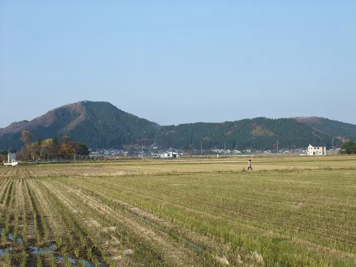
Mt. Takaokasan is a 231 m peak straddling the border of Hachirogata Town and Mitane Town in Minami-Akita District, Akita Prefecture. Its summit holds Soegawa-jinja, one of the Engishiki shrines and said to be the northernmost such shrine in Japan; a stone lantern at a torii partway up the mountain once served as a lighthouse for boats crossing the former Lake Hachiro. The mountain forms the "Takaokasan Ikoi-no-Mori" recreation forest, with trails climbing from Jofuku-in temple in Uraomachi past Murakumo Falls to a single-cherry observation deck with a triangulation point. The peak is included in the Akita Prefecture mountains guidebook.
Mt. Takaokasan at a glance
- Weather: The most settled day in the next 7 days is Wed, November 4: clear, gusts up to 9 m/s. Fri, Nov 6, Sat, Nov 7, Sun, Nov 8: strong wind (gusts up to 23 m/s).
Mt. Takaokasan weather (hourly, 14 days)
Sunrise today 06:10, sunset 16:37
| Tue, 11/3 | Wed, 11/4 | Thu, 11/5 | Fri, 11/6 | Sat, 11/7 | Sun, 11/8 | Mon, 11/9 | Tue, 11/10 | Wed, 11/11 | Thu, 11/12 | Fri, 11/13 | Sat, 11/14 | Sun, 11/15 | Mon, 11/16 | Tue, 11/17 | |||||||||||||||||||||||||||||||||||||||||||||||||||||||||||||||||||||
|---|---|---|---|---|---|---|---|---|---|---|---|---|---|---|---|---|---|---|---|---|---|---|---|---|---|---|---|---|---|---|---|---|---|---|---|---|---|---|---|---|---|---|---|---|---|---|---|---|---|---|---|---|---|---|---|---|---|---|---|---|---|---|---|---|---|---|---|---|---|---|---|---|---|---|---|---|---|---|---|---|---|---|---|
| Japan time | 21 | 23 | 1 | 3 | 5 | 7 | 9 | 11 | 13 | 15 | 17 | 19 | 21 | 0 | 3 | 6 | 9 | 12 | 15 | 18 | 21 | 0 | 3 | 6 | 9 | 12 | 15 | 18 | 21 | 0 | 3 | 6 | 9 | 12 | 15 | 18 | 21 | 0 | 3 | 6 | 9 | 12 | 15 | 18 | 21 | 0 | 3 | 6 | 9 | 15 | 21 | 3 | 9 | 15 | 21 | 3 | 9 | 15 | 21 | 3 | 9 | 15 | 21 | 3 | 9 | 15 | 21 | 3 | 9 | 15 | 21 | 3 | 9 | 15 | 21 | 3 | 9 | 15 | 21 | 3 | 9 | 15 | |
  |  |   | | |  | | | | | | | | |   |   |   | |   |   | | | | |   |   | | | |  | | |   | | | | | | | | |   | | |   | | | | | | | | |   | | | | | | | | | | | | | | | | |  | | | | | | | | | | | | ||
| Temperature | °C | 7° | 7° | 8° | 8° | 9° | 10° | 12° | 13° | 13° | 12° | 8° | 6° | 4° | 5° | 7° | 11° | 12° | 14° | 12° | 11° | 10° | 11° | 12° | 12° | 15° | 14° | 13° | 9° | 8° | 6° | 5° | 5° | 5° | 6° | 6° | 5° | 5° | 5° | 5° | 5° | 6° | 7° | 7° | 6° | 6° | 6° | 6° | 4° | 5° | 6° | 4° | 2° | 5° | 9° | 4° | 6° | 4° | 7° | 3° | 3° | 9° | 9° | 7° | 5° | 6° | 6° | 5° | 4° | 7° | 9° | 1° | 2° | 9° | 11° | 9° | 9° | 9° | 6° | 4° | 5° | 6° | 8° |
| Precipitation | mm | 0.2 | 0.8 | 0.1 | 0.1 | 0.6 | 0.2 | 1.1 | 0.5 | 3.2 | 3.6 | 1.9 | 0.6 | 0.8 | 1.1 | 0.5 | 0.3 | 0.5 | 0.8 | 0.6 | 1.2 | 1.2 | 0.4 | 0.5 | 0.2 | 0.2 | 0.1 | 0.1 | 0.3 | 0.4 | 2.3 | 6 | 5 | 0.3 | 0.2 | 2.3 | 3.8 | 0.2 | 2.8 | 6 | 2.1 | 5.0 | 1.1 | ||||||||||||||||||||||||||||||||||||||||
| New snow | cm | – | – | <.1 | |||||||||||||||||||||||||||||||||||||||||||||||||||||||||||||||||||||||||||||||
| Snow depth | cm | 0 | 0 | 0 | 0 | 0 | 0 | 0 | 0 | 0 | 0 | 0 | 0 | 0 | 0 | 0 | 0 | 0 | 0 | 0 | 0 | 0 | 0 | 0 | 0 | 0 | 0 | 0 | 0 | 0 | 0 | 0 | 0 | 0 | 0 | 0 | 0 | 0 | 0 | 0 | 0 | 0 | 0 | 0 | 0 | 0 | 0 | 0 | 0 | 0 | 0 | 0 | 0 | 0 | 0 | 0 | 0 | 0 | 0 | 0 | 0 | 0 | 0 | 0 | 0 | 0 | 0 | 0 | 0 | 0 | 0 | 0 | 0 | 0 | 0 | 0 | 0 | 0 | 0 | 0 | 0 | 0 | 0 |
| Wind | m/s | 1 | 2 | 2 | 3 | 3 | 4 | 5 | 4 | 2 | 2 | 1 | 2 | 3 | 3 | 1 | 5 | 4 | 4 | 3 | 3 | 2 | 1 | 2 | 2 | 5 | 5 | 7 | 7 | 8 | 8 | 6 | 8 | 10 | 11 | 11 | 10 | 8 | 8 | 9 | 8 | 8 | 8 | 7 | 5 | 4 | 4 | 4 | 2 | 4 | 4 | 3 | 2 | 3 | 2 | 6 | 3 | 4 | 4 | 1 | 2 | 4 | 4 | 1 | 4 | 5 | 6 | 3 | 3 | 2 | 2 | 2 | 2 | 2 | 3 | 3 | 1 | 1 | 7 | 6 | 4 | 1 | 3 |
| Wind gusts | m/s | 6 | 3 | 5 | 6 | 6 | 7 | 9 | 9 | 8 | 6 | 4 | 3 | 5 | 6 | 6 | 9 | 10 | 7 | 7 | 7 | 5 | 3 | 5 | 5 | 10 | 14 | 15 | 13 | 15 | 17 | 15 | 15 | 20 | 22 | 23 | 21 | 18 | 15 | 17 | 16 | 15 | 16 | 15 | 14 | 9 | 8 | 7 | 7 | 8 | 8 | 8 | 7 | 6 | 6 | 12 | 15 | 11 | 13 | 7 | 5 | 8 | 9 | 7 | 7 | 10 | 12 | 11 | 5 | 5 | 6 | 5 | 5 | 4 | 7 | 6 | 8 | 3 | 13 | 14 | 10 | 7 | 7 |
| Wind dir. | ↓ | ↓ | ↓ | ↓ | ↓ | ↓ | ↓ | ↓ | ↓ | ↓ | ↓ | ↓ | ↓ | ↓ | ↓ | ↓ | ↓ | ↓ | ↓ | ↓ | ↓ | ↓ | ↓ | ↓ | ↓ | ↓ | ↓ | ↓ | ↓ | ↓ | ↓ | ↓ | ↓ | ↓ | ↓ | ↓ | ↓ | ↓ | ↓ | ↓ | ↓ | ↓ | ↓ | ↓ | ↓ | ↓ | ↓ | ↓ | ↓ | ↓ | ↓ | ↓ | ↓ | ↓ | ↓ | ↓ | ↓ | ↓ | ↓ | ↓ | ↓ | ↓ | ↓ | ↓ | ↓ | ↓ | ↓ | ↓ | ↓ | ↓ | ↓ | ↓ | ↓ | ↓ | ↓ | ↓ | ↓ | ↓ | ↓ | ↓ | ↓ | ↓ | |
Huts, campsites and lodging near Mt. Takaokasan
Lodging
- Sato Ryokan
- 伊藤旅館
- 旅館 新やなぎ館
Mt. Takaokasan facts
- Elevation
- 231 m
- Location
- Hachirōgata-machi, Akita / Mitane, Akita
39.973429, 140.087920 - Website
- www.town.hachirogata.akita.jp
- Wikipedia
- ja.wikipedia.org