
Mt. Sanganesan
三ヶ根山
Kota, Aichi / Nishio, Aichi / Gamagōri-shi, Aichi · Elevation 321 m
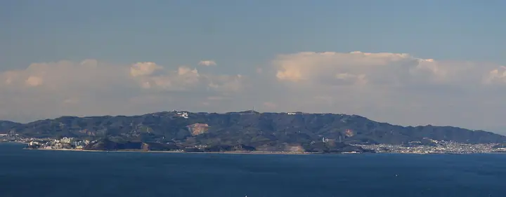
Mt. Sanganesan, 321 m, is the highest peak of the Hazu mountain group in Aichi Prefecture, set in Mikawa Bay Quasi-National Park where the boundaries of Kōta Town, Nishio City and Gamagōri City meet. The toll-road Sanganesan Skyline runs along its ridge past the Junkoku-Shichishi Mausoleum (a memorial to the seven A-class war criminals executed after WWII), a hydrangea garden and outcrops of the Fukamizo Fault. Kōta Town maintains an official hiking course from JR Sangane Station via the Ichinose trailhead, signposted by six numbered markers, ending below the summit. The view from the top sweeps across Mikawa Bay to the Chita and Atsumi peninsulas.
Mt. Sanganesan at a glance
- Weather: The most settled day in the next 7 days is Wed, November 4: cloudy, gusts up to 5 m/s. Sat, Nov 7: strong wind (gusts up to 19 m/s).
Mt. Sanganesan weather (hourly, 14 days)
Sunrise today 06:13, sunset 16:57
| Tue, 11/3 | Wed, 11/4 | Thu, 11/5 | Fri, 11/6 | Sat, 11/7 | Sun, 11/8 | Mon, 11/9 | Tue, 11/10 | Wed, 11/11 | Thu, 11/12 | Fri, 11/13 | Sat, 11/14 | Sun, 11/15 | Mon, 11/16 | Tue, 11/17 | |||||||||||||||||||||||||||||||||||||||||||||||||||||||||||||||||||||||
|---|---|---|---|---|---|---|---|---|---|---|---|---|---|---|---|---|---|---|---|---|---|---|---|---|---|---|---|---|---|---|---|---|---|---|---|---|---|---|---|---|---|---|---|---|---|---|---|---|---|---|---|---|---|---|---|---|---|---|---|---|---|---|---|---|---|---|---|---|---|---|---|---|---|---|---|---|---|---|---|---|---|---|---|---|---|
| Japan time | 15 | 17 | 19 | 21 | 23 | 1 | 3 | 5 | 7 | 9 | 11 | 13 | 15 | 18 | 21 | 0 | 3 | 6 | 9 | 12 | 15 | 18 | 21 | 0 | 3 | 6 | 9 | 12 | 15 | 18 | 21 | 0 | 3 | 6 | 9 | 12 | 15 | 18 | 21 | 0 | 3 | 6 | 9 | 12 | 15 | 18 | 21 | 0 | 3 | 6 | 9 | 15 | 21 | 3 | 9 | 15 | 21 | 3 | 9 | 15 | 21 | 3 | 9 | 15 | 21 | 3 | 9 | 15 | 21 | 3 | 9 | 15 | 21 | 3 | 9 | 15 | 21 | 3 | 9 | 15 | 21 | 3 | 9 | 15 | |
 |  |   | | | | | |   |   |   | | |   |   | | | | | |   |  | |   | |   | | | | | | | | | | | | | | | | | | | | | | | | | | |   | | | | | | | | |  | | | | | | | | | | | | | |   | | | | | | | | | ||
| Temperature | °C | 19° | 16° | 13° | 12° | 11° | 10° | 9° | 9° | 9° | 13° | 15° | 15° | 15° | 14° | 12° | 12° | 12° | 12° | 16° | 20° | 18° | 16° | 14° | 13° | 13° | 14° | 17° | 19° | 19° | 15° | 13° | 12° | 10° | 9° | 11° | 13° | 13° | 10° | 8° | 7° | 7° | 6° | 10° | 14° | 14° | 11° | 10° | 9° | 8° | 8° | 12° | 16° | 10° | 7° | 12° | 15° | 11° | 8° | 10° | 12° | 8° | 5° | 8° | 14° | 8° | 6° | 11° | 14° | 8° | 5° | 10° | 14° | 12° | 12° | 15° | 15° | 15° | 14° | 15° | 19° | 11° | 7° | 8° | 10° |
| Precipitation | mm | 8 | 3.3 | 1.9 | 0.4 | 0.1 | 5 | 18 | 14 | 0.1 | 1.1 | ||||||||||||||||||||||||||||||||||||||||||||||||||||||||||||||||||||||||||
| New snow | cm | ||||||||||||||||||||||||||||||||||||||||||||||||||||||||||||||||||||||||||||||||||||
| Snow depth | cm | 0 | 0 | 0 | 0 | 0 | 0 | 0 | 0 | 0 | 0 | 0 | 0 | 0 | 0 | 0 | 0 | 0 | 0 | 0 | 0 | 0 | 0 | 0 | 0 | 0 | 0 | 0 | 0 | 0 | 0 | 0 | 0 | 0 | 0 | 0 | 0 | 0 | 0 | 0 | 0 | 0 | 0 | 0 | 0 | 0 | 0 | 0 | 0 | 0 | 0 | 0 | 0 | 0 | 0 | 0 | 0 | 0 | 0 | 0 | 0 | 0 | 0 | 0 | 0 | 0 | 0 | 0 | 0 | 0 | 0 | 0 | 0 | 0 | 0 | 0 | 0 | 0 | 0 | 0 | 0 | 0 | 0 | 0 | 0 |
| Wind | m/s | 4 | 3 | 2 | 3 | 3 | 3 | 3 | 3 | 2 | 1 | 1 | 1 | 1 | 1 | 2 | 2 | 3 | 4 | 3 | 1 | 1 | 0 | 1 | 1 | 1 | 3 | 5 | 6 | 6 | 6 | 6 | 6 | 7 | 6 | 7 | 8 | 8 | 7 | 6 | 5 | 5 | 5 | 5 | 4 | 3 | 2 | 3 | 3 | 3 | 3 | 3 | 4 | 2 | 1 | 1 | 1 | 4 | 7 | 7 | 8 | 6 | 4 | 3 | 3 | 2 | 2 | 4 | 7 | 5 | 3 | 0 | 2 | 2 | 2 | 3 | 4 | 2 | 2 | 3 | 8 | 7 | 5 | 4 | 2 |
| Wind gusts | m/s | 10 | 8 | 5 | 6 | 6 | 6 | 6 | 6 | 5 | 4 | 4 | 4 | 3 | 3 | 7 | 7 | 7 | 7 | 8 | 7 | 5 | 3 | 2 | 2 | 3 | 8 | 12 | 14 | 15 | 15 | 13 | 13 | 15 | 16 | 16 | 19 | 19 | 17 | 14 | 12 | 10 | 11 | 10 | 11 | 10 | 6 | 5 | 6 | 6 | 5 | 7 | 10 | 9 | 5 | 4 | 5 | 9 | 17 | 16 | 19 | 17 | 12 | 9 | 9 | 8 | 5 | 9 | 15 | 15 | 10 | 5 | 6 | 6 | 5 | 7 | 9 | 9 | 7 | 8 | 18 | 17 | 14 | 11 | 8 |
| Wind dir. | ↓ | ↓ | ↓ | ↓ | ↓ | ↓ | ↓ | ↓ | ↓ | ↓ | ↓ | ↓ | ↓ | ↓ | ↓ | ↓ | ↓ | ↓ | ↓ | ↓ | ↓ | ↓ | ↓ | ↓ | ↓ | ↓ | ↓ | ↓ | ↓ | ↓ | ↓ | ↓ | ↓ | ↓ | ↓ | ↓ | ↓ | ↓ | ↓ | ↓ | ↓ | ↓ | ↓ | ↓ | ↓ | ↓ | ↓ | ↓ | ↓ | ↓ | ↓ | ↓ | ↓ | ↓ | ↓ | ↓ | ↓ | ↓ | ↓ | ↓ | ↓ | ↓ | ↓ | ↓ | ↓ | ↓ | ↓ | ↓ | ↓ | ↓ | ↓ | ↓ | ↓ | ↓ | ↓ | ↓ | ↓ | ↓ | ↓ | ↓ | ↓ | ↓ | ↓ | ↓ | |
Lists that include Mt. Sanganesan
Mt. Sanganesan facts
- Elevation
- 321 m
- Location
- Kota, Aichi / Nishio, Aichi / Gamagōri-shi, Aichi
34.815913, 137.161753 - National Park
- 三河湾国定公園
- Website
- www.town.kota.lg.jp
- Trail Map
- www.town.kota.lg.jp (PDF)
- Access Information
- www.town.kota.lg.jp (PDF)
- Wikipedia
- ja.wikipedia.org