
Mt. Ryozen
霊山
Sōma-shi, Fukushima / Date, Fukushima · Elevation 825 m
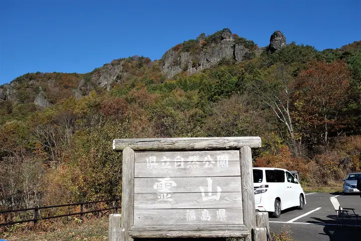
Ryozen (825 m) is a mountain in Date, Fukushima Prefecture, and a symbol of the city. Its profile of jutting crags was designated a National Historic Site and Place of Scenic Beauty in 1934, and it is famed for autumn colour. Opened by the monk Ennin in 859, it later held Ryozen Castle, built by Kitabatake Akiie during the Nanbokucho period. Well-maintained paths wind among rock formations such as Benten-iwa and Ari-no-towatari, and it appears on numerous lists, including the "New 100 Famous Mountains of Japan," "100 Famous Mountains of Tohoku," and "Utsukushima 100 Mountains."
Mt. Ryozen at a glance
- Weather: The most settled day in the next 7 days is Wed, November 4: clear, gusts up to 5 m/s. Sat, Nov 7, Sun, Nov 8: strong wind (gusts up to 17 m/s).
- Route: The shortest is Mount Ryōzen Rock-Formation Circuit: about 2 h 45 min, 4.6 km, about 390 m of climbing.
Mt. Ryozen weather (hourly, 14 days)
Sunrise today 06:04, sunset 16:38
| Tue, 11/3 | Wed, 11/4 | Thu, 11/5 | Fri, 11/6 | Sat, 11/7 | Sun, 11/8 | Mon, 11/9 | Tue, 11/10 | Wed, 11/11 | Thu, 11/12 | Fri, 11/13 | Sat, 11/14 | Sun, 11/15 | Mon, 11/16 | Tue, 11/17 | |||||||||||||||||||||||||||||||||||||||||||||||||||||||||||||||||||||||
|---|---|---|---|---|---|---|---|---|---|---|---|---|---|---|---|---|---|---|---|---|---|---|---|---|---|---|---|---|---|---|---|---|---|---|---|---|---|---|---|---|---|---|---|---|---|---|---|---|---|---|---|---|---|---|---|---|---|---|---|---|---|---|---|---|---|---|---|---|---|---|---|---|---|---|---|---|---|---|---|---|---|---|---|---|---|
| Japan time | 15 | 17 | 19 | 21 | 23 | 1 | 3 | 5 | 7 | 9 | 11 | 13 | 15 | 18 | 21 | 0 | 3 | 6 | 9 | 12 | 15 | 18 | 21 | 0 | 3 | 6 | 9 | 12 | 15 | 18 | 21 | 0 | 3 | 6 | 9 | 12 | 15 | 18 | 21 | 0 | 3 | 6 | 9 | 12 | 15 | 18 | 21 | 0 | 3 | 6 | 9 | 15 | 21 | 3 | 9 | 15 | 21 | 3 | 9 | 15 | 21 | 3 | 9 | 15 | 21 | 3 | 9 | 15 | 21 | 3 | 9 | 15 | 21 | 3 | 9 | 15 | 21 | 3 | 9 | 15 | 21 | 3 | 9 | 15 | |
 |  |   | | | | | |   | | | | | |   |   |   | |   | | | |   | | | | |   |   | | | | | | | | |   | | | | |   |   | | | | | | | | | |   | | | | | | | | | | | | | | | |  | | | | | | | | | | | | | | | ||
| Temperature | °C | 9° | 6° | 4° | 3° | 3° | 3° | 2° | 1° | 3° | 8° | 10° | 12° | 11° | 6° | 7° | 6° | 7° | 7° | 8° | 9° | 9° | 9° | 8° | 9° | 7° | 7° | 12° | 15° | 15° | 11° | 8° | 5° | 5° | 3° | 4° | 5° | 5° | 3° | 3° | 3° | 2° | 1° | 4° | 5° | 4° | 3° | 2° | 3° | 2° | 1° | 3° | 7° | 1° | 0° | 3° | 5° | 1° | 1° | 3° | 8° | 1° | 1° | 4° | 6° | 0° | 3° | 6° | 5° | 1° | -1° | 4° | 8° | 1° | 0° | 6° | 11° | 7° | 7° | 10° | 9° | 2° | 0° | 3° | 6° |
| Precipitation | mm | 1.2 | 3.7 | 10 | 8 | 4.8 | 0.5 | 0.2 | 0.2 | 0.3 | 0.1 | 0.3 | 0.7 | 0.5 | 0.2 | 0.5 | 0.3 | 0.1 | 0.7 | 3.3 | 10 | 0.1 | 0.7 | 0.5 | |||||||||||||||||||||||||||||||||||||||||||||||||||||||||||||
| New snow | cm | ||||||||||||||||||||||||||||||||||||||||||||||||||||||||||||||||||||||||||||||||||||
| Snow depth | cm | 0 | 0 | 0 | 0 | 0 | 0 | 0 | 0 | 0 | 0 | 0 | 0 | 0 | 0 | 0 | 0 | 0 | 0 | 0 | 0 | 0 | 0 | 0 | 0 | 0 | 0 | 0 | 0 | 0 | 0 | 0 | 0 | 0 | 0 | 0 | 0 | 0 | 0 | 0 | 0 | 0 | 0 | 0 | 0 | 0 | 0 | 0 | 0 | 0 | 0 | 0 | 0 | 0 | 0 | 0 | 0 | 0 | 0 | 0 | 0 | 0 | 0 | 0 | 0 | 0 | 0 | 0 | 0 | 0 | 0 | 0 | 0 | 0 | 0 | 0 | 0 | 0 | 0 | 0 | 0 | 0 | 0 | 0 | 0 |
| Wind | m/s | 6 | 5 | 3 | 2 | 0 | 0 | 1 | 1 | 1 | 1 | 1 | 1 | 2 | 3 | 2 | 2 | 1 | 1 | 2 | 2 | 2 | 1 | 1 | 2 | 1 | 1 | 1 | 3 | 3 | 2 | 4 | 7 | 5 | 6 | 6 | 6 | 6 | 6 | 5 | 4 | 5 | 4 | 2 | 6 | 6 | 5 | 3 | 3 | 2 | 2 | 1 | 2 | 2 | 1 | 2 | 3 | 2 | 2 | 4 | 7 | 2 | 2 | 2 | 1 | 1 | 3 | 5 | 7 | 4 | 2 | 1 | 2 | 3 | 3 | 2 | 1 | 1 | 1 | 1 | 6 | 6 | 5 | 3 | 2 |
| Wind gusts | m/s | 15 | 13 | 11 | 6 | 4 | 2 | 3 | 3 | 3 | 4 | 5 | 5 | 5 | 7 | 6 | 5 | 4 | 4 | 4 | 5 | 6 | 4 | 3 | 4 | 4 | 4 | 5 | 8 | 9 | 8 | 9 | 15 | 15 | 14 | 16 | 16 | 17 | 15 | 13 | 13 | 12 | 12 | 10 | 15 | 17 | 13 | 11 | 7 | 6 | 6 | 5 | 5 | 5 | 4 | 5 | 8 | 7 | 9 | 11 | 18 | 16 | 6 | 7 | 7 | 4 | 7 | 12 | 16 | 15 | 10 | 5 | 6 | 7 | 7 | 6 | 7 | 5 | 4 | 6 | 13 | 16 | 16 | 12 | 8 |
| Wind dir. | ↓ | ↓ | ↓ | ↓ | ↓ | ↓ | ↓ | ↓ | ↓ | ↓ | ↓ | ↓ | ↓ | ↓ | ↓ | ↓ | ↓ | ↓ | ↓ | ↓ | ↓ | ↓ | ↓ | ↓ | ↓ | ↓ | ↓ | ↓ | ↓ | ↓ | ↓ | ↓ | ↓ | ↓ | ↓ | ↓ | ↓ | ↓ | ↓ | ↓ | ↓ | ↓ | ↓ | ↓ | ↓ | ↓ | ↓ | ↓ | ↓ | ↓ | ↓ | ↓ | ↓ | ↓ | ↓ | ↓ | ↓ | ↓ | ↓ | ↓ | ↓ | ↓ | ↓ | ↓ | ↓ | ↓ | ↓ | ↓ | ↓ | ↓ | ↓ | ↓ | ↓ | ↓ | ↓ | ↓ | ↓ | ↓ | ↓ | ↓ | ↓ | ↓ | ↓ | ↓ | |
Mt. Ryozen hiking routes
- Mount Ryōzen Rock-Formation Circuit 4.6 km · Ascent 389 m 霊山登山口 (parking)
- Mount Ryozen Rock Circuit via Mioroshi Rock, Gomadan and Tonomono-mi Rock 4.8 km · Ascent 411 m 霊山登山口 (parking)
Hiking times are estimates calculated from the terrain.
Huts, campsites and lodging near Mt. Ryozen
Campsites
- 霊山湧水の里キャンプ場
Lists that include Mt. Ryozen
New Japan 100 Famous Mountains · 100 Low Mountains of Japan · Tohoku 100 Famous Mountains · Utsukushima 100 Famous Mountains (Fukushima Prefecture) · 30 Peaks of Fukushima · Elevations of 1003 Mountains of Japan · 1000 Mountains of Japan
Mt. Ryozen facts
- Also known as
- 東物見岩
- Elevation
- 825 m
- Location
- Sōma-shi, Fukushima / Date, Fukushima
37.768798, 140.687367 - Website
- www.city.fukushima-date.lg.jp
- Trail Map
- www.city.fukushima-date.lg.jp (PDF)
- Wikipedia
- ja.wikipedia.org